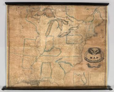
Maps of United States

United States.
1 : 1900800 Lay, Amos
Amplissimae regionis Mississipi seu provinciae Ludovicianae â R.P. Ludovico Hennepin Francisc. Miss. in America septentrionali anno 1687
1 : 6500000
Amplissimae regionis Mississipi seu Provinciae Ludovicianae â R.P. Ludovico Hennepin Francisc Miss in America Septentrionali anno 1687
1 : 1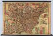
Railroad Map Of The United States And Of The Dominion Of Canada.
1 : 2280960 Watson, Gaylord
Composite: United States of Nth. America.
1 : 1584000 Tardieu, P.F.
Amplissimae regionis Mississipi seu Provinciae Ludovicianae â R. P. Ludovico Hennepin francisc miss. in America septentrionali anno 1687 detectae, nunc Gallorum coloniis et actionum negotiis toto orbe celeberrimae, nova tabula
1 : 6350000 Mississippi, řeka-oblast Homann, Johann Baptist a Io. Bapt. Homanno
A map of the United States, from the latest surveys.
1 : 4822000 Tuttle, Joseph Willard, 1813-1888
Map of the United States / Euphemia Fenno.
from Whole Euphemia Fenno,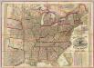
Watson's New County and Railroad Map of the United States.
1 : 2154240 Watson, Gaylord
Vereinigten Staaten von Nord America
Neuester Schul-Atlas Walch, Johann im Verlag bei Joh. Walch
4. Population 1830-1860.
1 : 8450000 Gannett, Henry, 1846-1914; United States. Census Office
3. Population 1790-1820.
1 : 8450000 Gannett, Henry, 1846-1914; United States. Census Office
Foreign population 1870.
1 : 7200000 Walker, Francis Amasa, 1840-1897
US Population 1850.
1 : 7100000 Walker, Francis Amasa, 1840-1897
Illiteracy 1870.
1 : 7100000 Walker, Francis Amasa, 1840-1897
Enteric, cerebro-spinal, typhus deaths.
1 : 7200000 Walker, Francis Amasa, 1840-1897
Foreign parentage 1870.
1 : 7100000 Walker, Francis Amasa, 1840-1897
Colored population proportion 1870.
1 : 7100000 Walker, Francis Amasa, 1840-1897
White male illiteracy.
1 : 7100000 Walker, Francis Amasa, 1840-1897
Predominating sex US.
1 : 7200000 Walker, Francis Amasa, 1840-1897
US Population 1860.
1 : 7100000 Walker, Francis Amasa, 1840-1897
US Population 1790-1820.
1 : 14300000 Walker, Francis Amasa, 1840-1897
Public indebtedness US.
1 : 7200000 Walker, Francis Amasa, 1840-1897
Consumption deaths US.
1 : 7200000 Walker, Francis Amasa, 1840-1897
Intestinal diseases deaths US.
1 : 7200000 Walker, Francis Amasa, 1840-1897
Malarial deaths US.
1 : 7200000 Walker, Francis Amasa, 1840-1897
Taxation per capita US.
1 : 7200000 Walker, Francis Amasa, 1840-1897
Wealth distribution US.
1 : 7200000 Walker, Francis Amasa, 1840-1897
Foreign population proportion 1870.
1 : 7200000 Walker, Francis Amasa, 1840-1897
Irish, German population 1870.
1 : 14300000 Walker, Francis Amasa, 1840-1897
Foreign parentage proportion 1870.
1 : 7100000 Walker, Francis Amasa, 1840-1897
Farms, production, corn, dairy.
1 : 14300000 Walker, Francis Amasa, 1840-1897
Crops US.
1 : 14300000 Walker, Francis Amasa, 1840-1897
Birth rate US.
1 : 7200000 Walker, Francis Amasa, 1840-1897