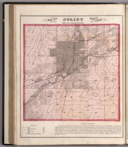
Maps of Preston Heights

Joliet Township, Town 35 N. Range 10 East, Will County, Illinois.
1 : 31680 Thompson Bro's & Burr
Joliet
1 : 24000
Joliet
1 : 24000
Joliet
1 : 24000
Joliet
1 : 24000
Joliet
1 : 24000
Joliet
1 : 24000
Joliet
1 : 62500
Joliet
1 : 62500
Joliet
1 : 62500
Joliet
1 : 62500
Joliet
1 : 62500
Joliet
1 : 62500
Joliet
1 : 62500
Joliet
1 : 62500
Joliet
1 : 62500
Joliet
1 : 62500
Elwood
1 : 24000
Elwood
1 : 24000
Elwood
1 : 24000
Elwood
1 : 24000
Cook, Dupage, Will, Kankakee, Kane & Kendall.
1 : 130000 Rees, J. H.
Kendall, Will, Grundy, and Cook counties, Lacon, Morris, Wilmington and Braidwood.
1 : 180000 Warner & Beers
Map of Iroquois County.
1 : 165000 Warner & Beers
McHenry, Lake, Kane, Du Page, Cook, Will, Kendall counties.
1 : 350000 Campbell, R.A.
Aurora
1 : 250000
Aurora
1 : 250000
Aurora
1 : 250000
Aurora
1 : 250000