Maps of Denmark

Denmark, Sleswig, Holstein.
1 : 823680 Stanford, Edward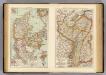
Denmark, Alsace-Lorraine, Palatinate.
1 : 1500000 Andree, Richard; Times (London, England)
Regni Daniae Novißima et Accuratißima Tabula
1 : 1100000 Mollova mapová sbírka Visscher, Nicolaes Visscher, Nicolaus
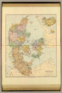
Denmark.
1 : 1800000 Mitchell, Samuel Augustus
Denmark.
1 : 1800000 Mitchell, Samuel Augustus
Daenemarck.
Dánsko Güssefeld, Franz L. Mollo, Tranquillo Tranquillo Mollo
Daenemarck
1 : 1260000 Bornholm (Dánsko) Mollo, Tranquillo Tranquillo Mollo
Daenemarck
1 : 1245000 Dánsko Tranquillo Mollo
Daenemarck.
Dánsko Güssefeld, Franz L. Mollo, Tranquillo Tranquillo Mollo
Dänemark mit Schleswig, Holstein
Dánsko
Denmark.
1 : 1500000 Colton, G.W.
Denmark.
1 : 1500000 Colton, G.W.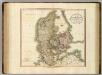
Denmark.
1 : 1100000 Cary, John, ca. 1754-1835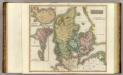
Denmark, Iceland, Feroe Islands.
1 : 960000 Thomson, John
Daenemark mit Holstein und Lauenburg auch südlicher Theil von Schweden
1 : 3200000 Dánsko
Daenemark
Allgemeiner Atlas [Walch, Johannes] im Verlag bei Johannes Walch
Dania Regnum [Karte], in: Novus Atlas, das ist, Weltbeschreibung, Bd. 1, S. 33.
1 Karte aus Atlas Blaeu, Joan Blaeu, Willem Janszoon
Daenemark
E. von Sydow's Schul-Atlas in sechs und dreissig Karten Sydow, Emil von bei Justus Perthes
Das Königreich Daenemark nebst seinen Nebenlaendern in Europa
1 : 1100000 entworfen und gezeichnet von C.F. Weiland Weimar : Verlag des Geographischen Instituts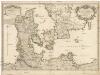
Le royaume de Danemark
1 : 1200000 Dánsko Sanson, Guillaume Cordier, Louis chez H. Iaillot
Denmark.
1 : 1800000 Tanner, Henry S.
Daenemark
Dánsko Berra, Marco bei Marco Berra
Dania Regnum [Karte], in: Theatrum orbis terrarum, sive, Atlas novus, Bd. 1, S. 47.
1 Karte aus Atlas Blaeu, Joan Blaeu, Willem Janszoon
[Daenemark mit Holstein und Lauenburg; auch Island und Fär-Öer]
Schul-Atlas über alle Theile der Erde nach dem neuesten Zustande, und über das Weltgebäude Stieler, Adolf bei Justus Perthes
Dania Regnum [Karte], in: Le théâtre du monde, ou, Nouvel atlas contenant les chartes et descriptions de tous les païs de la terre, Bd. 1, S. 49.
1 Karte aus Atlas Blaeu, Willem Janszoon und Blaeu, Joan Blaeu, Willem Janszoon
[Königreich Daenemark]
Neuester Schul-Atlas Walch, Johann im Verlag bei Joh. Walch
Pas-Caarte van't Schager-Rack, De Sondt en de Belt. [Karte], in: De Nieuwe Groote Vermeerderde Zee-Atlas ofte Water-Werelt, S. 21.
1 Karte aus Atlas Doncker, Hendrick
Denmark.
1 : 1393920 Colton, G.W.
[Daenemark mit Schleswig, Holstein und Lauenburg auch Südl. Theil v. Schweden]
Hand-Atlas über alle Theile der Erde nach dem neuesten Zustande und über das Weltgebäude Stieler, Adolf bei Justus Perthes