Maps of Piedmont

The Western Parts of Virginia, Pennsylvania, Maryland and North Carolina.
1 : 1140480 Hutchins, Thomas
Map of the Back Settlements.
1 : 6336000 Morse, Jedidiah
Country drained by the Mississippi Eastern Section.
1 : 4752000 Long, Stephen H.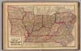
Delaware, Illinois, Indiana, Iowa ... North Carolina ... Tennessee, Virginia.
1 : 3000000 Lloyd, H.H.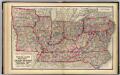
Delaware, Illinois, Indiana, Iowa ... North Carolina ... Tennessee, Virginia.
1 : 3000000 Walling, H. F.
County map of the State of Illinois ; Plan of Chicago [inset].
from New general atlas.
151. Centers farm, agricultural products, population, manufactures.
1 : 7000000 Gannett, Henry, 1846-1914; United States. Census Office
126. Centers of population, farms, agricultural products, manufactures 1790-1900.
1 : 7000000 Gannett, Henry, 1846-1914; United States. Census Office
200-201. United States of America, North East Central. The World Atlas.
1 : 2500000 USSR (Union of Soviet Socialist Republics).
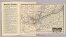
Tourist through car line, Louisville & Nashville Railroad.
1 : 1900000 Louisville and Nashville Railroad Company
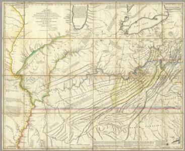
A Map of the British American plantations, extending from Boston in New England to Georgia, including all the back settlements in the respective provinces, as far as the Mississipi
1 : 6350000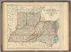
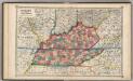
States Of Delaware, Maryland, Virginia (with the District of Columbia) North Carolina, Ohio, Kentucky, Tennessee, And Indiana.
1 : 3453120 Rogers, Henry Darwin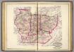
Ind., Ill., Mo., Ohio, Ky, Tenn.
1 : 2100000 Asher, Adams & Higgins; Higgins & Ryan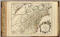
Cours de l'Ohio, Nlle. Angleterre, Nlle. York, Pensylvanie, Virginie, Caroline.
1 : 2900000 Robert de Vaugondy, Gilles, 1688-1766
Ohio, Indiana, Kentucky, and Tennessee.
1 : 3651000 Fisher, Richard Swainson
Die Staaten von Missouri, Illinois, Indiana, Ohio, Kentucky und Tennessee
Map Wabash Railway.
1 : 6623200 Wabash Railway Company
County map of Ohio and Indiana.
from New general atlas.
Shell Sectional Map No. 4 - East Central States.
1 : 1710720 Shell Oil Company
Western States.
1 : 6400000 Adams, Daniel
Western States, United States.
Goodrich, S.G.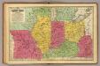
Western States.
1 : 3200000 Mitchell, Samuel Augustus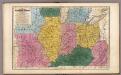
Map of the Western States.
1 : 3200000 Mitchell, Samuel Augustus
Western states, territories.
1 : 6400000 Grigg, John
Army of the Cumberland.
1 : 7800000 National Tribune Co.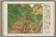
Soil Map of the United States, Section 7. Atlas of American Agriculture.
1 : 2500000 Marbut, Curtis F.
The state of Virginia : from the best authorities / by Samuel Lewis, 1809 ; Smither, sculpt.
from Carey's American atlas.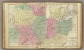
Western U.S.
1 : 3000000 Cornell, S. S. (Sarah S.)
N. W. Territory.
1 : 8236800 Carey, Mathew