Maps of Ozark Plateau
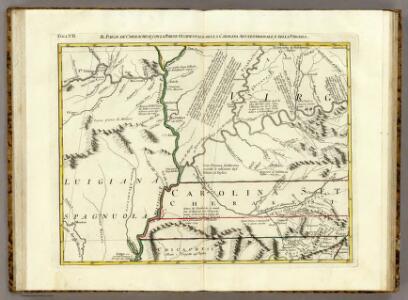
Il Paese de' Cherachesi, con la Parte Occidentale della Carolina Settentrionale.
1 : 2100000 Zatta, Antonio
AutoTrails Map, Missouri, Arkansas, Kentucky, Tennessee.
1 : 1626000 Rand McNally and Company
Map of the south western part of the United States
1 : 5300000 Virtue, Yorston & Co.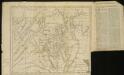
A New map of the province of Maryland in North America
1 : 1170000 Hinton, John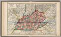
Kentucky and Tennessee,
1 : 2150000 Schonberg & Co.
County map of Kentucky and Tennessee.
from Mitchell's new general atlas, containing maps of the various countries of the world, plans of cities, etc., embraced in fifty-three quarto maps., forming a series of eighty four maps and plans, together with valuable statistical tables.
E. United States 6.
1 : 1774080 Letts, Son & Co.
Kentucky.
from Carey's general atlas, improved and enlarged : being a collection of maps of the world and quarters, their principal empires, kingdoms, &c.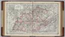
Kentucky and Tennessee.
1 : 1500000 Colton, G.W.
Map of the Tennessee Government.
1 : 3294720 Morse, Jedidiah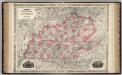
Kentucky And Tennessee.
1 : 1518000 Johnson, A.J.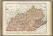
Kentucky, Tennessee.
1 : 1180000 Rand McNally and Company
Kentucky and Tennessee.
1 : 1860000 Colton, G.W.
Missouri, Ill., Ky., Tenn., Ala., Miss., Ark.
1 : 1770000 Society for the Diffusion of Useful Knowledge (Great Britain)
Kentucky, Tennessee.
1 : 1490000 Finley, Anthony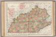
Kentucky, Tennessee.
1 : 1140000 Rand McNally and Company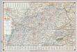
Shell Highway Map of Kentucky, Tennessee.
Shell Oil Company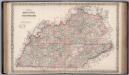
Kentucky and Tennessee.
1 : 1267000 Colton, G.W.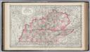
Kentucky and Tennessee.
1 : 1500000 Colton, G.W.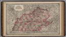
Kentucky and Tennessee.
1 : 1500000 Colton, G.W.
Illinois And Missouri.
1 : 1140480 Tanner, Henry S.
Neueste Karte von Missouri
Grosser Hand-Atlas über alle Theile der Erde in 170 Karten Meyer, J. Verlag des Bibliographischen Instituts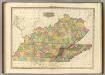
Kentucky And Tennessee.
1 : 1140480 Tanner, Henry S.
[Neueste Karte von Illionois mit seinen Strassen, Entfernungen der Hauptpunkte und Routen für Dampfschiffe]
Grosser Hand-Atlas über alle Theile der Erde in 170 Karten Meyer, J. Verlag des Bibliographischen Instituts
Kentucky & Tennessee.
1 : 1270000 Asher & Adams
Missouri and Arkansas.
1 : 2450000 Black, Adam & Charles
Illinois And Missouri.
1 : 1140480 Tanner, Henry S.
Map of the States of Illinois & Missouri.
1 : 1520640 Beck, Lewis C.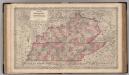
Kentucky and Tennessee.
1 : 1500000 Colton, G.W.