Maps of Piedmont
Chart, extending from 40|15' N. , 72|15' W. to 22|35" N., 80|25' W.
1 : 950000 Hooker, William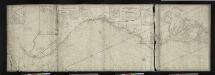
A new and accurate chart (from Captain Holland's surveys) of the North American Coast, for the navigation between Cape Cod in New England and the Havanna in the Gulf of Florida / respectfully inscribed to His Excellency Thomas Jefferson, president of the
from Charts and maps
Virginia and Maryland.
from An epitome of Mr. John Speed's Theatre of the empire of Great Britain, and of his Prospect of the most famous parts of the world : in this new edition are added, the descriptions of His Majesties dominions abroad, viz. New England, New York, ... Carolina, Florida, ... Virginia, Maryland, ... Jamaica, Barbados, ... as also the empire of the Great Mogol, with the rest of the East Indies, ... the empire of Russia, with their respective descriptions.
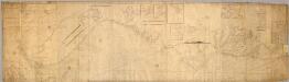
To the members of the Nautical Institution and Ship-masters' Society of the city of New York, this chart, extending from lat. 40o 15' N., long. 72o 15' W., to lat. 22o 35' N., long. 80o 25' W., is respectfully dedicated / by their obedient servant Edmund M. Blunt; plans engraved by Hooker, N. York.
from Charts and maps Hooker, William; Edmund M. Blunt,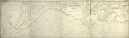
A chart of the coast of America: from New York and Philadelphia to the Strait or Gulf of Florida, and from thence to the Mississippi / a new edition corrected & improved by J.W. Norie, hydrographer, &c., 1837.
from Charts and maps J. W. Norie,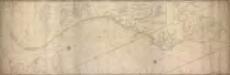
A new and accurate chart (from Captain Holland's surveys) of the North American Coast, for the navigation between Philadelphia and Florida respectfully inscribed to His Excellency Thomas Jefferson, president of the United States of North America / by his most obedient humble servants, Rob[er]t Laurie and Ja[me]s Whittle.
from Charts and maps Robert Laurie; James Whittle,
Vereinigte Staaten Von Nord-Amerika In 6 Blattern, Bl. 6.
1 : 3700000 Petermann, A.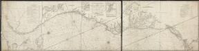
A new and accurate chart (from Captain Holland's surveys) of the North American coast, for the navigation between Cape Cod in New England, and the Havanna in the Gulf of Florida
1 : 765000 Laurie & Whittle Laurie & Whittle
Piedmont Air Line.
1 : 11900000 Piedmont Air Line Railroad Company
A map of Virginia and Maryland.
from Parts
Map of the States of Virginia, North Carolina, South Carolina and Georgia.
1 : 6336000 Morse, Jedidiah
Lloyd's Map of the Southern States
Lloyd's Map of the Southern States showing all the Railroads, their Stations and Distances, also the Counties, Towns, Villages, Harbors, Rivers & Forts. This map was published by J.T. Lloyd in New York in 1861. It details ‘all the railroads, their stations & distances’, as well as the ‘counties, towns, villages, harbors, rivers and forts’ based on the ‘latest Government and other reliable sources’. The map details states beneath the Mason-Dixon line which theoretically separated the northern and southern states. As well as showing the states that made up the eastern side of the Confederacy, the map also shows the Union states of Kentucky, Maryland and Delaware, which, along with Missouri, made up the Border States. Maintaining these states within the Union was a crucial war aim for Lincoln. J.T. Lloyd

United States.
1 : 3380000 Sharpe, J.
The marches of Lord Cornwallis in the Southern Provinces : now States of North America, comprehending the two Carolinas, with Virginia and Maryland, and the Delaware counties / by William Faden, geographer to the King.
from Charts and maps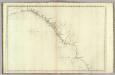
The coast of the United States from New York to St. Augustine (4th sheet)
1 : 900000 Blunt, Edmund M. (Edmund March), 1770-1862
A map of those parts of Virginia, North Carolina, South Carolina & Georgia which were the scenes of the most important operations of the southern armies
from Parts
[Die Vereinigten Staaten von Amerika in 6 Blättern, Blatt 6]
Adolf Stieler's Handatlas über alle Theile der Erde und über das Weltgebäude Stieler, Adolf Justus Perthes
[Die Vereinigten Staaten von Nord-Amerika, Blatt 6]
Handatlas über alle Theile der Erde und über das Weltgebäude Stieler, Adolf Justus Perthes
Nordost-Staaten der Union.
1 : 5000000 Andree, Richard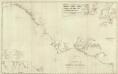
Composite: U.S. coast N.Y. to St. Augustine.
1 : 900000 Blunt, Edmund M. (Edmund March), 1770-1862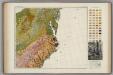
Soil Map of the United States, Section 8. Atlas of American Agriculture.
1 : 2500000 Marbut, Curtis F.
Virginiae partis australis, et Floridae partis orientalis, interjacentiumque regionum Nova Descriptio. [Karte], in: Novus atlas absolutissimus, Bd. 6, S. 210.
1 Karte aus Atlas Janssonius Offizin
[Map of Virginia, North Carolina, and South Carolina].
from Aussführlich, und umständlicher Bericht von der berühmten Landschafft Carolina : in dem engelländischen America gelegen / an Tag gegeben von Kocherthalern.
Virginiae Item et Floridae Americae Provinciarum, nova Descriptio. [Karte], in: Gerardi Mercatoris Atlas, sive, Cosmographicae meditationes de fabrica mundi et fabricati figura, S. 553.
1 Karte aus Atlas Mercator, Gerhard Montanus, Petrus
County map of North Carolina, Map of South Carolina, County map of Florida ; Map of Charleston Harbor [inset].
from New general atlas.
A map of the country between Albemarle Sound and Lake Erie : comprehending the whole of Virginia, Maryland, Delaware and Pennsylvania, with parts of several other of the United States of America / engraved by S. J. Neele, No. 352 Strand, London.
from Notes on the state of Virginia; written in the year 1781, somewhat corrected and enlarged in the winter of 1782, for the use of a foreigner of distinction, in answer to certain queries proposed by him ...
Virginiae partis australis, et Floridae partis orientalis, interiacentiumque regionum Nova Descriptio. [Karte], in: Novus Atlas, das ist, Weltbeschreibung, Bd. 2, S. 328.
1 Karte aus Atlas Blaeu, Joan Blaeu, Willem Janszoon
Virginiae partis australis, et Floridae partis orientalis, interiacentiumque regionum Nova Descriptio. [Karte], in: Le théâtre du monde, ou, Nouvel atlas contenant les chartes et descriptions de tous les païs de la terre, Bd. 2, S. 321.
1 Karte aus Atlas Blaeu, Willem Janszoon und Blaeu, Joan Blaeu, Willem Janszoon


