Maps of United States

Continental Map Of North America.
1 : 3041280 Monk, Jacob
Standard American Map.
1 : 3168000 Monk, Jacob
Special -Karte der Vereinigten Staaten von Nord - America No 16.

Map of the United States of America, the British provinces, Mexico, the West Indies and Central America, with part of New Granada and Venezuela / map drawn by Geo. W. Colton ; engraved by John M. Atwood ; border desig'd. & eng'd. by W. S. Barnard.
from Parts
Map Of The United States The British Provinces Mexico &c.
1 : 14000000 Colton, J. H.
Map of The United States, and Territories. Together with Canada & c. ; Island of Newfoundland
from Atlas of Schuyler County, New York : from actual surveys by and under the direction of Beach Nichols.
United States, Mexico, Central America, Caribbean.
1 : 1584000 Smith, J. Calvin
Charte von Nordamerica
1 Karte : Kupferdruck ; 57 x 50 cm Reichard im Verlage des Industrie Comptoirs
Charte von Nord-America
1 : 20500000 Severní Amerika
CHARTE von NORD-AMERICA
1 : 20500000 Severní Amerika
Map of The United States
from Atlas of Wayne County, New York : from actual surveys and official records / compiled & published by D. G. Beers & Co.
A new and correct map of North America with the West India Islands : divided according to the last treaty of peace, concluded at Paris, 10th Feby. 1763 ; wherein are particularly distinguished, the several provinces and colonies, which compose the Britis
from Whole
A map of North America with the European settlements & whatever else is remarkable in ye West Indies from the latest and best observations / R.W. Seale delin. et sculp.
from Whole R.W. Seale,
[Vereinigte Staaten von Nord-Amerika]
Hypsometrischer Atlas Ziegler, Jakob Melchior Topogr. Anstalt v. J. Wurster u. Comp.
Central America.
1 : 16600000 Sharpe, J.
America, about 1670.
1 : 65000000 Wit, Frederik de
Map of The United States of America
from Atlas of Steuben County, New York : from actual surveys and official records / compiled & published by D.G. Beers & Co.
America septentrionalis
Severní Amerika Janssonius, Johannes excudit Ioannes Ianßonius
A new and correct map of North America with the West India Islands : divided according to the last Treaty of Peace, concluded at Paris the 20th of Jan. 1783, wherein are particularly distinguished the thirteen provinces wich [sic] compose the United Stat
from Charts and maps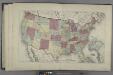
Map of the United States
from Atlas of Madison County, New York : from actual surveys / by and under the direction of D. G. Beers.
A map of North America: with the European settlements & whatever else is remarkable in ye West Indies, from the latest and best observations / R.W. Seale, delin. et sculp.
from Whole R.W. Seale,
Map of the United States of America, the British provinces, Mexico, the West Indies and Central America, with part of New Granada and Venezuela / map drawn by Geo. W. Colton ; engraved by John M. Atwood ; border desig'd. & eng'd. by W. S. Barnard.
From Parts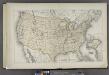
Map of the United States
from County atlas of Cayuga, New York. From recent and actual surveys and records under the superintendence of F. W. Beers.
194-195. United States of America. The World Atlas.
1 : 10000000 USSR (Union of Soviet Socialist Republics).
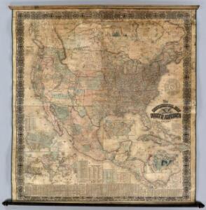
Map of the United States of America, the British Provinces, Mexico, the West Indies and Central America, with part of New Granada and Venezuela
1 : 6400000 Colton, George Woolworth Colton, J. H. (Joseph Hutchins)
Ethnographische Karte von Nordamerika
Zweiter Band, enthaltend in vier Abtheilungen die Vertheilung der Organismen: 5. Pflanzen-Geographie, 6. Thier-Geographie, 7. Anthropographie, 8. Ethnographie Humboldt, Alexander von Verlag von Justus Perthes
Map Of The United States, Canada, Mexico, Central America, West Indies, &c.
1 : 3380000 Williams, G. Washington.
地理志略:北亞美麗加
地理志略 1903年,Alice S. Parker 此为用厦门闽南方言表述、罗马拼音书写的世界地理介绍性著作,介绍了清朝地理和世界六大洲地理概况。内有《大清國》图和《十八省》图,分别为全清和内地省级行政区划图。 2图,彩色,厦门方言罗马拼音,19.8 x 22.8 cm Harvard-Yenching | Rare Book | TA 2380 68.1,Hollis Number:008161909
Map Of The United States Of America.
1 : 16526080 Colton, J. H.