Maps of Gallia County

Maps of Gallia County

$title$

Upper Ohio River and Valley part XVI, 272 to 293 miles below Pittsburgh ... (with) Bladensburg, Chambersburg, Crown City, Gallia Co. O.

1 : 31680 Hayes, Eli L.
$title$

Apple Grove

1 : 24000
$title$

Glenwood

1 : 62500
$title$

Glenwood

1 : 62500
$title$

Glenwood

1 : 62500
$title$

Glenwood

1 : 62500
$title$

Glenwood

1 : 24000
$title$

Glenwood

1 : 24000
$title$

Glenwood

1 : 24000
$title$

Glenwood

1 : 24000
$title$

Glenwood

1 : 24000
$title$

Mercerville

1 : 24000
$title$

Mercerville

1 : 24000
$title$

Mercerville

1 : 24000
$title$

Mercerville

1 : 24000
$title$

Athalia

1 : 24000
$title$

Athalia

1 : 24000
$title$

Athalia

1 : 24000
$title$

Athalia

1 : 24000
$title$

Athalia

1 : 24000
$title$

Athalia

1 : 24000
$title$

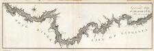
A General Map of the River Ohio, Plate the second.

1 : 316800 Tardieu, P.F.
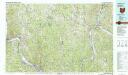
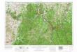
$title$

Ironton

1 : 100000
$title$

Athalia

1 : 62500
$title$

Athalia

1 : 62500
$title$

Athalia

1 : 62500
$title$

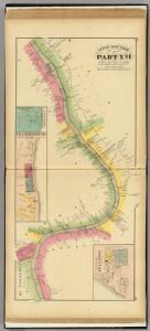
Gallia, Jackson, Lawrence, Meigs, and Vinton counties.

1 : 300000 Walling, H. F.
$title$

Huntington

1 : 250000
$title$

Huntington

1 : 250000
$title$

Huntington

1 : 250000
$title$

Huntington

1 : 250000
© MapTiler © OpenStreetMap contributors
How does it work?
These instructions will show you how to find historical maps online.
Getting started
Type the place name in the search box to find the exact location. You can further adjust the search by zooming in and out.
Zoom
Zoom in and out with the buttons or use your mouse or touchpad natively.
Exact Area tool
Click here and draw a rectangle over the map to precisely define the search area.
Set filters
Narrow your search with advanced settings, such as Years (from/to), Fulltext, Publisher, etc.
Results
See the results of your search on the right side. You can scroll down to find more maps of this location.
?

Download OldMapsOnline Mobile