Maps of England

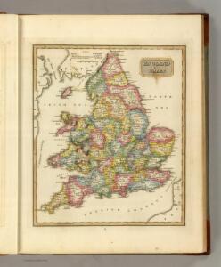
England and Wales.
1 : 2700000 Lucas, Fielding Jr.
County Map Of England, And Wales.
1 : 2400000 Mitchell, Samuel Augustus
England And Wales.
1 : 2850000 Finley, Anthony
England, Wales.
1 : 1800000 Flemming, Carl
Geological map of England and Wales / publ. under the superintendence of the Society for the Diffusion of Useful Knowledge ; arr. by Roderick Impey Murchison ; S.P. Woodward del.; cold. by T. Malby; J. & C. Walker sculpt
1 : 1780000 Annotatie: Oorspr. uitg.: Strand : Chapman and Hall, 1843; Annotatie geografische gegevens: Met aanvullingen tot 1847 Roderick Impey Murchison 1792-1871; S.P. Woodward; T. Malby; Society for the Diffusion of Useful Knowledge London : Knight
Le royaume d'Angleterre
1 Karte : Kupferdruck ; 55 x 47 cm Le Rouge; Basset; Basset chez Basset rue St. Jacques
Le royaume d'Angleterre
1 Karte : Kupferdruck ; 55 x 47 cm Le Rouge; Basset; Basset chez Basset rue St. Jacques
Britanniæ sive Angliæ regnum
1 Karte : Kupferdruck ; 56 x 48 cm Lotter Tobias Konrad Lotter
Le royaume d'Angleterre
1 Karte : Kupferdruck ; 55 x 47 cm Le Rouge Georges Louis Le Rouge rue des Augustins
Britanniæ sive Angliæ regnum
1 Karte : Kupferdruck ; 56 x 48 cm Seutter Matthäus Seutter
Anglia Cambdeni
1 Karte : Kupferdruck ; 38 x 32 cm Camden; Weigel; Kauffer Christoph Weigel
Magnæ Britanniae pars meridionalis, in qua regnum Angliæ
1 Karte : Kupferdruck ; 55 x 47 cm Homann; Visscher Johann Baptist Homann
Nouvelle carte de l'Angleterre
1 Karte : Kupferdruck ; 45 x 47 cm, Gesamtgrösse 45 x 63 cm Châtelain s.n.
Anglia in septem anglo-saxonum regna
1 Karte : Kupferdruck ; 53 x 47 cm Schenk Pieter Schenk
A new mapp of the kingdome of England
1 Karte : Kupferdruck ; 57 x 50 cm printed and given out by Nicolas Visscher upon the Dam at the signe of the fisher, by Iohn Overton at the white horse without Newgate
A new mapp of the kingdome of England
1 Karte : Kupferdruck ; 57 x 50 cm printed and given out by Nicolas Visscher upon the Dam at the signe of the fisher, by Iohn Overton at the white horse without Newgate
Anglia regnum in omnes suos ducatus, comitatus, et provincias divisum
1 Karte : Kupferdruck ; 57 x 48 cm Wit Frederick de Wit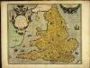
Angliæ regni florentissimi nova descriptio
1 Karte : Kupferdruck ; 38 x 45 cm Lhuyd; Ortelius s.n.
Angliæ regni florentissimi nova descriptio
1 Karte : Kupferdruck ; 38 x 45 cm Ortelius; Lhuyd s.n.

England and Wales.
1 : 1725000 Teesdale, Henry
England.
1 : 2800000 Tanner, Henry S.
Composite: England and Wales.
1 : 900000 Hughes, William
A new and correct map of the roads in England and Wales wherein are contained all the road waies and the principal cross roads, with the computed distances [...] &c.
1 : 1300000 ingraven by Sutton Nicholls London : printed and sold by H. Overton at the White Horse without Newgate
Smith's new map of England and Wales with parts of Scotland : including the turnpike, and principal crossroads ... / engraved by Edw[ar]d Jones & Benj[ami]n Smith
1 : 1275000 Jones, Edward (fl. 1806); Smith, Benjamin London : C. Smith
England.
1 : 1760000 Mitchell, Samuel Augustus
England.
1 : 1760000 Mitchell, Samuel Augustus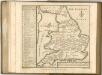

[Recto], uit: England and Wales
1 : 1108000 [London] : Philip [etc.]