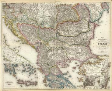
Maps of Balkan Pen.

Composite: Europ. Turkey.
1 : 1740000 Grassl, J. (Joseph)
Neueste Special & Kriegs-Karte der europäischen Türkey in IV Blättern
1 : 1760000 Bospor (Turecko : průliv) Grässl, Joseph Schleifmann, H.
Charte vom Türkischen Reiche in Europa
1 : 3400000 Balkánský poloostrov Reinecke, Johann Christoph Matthias im Verlage des Geogr. Instituts
Charte vom Türkischen Reiche in Europa : nach den neuesten astronomischen Ortsbestim[m]ungen entworfen und berichtiget auf der Sternwarte Seeberg bey Gotha
1 : 3500000 Reinecke, J. C. M. (Johann Christoph Matthias), 1770-1818 Verlag des Industrie-Comptoirs
Ost-Europa, No. 5: Sud-West-Russland & die Turkei.
1 : 3700000 Petermann, A.
Charte vom Türkischen Reiche in Europa
1 : 3400000 Balkánský poloostrov Reinecke, Johann Christoph Matthias im Verlage des Industrie Comptoirs
Charte vom Türkischen Reiche in Europa / nach den neuesten astronomischen Ortsbestimmungen entworfe
1 : 3500000 1 Karte : Kupferdruck ; 46 x 45 cm Reinecke, Johann Matthias Christoph Verlag des Geogr. Instituts
Sedes belli Christianos inter & Turcas, seu tota Hvngaria & Graecia cum vicinis exparte regnis
1 : 5600000 Maďarsko
Südost -Europa
1 : 2000000 Evropa jihovýchodní Peucker, Karl Artaria
Turkischen Reiche in Europa.
1 : 6500000 Haller von Hallerstein, Friedrich
75-76. Penisola balcanica.
1 : 3000000 Touring club italiano
Karte der Balkan Halbinsel
1 : 3000000 Balkánský poloostrov Schlachter, J. J. Schlachter
Karte von dem Türkischen Reiche in Europa
Neuester Schul-Atlas Walch, Johann im Verlag bei Joh. Walch
A general map of Turkey in Europe, Hungary &c
1 : 7400000 Evropa jihovýchodní Moll, Herman H. Moll
Tabula Europae IX. [Karte], in: Geographia universalis vetus et nova complectens Claudii Ptolemaei Alexandrini enarrationis libros VIII, S. 248.
1 Karte aus Atlas Münster, Sebastian [und Ptolemaeus, Claudius]
Nona Europe Tabula [Iazyges Metanastes, Datia, Misia Infer. Misia Superior, Dardania, Tracia] [Karte], in: Claudii Ptolemei viri Alexandrini mathematice discipline philosophi doctissimi geographie opus [...], S. 175.
1 Karte aus Atlas Waldseemüller, Martin [und Ptolemaeus, Claudius] Übelin, Georg
Die Transhumanz der dakorumänischen, aromunischen, meglenorumänischen und istrorumänischen Hirten
Balkanhalbinsel Transhumanz, Walachen Willing, P.
Balkan Halbinsel
1 : 1250000 Balkánský poloostrov
Die Europäische Türkey, Griechenland, Dalmatien und die Republik Montenegro
Schul-Atlas in 36 Karten Völter, Daniel Verlag der J.M. Dannheimer'schen Buchhandlung
Turkey
1 : 6437376 Shows the Balkan Peninsula Relief shown by landforms. Language: English Place of publication not identified : publisher not identified
Das Osmanische Reich in Europa
1 : 925000 Evropa jihovýchodní Danielow, Iwan Mollo, Tranquillo Tranquillo Mollo
Carte de la Turkie d'Europe
1 : 3600000 Evropa jihovýchodní Lapie, Pierre Arnoul Firmin Didot
Nova totius Hungariae, Transilvaniae, Serviae, Romaniae, Bulgariae, Walachiae, Moldaviae, Sclavoniae, Croatiae, Bosniae, Dalmatiae, maximaeq[ue] partis Danubii fluminis, descriptio / emendata a F. de Wit
1 : 2600000 Annotatie: Tekst impressum in het Nederlands; Rechtsboven: 21; Kaart toont Hongarije, omliggende landen en een belangrijk deel van de loop van de Donau; Origineel is Blad 129 in atlas factice; Annotatie geografische gegevens: Schaalstok linksonder cartouche: Milliaria Germanica communia 15 uni gradui = Gemeene Duytsche Mylen van 15 in een graedt Frederick de Wit 1630-1706 Amsterdam : gedruckt by Frederick de Wit inde Kalverstraet by den Dam inde Witte Pascaert
Types des maisons
1 : 6000000 Balkanhalbinsel Südosteuropa Haus
Formes de la propriété rurale
1 : 6000000 Balkanhalbinsel Südosteuropa Grundeigentum
Das osmanische Europa oder die europaeische Türkey
1 : 3000000 Evropa jihovýchodní Weiland, Karl Ferdinand Jungmann, Carl Geograph. Institut
Types des villages
1 : 6000000 Balkanhalbinsel Südosteuropa Ländliche Siedlung
Estats de l'Empire des Turqs en Europe
1 : 4190000 Evropa jihovýchodní Sanson, Guillaume Schenk, Pieter Pierre Schenk
[Ost-Europa in 6 Blättern, Blatt 5]
Handatlas über alle Theile der Erde und über das Weltgebäude Stieler, Adolf Justus Perthes