Maps of Mittelsachsen

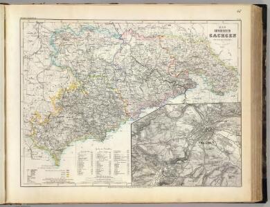
Sachsen.
1 : 540000 Radefeld, Carl Christian Franz, 1788-1874
Generální mapa ČSR
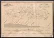
Grundriss und Profil der Chemnitz Riesaer Eisenbahn
1 : 120000 Lippe Lith. Anstalt von H. Jahn
Müllerova mapa Čech
1 : 132000
Die Verschiebung der nationalen Schichtung der Bevölkerung in Nordwest-Böhmen von 1880 bis 1930
Čechy severozápadní (Česko) Deutscher Kulturverband
Accurate geographische Delineation derer zu den Erzgebürgischen Kreisse des Chur Fürstenthums Sachsen gehoerigen Aemmtern I. Kreiss Ammt Freyberg II. Frauenstein III. Altenberg und IV. Lauterstein auch andern angrenzenden Aemmtern und Gegenden
1 : 119000 Altenberg (Sasko, Německo) Schenk, Pieter Lotter, Tobias Conrad P. Schenk

Generalkarte der Bezirkshauptmannschaft Komotau
1 : 220000 Chomutov-oblast (Česko) Wagner, Jan Eduard F. Kytka
Generalkarte der Bezirkshauptmannschaft Komotau
1 : 220000 Chomutov-oblast (Česko) Wagner, Jan Eduard F. Kytka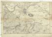
Dresden
1 : 100000 Drážďany-oblast (Německo)
Der Erzgebirgische Kreis
1 : 30000 Chemnitz-oblast (Německo) Riedig, Christian G. Leutemann, H. Schreibers Erben
Charte vom Saatzer Kreise des Königreichs Böheim
1 : 240000 Žatec-oblast (Louny, Česko) Kreibich, František Jakub Jindřich C. W. Enders
Charte vom Saatzer Kreise des Königreichs Böheim
1 : 240000 Žatec-oblast (Louny, Česko) Kreibich, František Jakub Jindřich Enders, C. W. C.W. Enders
Charte vom Saatzer Kreise des Königreichs Böheim
1 : 240000 Žatec-oblast (Louny, Česko) Kreibich, František Jakub Jindřich Enders, C. W. C.W. Enders
Charte vom Saatzer Kreise des Königreichs Böheim
1 : 240000 Žatec-oblast (Louny, Česko) Kreibich, František Jakub Jindřich Enders, C. W. C.W. Enders
Charte vom Saatzer Kreise des Königreichs Böheim
1 : 240000 Žatec-oblast (Louny, Česko) Kreibich, František Jakub Jindřich Enders, C. W. C.W. Enders
Charte vom Saatzer Kreise des Königreichs Böheim
1 : 240000 Žatec-oblast (Louny, Česko) Kreibich, František Jakub Jindřich Rainold, Karl Eduard C.E. Rainold
Charte vom Saatzer Kreise des Königreichs Böheim
1 : 240000 Žatec-oblast (Louny, Česko) Kreibich, František Jakub Jindřich Rainold, Karl Eduard C.E. Rainold
Charte vom Saatzer Kreise des Königreichs Böheim
1 : 240000 Žatec-oblast (Louny, Česko) Kreibich, František Jakub Jindřich C. E. Rainold
Charte vom Saatzer Kreise des Königreichs Böheim
1 : 240000 Žatec-oblast (Louny, Česko) Kreibich, František Jakub Jindřich Rainold, Karl Eduard C.E. Rainold
Charte vom Saatzer Kreise des Königreichs Böheim
1 : 240000 Žatec-oblast (Louny, Česko) Kreibich, František Jakub Jindřich Rainold, Karl Eduard C.E. Rainold
Charte vom Saatzer Kreise des Königreichs Böheim
1 : 240000 Žatec-oblast (Louny, Česko) Kreibich, František Jakub Jindřich C. E. Rainold
Charte vom Saatzer Kreise des Königreichs Böheim
1 : 240000 Žatec-oblast (Louny, Česko) Kreibich, František Jakub Jindřich Rainold, Karl Eduard C.E. Rainold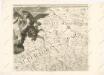
Mappa geographica regni Bohemiae in duodecim circuloc divisae ... Sectio. II.

II. vojenské mapování 6
1 : 144000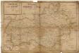
Circulus Satecensis
Žatec-oblast (Louny, Česko) Glocksperger, Johann per Johannem Glocksperger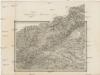
Umgebungen von Kommotau und Saaz
Chomutov-oblast (Česko) Gargani, Ludwig K. u. k. Militärgeographisches Institut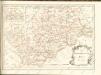

Umgebungen von Kommotau und Saaz
Chomutov-oblast (Česko) Gargani, Ludwig