Maps of Metropolitan France
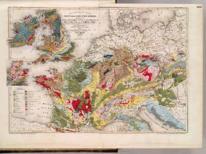
Geognost. Karte, Central- u. West-Europa.
1 : 4070000 Meyer, Joseph, 1796-1856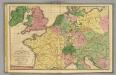
Central Europe.
1 : 4800000 Woodbridge, William C.
Gran carta del teatro della guerra nel 1870
1 : 2340000 Evropa střední Stabilimento civelli
Schul-Atlas für die alte Erdbeschreibung : zur allgemeinen Schul-encyclopädie gehörig
J. H. Campe Zusammensetzung und Zeichnung von [...] Dufour, unter Leitung von Heusinger ; gestochen von Frentzel. Braunschweig : Schulbuchhandlung
Kriegszusammenhänge IV (1740 - 1763)
1 : 15000000 Europa Österreichischer Erbfolgekrieg , Schlesische Kriege
Gallia Germania Britannia
Schul-Atlas der alten Welt bei Justus Perthes
[Historisch-geographischer Atlas zu den allgemeinen Geschichtswerken von C. v. Rotteck, Pölitz u. Becker] : Gallien, Britannien, Germanien und die obern Donau-Länder nach Cæsar, Tacitus, Ptolemæus, Plinius, etc.
von Joh. Val. Kutscheit Lithographie der Herderschen Verlags-Handlung zu Freiburg im Breisg. [Freiburg im Breisgau] : [Herder]
Itineraire-Karte
1 : 6000000 Evropa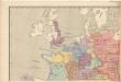
Evropa raného středověku: do konce VI. století po Kr.
Kašpar, Jan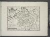
Germany.
from A new sett of maps both of antient and present geography : wherein not only the latitude and longitude of many places are corrected according to the latest observations, but also the most remarkable differences of antient and present geography may be quickly discern'd by a bare inspection or comparing of correspondent maps, which seems to be the most natural and easy method to lead young students (for whose use the work is principally intended) unto a competent knowledge of the geographical science : together with a geographical treatise particularly adapted to the use and design of these maps / by Edward Wells, M.A. and student of Christ-Church, Oxon.
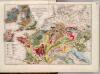
Geognostische Übersichts-Karte von Deutschland, Frankreich, England und den angrenzenden Laendern
Francie Buch, Leopold von Dechen, Heinrich von bei Simon Schropp et Comp.
Rozšíření nejstarší keramiky české v Evropě
Evropa
West- u. Mittel- Europa im Zeitalter Napoleons (bis 1810)
Evropa střední F. Tempsky
Gallia, Britannia, Germania, Provinciae danuvienses.
1 : 5000000 Kiepert, Heinrich, 1818-1899
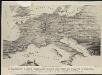
Stannard & Son's, panoramic birds-eye view of France & Prussia and the surrounding countries likely to be involved in the War, with the railways & startegic positions of each army, & the great fortresses of the Rhine provinces
1 : 1
Neueste Eisenbahn-Karte von Central-Europa
1 : 4000000 Evropa střední Issleib & Rietzschel
Orbis Romani, pars occidentalis.
1 : 4300000 Anville, Jean Baptiste Bourguignon d, 1697-1782
Carte des routes de postes de l'Empire francais du royaume d'Italie et de la Confédération du Rhin
Evropa západní Tardieu, Pierre François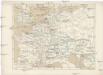
Gallia, Britannia, Rhaetia, Noricum, Pannonia, Germania
Galie
Říše Karla Velikého
Western Europe. Pergamon World Atlas.
1 : 5000000 Polish Army Topography Service
[Geschichtlich-geographischer Atlas von Europa :] X. Karte von Mittel-Europa mit der Provinzial-Eintheilung der verschiedenen Staaten
entworfen und gezeichnet durch Ferd. Aug. v. Witzleben [Berlin etc.] : [Mittler]
Skizzen zu den größeren Manövern der fremden Armeen 1906
Francie Streffleur, Valentin Ritter von L. W. Seidel & Sohn
Übersichtskarte des Eisenbahn- und Telegraphen-Verbindungen von Mittel-Europa
1 : 6170000 Evropa střední Mayer, Alexander
Germania.
from Abraham Ortelius his epitome of the theater of the worlde / nowe latlye ... renewed and augmented ... by Micheal Coignet, mathematitian of Antwarpe.
Orbis Romani pars occidentalis, auspiciis serenissimi principis Ludovici Philippi Aurelianorum ducis publici juris facta
1 : 4300000
Kriegszusammenhänge I (1618 - 1660)
1 : 12000000 Ostmitteleuropa Dreißigjähriger Krieg, Nordischer Krieg <1655-1660>
France, Switzerland, Germany.
Goodrich, S.G.