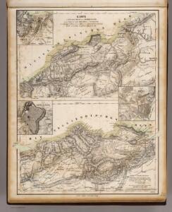
Maps of Mascara

Oran, Constantine.
1 : 800000 Theinert, A.
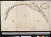
Debaaij van Oran geleegen voor aen in de Middellandse Ze aen de kust van Barbarija
Algeria Gerard van Keulen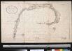
Debaij van Oran geleegen in de Middellandsche Zee aen de kust van Barbarija
Algeria Gerard van Keulen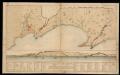
Plano de la Plaza de Oran y sus castillos, con la de Mazalquivir
1 Mapa i 1 Vista. Datació aproximada.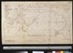
Plano de Oran en desselfs casteel en ook van Marzalquivir
Algeria Johannes van Keulen
Carte des étapes de la province d'Oran
1 : 1000000 E. Corny Alger : A. Jourdan
Maroc (500 000 e). Oudjda
1 : 500000 France. Service géographique de l'armée Service géographique de l'Armée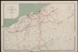
Département d'Oran. Carte des voies de communication
1 : 400000 Calléja; Algérie. Direction de l'agriculture et de la colonisation Alger : lith. Adolphe Jourdan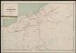
Département d'Oran. Carte des voies de communication
1 : 400000 Calléja; Algérie. Direction de l'agriculture et de la colonisation Alger : lith. Adolphe Jourdan
Algérie
1 : 1600000 Alžírsko Dufour, A. H. Longuet
Dépt D’ Oran carte politique
Vidal de La Blache, Paul
43. Spagna, Portogallo sud.
1 : 1500000 Touring club italiano
Dépt D’ Oran carte physique
Vidal de La Blache, Paul
Granata, Et Murcia Regna. [Karte], in: Novus atlas absolutissimus, Bd. 6, S. 46.
1 Karte aus Atlas Janssonius Offizin
[Spanien und Portugal in 4 Blättern]
Hand-Atlas über alle Theile der Erde und über das Weltgebäude Stieler, Adolf Justus Perthes
[Spanien und Portugal in 4 Blättern]
Hand-Atlas über alle Theile der Erde nach dem neuesten Zustande und über das Weltgebäude Stieler, Adolf bei Justus Perthes
Algeria Colonie Francaise.
1 : 4000000 Levasseur, Victor.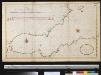
De Middellandsche Zee van Gibralter tot Algiers
Spain Gerard van Keulen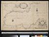
Carte particuliere des côstes d'Espagne et Barbarie depuis Gibralter jusqu'à C. de Palle et depuis Ceuta jusqu'au C. Ferat
Spain Henri Michelot Gerard van Keulen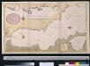
Een gedeelte van de Middelanse Zee van Gibraltar tot Ivica
Spain Gerard van Keulen
Granata, Et Murcia Regna. [Karte], in: Theatrum orbis terrarum, sive, Atlas novus, Bd. 2, S. 234.
1 Karte aus Atlas Blaeu, Joan Blaeu, Willem Janszoon
Granata, Et Murcia Regna. [Karte], in: Gerardi Mercatoris et I. Hondii Newer Atlas, oder, Grosses Weltbuch, Bd. 2, S. 198.
1 Karte aus Atlas Mercator, Gerhard und Hondius, Jodocus Jansson, Jan
Spain, South coast form Gibraltar to Alicante, and north coast of Barbary to cape Ferrat, from Spanish authorities, with corrections by Capt. W.H.Smyth. The north coast of Africa is from French surveys of 1833-55.
Walker, J. & C.
Granata, Et Murcia Regna. [Karte], in: Le théâtre du monde, ou, Nouvel atlas contenant les chartes et descriptions de tous les païs de la terre, Bd. 2, S. 227.
1 Karte aus Atlas Blaeu, Willem Janszoon und Blaeu, Joan Blaeu, Willem Janszoon
Le royaume de Murcie, partie des royaumes de Valence, de Castille Nouvelle, de Grenade [et]c. et l'isle d'Yviça
1 Karte : Kupferdruck ; 44 x 56 cm Jaillot; Dezauche; Cordier chez Dezauche successeur des S.rs De l'Isle et Buache rue des Noyers pres celle des Anglois
Granata, et Mvrcia regna
1 Karte : Kupferdruck ; 36 x 48 cm Janssonius Joannes Janssonius
Granata, et Mvrcia regna
1 Karte : Kupferdruck ; 36 x 48 cm Blaeu Joan Blaeu
Espagne et Portugal. Flle. S.E.
1 : 1250000 Vivien St Martin, L.