Maps of Baden-Württemberg

Wurtemberg.
1 : 555000 Flemming, Carl

Ducatus Wurtenbergensis
1 Karte : Kupferdruck ; 54 x 46 cm Visscher; Schenk; Gouwen nunc apud Pet: Schenk iun
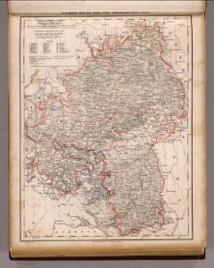
Hydrographische Durchlässigkeitskarte des Königreichs Württemberg
1 : 600000 Regelmann, Carl Giesecke & Devrient
Straßen im Königreich Württemberg 1848
Württemberg Straßennetz Kunz, Andreas ; Treiling, Thomas
Ducatus Wurtenbergici cum locis limitaneis utpote maxima parte circuli Suevici praesertim utroq. marchionatu Badensi et sylva vulgo Nigra
1 : 250000 Bádensko (Německo) Mejer, Johannes Homann, Johann Baptist J. B. Homann
Ducatus Wurtenbergici cum locis limitaneis utpote maxima parte circuli Suevici praesertim utroq. marchionatu Badensi et Sylva vulgo Nigra nova et post omnes exactissima deline[atio]
1 : 250000 Bádensko (Německo) Mejer, Johannes Homann, Johann Baptist Johann Baptist Homann
Ducatus Wirtenbergensis
1 Karte : Kupferdruck ; 45 x 56 cm Danckerts s.n.
Karte vom Königreich Wirtemberg nebst dem Fürstenthum Hohenzollern-Sigmaringen und Sigmaringen
1 : 440000 Sigmaringen (Německo) Walch, Johann Joh. Walch
Karte vom Königreich Wirtemberg nebst dem Fürstenthum Hohenzollern-Sigmaringen
1 : 440000 Württembersko (Německo) Walch, Johann Joh. Walch
Wurtemberg, Baden.
1 : 450000 Weiland, C. F. (Carl Ferdinand), d. 1847
Karte von dem Königreiche Wirtemberg und dem Grosherzogthume Baaden
1 : 787000 Bádensko (Německo)
Wirtenbergensis Ducatus Vera Descriptio, Tubingae Edita. 1558. [Karte], in: Theatrum orbis terrarum, S. 75.
1 Karte aus Atlas Ortelius, Abraham

Les Cours de Postes par le Cercle de Suabe, come ils se presentent dans la Carte Geographique
1 : 130000 Mollova mapová sbírka Homann, Johann Baptist Homann, Johann Baptista - dědici
Special Post Karte durch den schwaebischen Kreis
1 Karte : Kupferdruck ; 43 x 53 cm Homännische Erben
Special Post Karte durch den schwaebischen Kreis
1 Karte : Kupferdruck ; 43 x 54 cm Homännische Erben
Special Post Karte durch den schwaebischen Kreis
1 Karte : Kupferdruck ; 43 x 54 cm Homännische Erben
Ducatus Würtembergiæ circuli imo Suevici pars maxima march.tus et Badensis uterque
1 Karte : Kupferdruck ; 32 x 39 cm Weigel; Kauffer Christoph Weigel
Ducatus Wurtenbergensis
1 : 380000 Mollova mapová sbírka Visscher, Nicolaes Gouwen, Giliam van der Schenk, Peter II
Ducatus Würtenbergici
1 Karte : Kupferdruck ; 47 x 58 cm Majer; Schenk Pieter Schenk
Das Herzogthum Würtemberg
1 Karte : Kupferdruck ; 23 x 30 cm Reilly F. J. J. von Reilly
Ducatus Würtenbergensis
1 : 190000 Mollova mapová sbírka Walther, Johann Georg Walther, Johann Georg
Wirtenberg dvcatvs
1 Karte : Kupferdruck ; 35 x 42 cm Janssonius van Waesbergen; Pitt; Swart apud Janssonio-Waesbergios Mosem Pitt et Stephanum Swart
Wirtenberg dvcatvs
1 : 470000 Württembersko (Německo) Mercator, Gerhard
Wirtenberg dvcatvs
1 Karte : Kupferdruck ; 40 x 48 cm Blaeu; Blaeu Willem und Joan Blaeu
Wirtenberg Ducatus. [Karte], in: Novus atlas absolutissimus, Bd. 2, S. 211.
1 Karte aus Atlas Janssonius Offizin
Wirtenberg dvcatvs
1 : 510000 Annotatie: Origineel is Blad 111 in atlas factice; Linksboven: wapen van Hertogdom Württemberg; Vermelding rechtsboven: XLV; Annotatie geografische gegevens: Schaalvermelding op kaart: Milliaria Germanica communia Johannes Janssonius van Waesberge -1681?; Moses Pitt ca. 1654-1696; Stephanus Swart [Oxford : apud Janssonio-Waesbergios, Mosem Pitt et Stephanum Swart]
Wirtenberg Ducatus [Karte], in: Gerardi Mercatoris et I. Hondii Newer Atlas, oder, Grosses Weltbuch, Bd. 1, S. 230.
1 Karte aus Atlas Mercator, Gerhard und Hondius, Jodocus Jansson, Jan