Maps of Pas-de-Calais
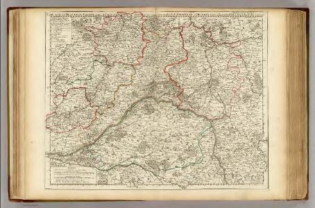
Beauce, Gatinois, Sologne.
1 : 342000 L'Isle, Guillaume de, 1675-1726
Beauce du Gatinois, Sologne.
1 : 342000 L'Isle, Guillaume de, 1675-1726
Zeekusten van Engelant, van't voorlant tot Blackeny, waerin oock is de rivier van London.
from De zee-atlas ofte water-wereld : waer in vertoont werden alle de zee-kusten van het bekende des aerd-bodems : seer dienstigh voor alle heeren en kooplieden, als oock voor alle schippers en stuurlieden / by Pieter Goos.
Flle. 1. Mantes, uit: Carte topographique des environs de Versailles dite "Carte des chasses du Roi"
1 : 28800 titelvariant: Carte des chasses du Roi; Annotatie: Herdruk van originele koperplaten; Oorspr. uitg.: 1764-1807; Voor aanwezige bladen zie overzichtsblad; Annotatie geografische gegevens: Opname: 1764-1773 [Paris : IGN]
Comitatus Flandriae in omnes ejusdem subjacentes ditio[n]es cum adjacentibus acuratißime divisus
1 : 300000 Flandry Homann, Johann Baptist sumtibus Ioh. Bapt. Homanni
Comitatus Flandriae in omnes ejusdem subjacentes ditio[n]es cum adjacentibus acuratißime divisus
1 : 300000 Flandry Homann, Johann Baptist Ioh. Bapt. Homanni
Comitatus Flandriae in omnes ejusdem subjacentes ditio[n]es cum adjacentibus acuratißime divisus
1 : 300000 Flandry Homann, Johann Baptist sumtibus Ioh. Bapt. Homanni
Carte des gouvernements de Flandre françoise, d'Artois, de Picardie et du Boulenois
1 Karte : Kupferdruck ; 42 x 55 cm Bonne; Santini; Remondini chez Mr. Remondini
Flemmings grosse Karte der Westfront - Nordhälfte
1 : 320000 Evropa západní Kettler, Julius Iwan Carl Flemming
Carte de la Picardie, Artois, Boulonois, Flandre françoise, Haynaut et Cambresis, 1
2 Blätter : 62 x 43 cm Bourgoin
Het Nauw van Calais en omgeving (Le Tréport-Oostende)
1 : 750000 Annotatie: Vrijgegeven door W.B.N. (WehrmachtBereich Niederlande?) 26-5 '44; Rechtsonder: K 1148 Den Haag : Kompas
Le Comté d'Artois, et des Environs, ou l'on voit le Ressort du Conseil Provincial d'Artois avec les Frontieres de Picardie
1 : 250000 Mollova mapová sbírka Visscher, Nicolaes Schenk, Pieter Visscher, Nicolaus I.
Nordsee
1 : 150000 Anglie Reichs-Marine-Amt
Carte Particuliere des Environs d'Arthois du Boulenois et d'une Partie de la Picardie
1 : 250000 Mollova mapová sbírka Seutter, Matthäus Lotter, Tobias Conrad Seutter, Matthäus
[110][113] Tabula Comitatus Artesiae, uit: Atlas sive Descriptio terrarum orbis
Annotatie: Gedigitaliseerde versie. Amsterdam. Heiloo : Picturae (vervaardiger), 2015. tiff-bestand. Gedigitaliseerd: 07-01-2015; Origineel: Universiteitsbibliotheek Vrije Universiteit (XL.05127.-) ; Netherlands; Titelpagina ontbreekt Wit, Frederik de Amsterdam : Frederick de Wit
Beauvaisis Comitatus Belovacium. [Karte], in: Novus atlas absolutissimus, Bd. 4, S. 106.
1 Karte aus Atlas Janssonius Offizin
Generalkarte von Zentraleuropa

Nouvelle carte d'Artois et des environs
1 Karte : Kupferdruck ; 47 x 59 cm L'Isle; Husson; Anse chez Pierre Husson
Geographica Artesiae Comitatus tabula / per Nicolaum Visscher edita
1 : 180000 Annotatie: Origineel is Blad 35 in atlas factice; Annotatie geografische gegevens: Met 2 schaalstokken; Legenda Nicolaes Jansz Visscher sr 1618-1679 [Amsterdam : Nicolaes Visscher]
Artois. Atrebatum Regionis Vera Descriptio. [Karte], in: Theatrum orbis terrarum, S. 183.
1 Karte aus Atlas Ortelius, Abraham Vrients, Jan Baptista
Artois. Atrebatum Regionis Vera Descriptio. [Karte], in: Theatrum orbis terrarum, S. 117.
1 Karte aus Atlas Ortelius, Abraham
Carte d'Artois et des environs
1 Karte : Kupferdruck ; 47 x 59 cm L'Isle chez Iean Cóvens et Corneille Mortier
Carte d'Artois, et des environs
1 Karte : Kupferdruck ; 48 x 60 cm L'Isle; Berey chez l'auteur sur le quai de l'Horloge a l'aigle d'or
Artesia cum finitimis locis velut sedes ac theatrum belli
1 Karte : Kupferdruck ; 47 x 56 cm Seutter; L'Isle Matthäus Seutter

Artesia cum finitimis locis velut sedes ac theatrum belli
1 Karte : Kupferdruck ; 48 x 57 cm Lotter; L'Isle Tobias Konrad Lotter
Carte d'Artois et des environs
1 Karte : Kupferdruck ; 47 x 55 cm L'Isle Homännische Erben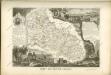
Artesia Comitatus. [Karte], in: Gerardi Mercatoris et I. Hondii Newer Atlas, oder, Grosses Weltbuch, Bd. 1, S. 431.
1 Karte aus Atlas Mercator, Gerhard und Hondius, Jodocus Jansson, Jan
Partie meridionale de Picardie
1 Karte : Kupferdruck ; 47 x 61 cm L'Isle; Buache; Dezauche; Des Rosiers; Lesperon chez Dezauche successeur des S.rs Delisle et Buache rue des Noyers près celle des Anglois