Maps of Lower Saxony
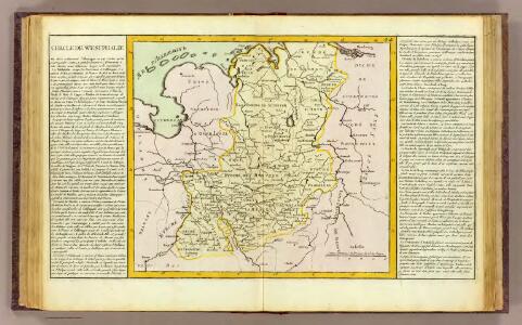
Westphalie.
1 : 1400000 Clouet, J. B. L. (Jean-Baptiste Louis), b. 1730
Operationen der alliirten und französischen Armee 1759
Le Cercle De Westphalie divisé en tous ses Estats et Souverainetés [Karte], in: Atlas nouveau, contenant toutes les parties du monde [...], Bd. 1, S. 295.
1 Karte aus Atlas Sanson, Nicolas Jaillot, Alexis Hubert und Mortier, Pieter
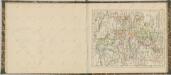
Circulus Westphalicus in suas provincias et ditiones accurate distinctus et recentissime delineat
1 : 1000000 cura et caelo Matth. Seutteri S.C.M.G. G. Matthaeus Seüter jun. sculpsit. Aug. Vind : [Matthäus Seutter]
Circulus Westphaliae cum omnibus suis subjacentibus provinciis novissima delineatio
1 : 1000000 1 Karte : Kupferdruck ; 49 x 56 cm Danckerts, Justus [Danckerts]

Nova et exacta mappa geographica exhibens circulum Westphalicum in omnes suos status et provincias accurate divisum
1 : 700000 Vestfálsko (Německo) Lotter, Tobias Conrad cura et sumptibus Tobiae Conrad Lotter
Nova et exacta mappa geographica exhibens circulum Westphalicum in omnes suos status et provincias accurate divisum
1 : 700000 Vestfálsko (Německo) Lotter, Tobias Conrad Tobiae Conrad Lotter
The north west part of Germany.
1 : 2500000 Moll, Herman, d. 1732
L'Empire, d'Allemagne
1 : 1200000 Mollova mapová sbírka Sanson, Nicolas Quasy, Robert
Postkarte von dem Westphaelischen und Burgundischen Kreise
Burgundsko (Francie) Kühn, Ignaz im von Reilly'schen Landkarten und Kunstwerke Verschleiss Komptoir
Charte über die saemtlichen zum Westphaelischen Kreis gehörige Laender
1 : 840000 Evropa severozápadní Güssefeld, Franz L. bey den Homaennischen Erben
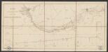
Le Cours de la Riviere du Rhein
1 : 1100000 Mollova mapová sbírka Sanson, Guillaume Schenk, Peter I
Charte über die saemtlichen zum Westphaelischen Kreis gehörige Laender
1 : 834000 Vestfálsko (Německo) Güssefeld, Franz L. Homaenischen Erben
Circulus Westphalicus
1 : 1000000 Mollova mapová sbírka Seutter, Matthäus Seutter, Matthäus
Circulus Westphaliae cum Omnibus Suis Subjacentibus Provinciis Novissima Delineatio
1 : 1000000 Mollova mapová sbírka Ottens, Josua Ottens, Josua

Nordwest-Deutschland
1 : 2000000 Německo severozápadní Kocen, Blaž E. Hölzel
[Vestfálsko a okolí]
Vestfálsko (Německo)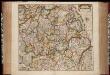
Nova totius Westphaliae descriptio / emendata a F. de Wit
1 : 860000 Annotatie: Origineel is Blad 73 in atlas factice Wit, Frederik de Amsterdam : Frederick de Wit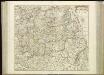
[59][59] Nova totius Westphaliae descriptio, uit: Atlas sive Descriptio terrarum orbis
Annotatie: Gedigitaliseerde versie. Amsterdam. Heiloo : Picturae (vervaardiger), 2015. tiff-bestand. Gedigitaliseerd: 07-01-2015; Origineel: Universiteitsbibliotheek Vrije Universiteit (XL.05127.-) ; Netherlands; Titelpagina ontbreekt Wit, Frederik de Amsterdam : Frederick de Wit
Accuratissima Rheni inferioris Mosae et Mosellae tabula ac minores in eosdem influentes fluvii
1 : 950000 1 Karte : Kupferdruck ; 49 x 57 cm Danckerts, Theodorus [Danckerts]
Bez titulu: Železniční trati v severním Německu

Circuli Westphaliae in omnes suos status et provincias accurate divisi
1 : 700000 Vestfálsko (Německo) Homann, Johann Baptist edita sumtibus Ioh. Baptistae Homann
Circuli Westphaliae in omnes suos status et provincias accurate divisi nova et exacta tabula
1 : 700000 Dolní Sasko (Německo) Homann, Johann Baptist Ioh. Baptistae Homann
Circuli Westphaliae in omnes suos status et provincias accurate divisi
1 : 700000 Vestfálsko (Německo) Homann, Johann Baptist edita sumtibus Ioh. Baptistae Homann
Circuli Westphaliae in omnes suos status et provincias accurate divisi
1 : 700000 Vestfálsko (Německo) Homann, Johann Baptist edita sumtibus Ioh. Baptistae Homann