Maps of Austria
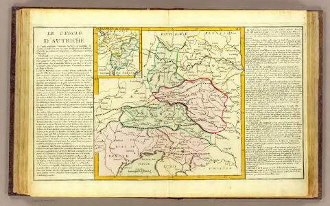
Cercle d'Autriche.
1 : 1450000 Clouet, J. B. L. (Jean-Baptiste Louis), b. 1730
Der oesterreichische Kreis ohne die Vorlande
1 Karte : Kupferdruck ; 50 x 63 cm Mannert in der kais. priv. Kunsthandlung Adam Gottl: Schneider u: Weigel
[Oesterreich]
Neuester Schul-Atlas Walch, Johann im Verlag bei Joh. Walch
Cercle d'Autriche
1 : 1740000 Rakousko Bonne, Rigobert André
[Oesterreich, Tyrol mit Vorarlberg. Steyrmark und Illyrien]
Schul-Atlas in 36 Karten Völter, Daniel Verlag der J.M. Dannheimer'schen Buchhandlung
Teutschlandes Oesterreichischer Creiss
1 : 3700000 Mollova mapová sbírka Weigel, Johann Christoph Weigel, Johann Christoph
Übersichtskarte der evangelischen Kirche Augsb. und Helv. Confession
1 : 864000 Chorvatsko Strehl, Anton k. k. evangel. Oberkirchenrathe
Austria.
1 : 2700000 Bowen, Frances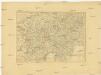
Charte von Oestreich Steyermark, Illyrien und Tyrol
1 : 1600000 Ilýrie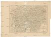
Charte von Oestreich Steyermark Illyrien und Tyrol
1 : 1550000 Ilýrie
Die Ostalpenländer
1 : 2750000 Alpenländer Skizzenbuch
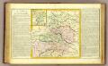
Cercle D'Autriche divisé en toutes ses Provinces, tant Civiles qu'Ecclésiastiques
Brion de la Tour, Louis Desnos
Oestereichischer Kreis
Allgemeiner Atlas [Walch, Johannes] im Verlag bei Johannes Walch
Generalcharte von Oesterreich, Tyrol, Steyermark und Illyrien
1 : 1600000 Horní Rakousko (Rakousko) Schönberg, Johann bey Johann Schönberg
Vetvs Avstria Cisdanvbiana Norica
1 : 2160000 Mollova mapová sbírka Clüver, Philipp Fuhrmann, Mathias
Géographie. croquis n4, Entre Pô et Danube
1 : 1000000 Molard, Jules, Commandant [Paris] : Service Géographique de l'Armée
Haupt Kart Austria
Rakousko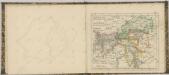

Postkarte von dem oesterreichischen Kreise
Rakousko (1526-1804) Müller, Franz im von Reilly'schen Landkarten und Kunstwerke Verschleiss Komptoir
Postkarte von dem oesterreichischen Kreise
Rakousko (1526-1804) Müller, Franz Reilly'schen Landkarten und Kunstwerke
Karte der Republik Österreich
1 : 1500000 Rakousko Rothaug, Johann Georg Kartogr. Anstalt G. Freytag & Berndt
Süd-Östliches Deutschland
Stieler's Hand-Atlas Stieler, Adolf bei Justus Perthes

[Süd-Östliches Deutschland, Erzherzogth. Oesterreich, Tirol, Illyrien, Steyermark]
Hand-Atlas über alle Theile der Erde nach dem neuesten Zustande und über das Weltgebäude Stieler, Adolf bei Justus Perthes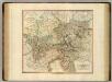
Austria.
1 : 1220000 Cary, John, ca. 1754-1835
[Süd-Östliches Deutschland]
Hand-Atlas über alle Theile der Erde nach dem neuesten Zustande und über das Weltgebäude Stieler, Adolf bei Justus Perthes
Circuli Austriaci
1 : 910000 1 Karte : Kupferdruck ; 48 x 57 cm Danckerts, Justus [Danckerts]
Oesterreich, Süd Westlicher Theil
Handatlas über alle Theile der Erde und über das Weltgebäude Stieler, Adolf Justus Perthes
Autriche, Italie du Nord / P. Bineteau del.
1 : 900000 Bineteau, P. Paris : Taride