Maps of Virginia

Maps of Virginia

$title$

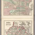
Philadelphia. Virginia and West Virginia.

1 : 1788000 Gray, Ormando Willis
$title$

Der Bundesdistrict Columbia, Virginien, Nord-Carolina, Maryland, u. Delaware.

1 : 3400000 Lange, Henry, 1821-1893.
$title$

Maryland, Virginia, North Carolina, and South Carolina.

1 : 3651000 Fisher, Richard Swainson
$title$

County Map Of Virginia, and North Carolina.

1 : 2800000 Mitchell, Samuel Augustus
$title$

Il Maryland, il Jersey Meridionale, la Delaware.

1 : 2100000 Zatta, Antonio
$title$

Special -Karte der Vereinigten Staaten von Nord - America No 11.

$title$

A new map of Virginia from the best authorities / by T. Kitchin, Geogr.

from London magazine, or, Gentleman's monthly intelligencer (1747)
$title$

County map of Virginia and West Virginia.

from New general atlas.
$title$

Shell Sectional Map No. 3 - Middle Atlantic States.

1 : 1457280 Shell Oil Company
$title$

Virginia.

from Supplement to the New York observer.
$title$

Virginia, North Carolina, South Carolina.

1 : 1584000 Smith, J. Calvin
$title$

Virginia.

1 : 1820000 Colton, G.W.
$title$

The marches of Lord Cornwallis in the southern provinces, now states of North America, comprehending the two Carolinas, with Virginia and Maryland, and the Delaware counties

1 : 1525000 Faden, William Faden, William
$title$

Neueste Karte von Nord Carolina mit seinen Canaelen, Strassen, Eisenbahnen, Entfernungen der Hauptpunkte und Routen für Dampfschiffe

Grosser Hand-Atlas über alle Theile der Erde in 170 Karten Meyer, J. Verlag des Bibliographischen Instituts
$title$

Neueste Karte von Virginia mit seinen Canaelen, Strassen, Eisenbahnen, Entfernungen der Hauptpunkte und Dampfschiff Routen

Grosser Hand-Atlas über alle Theile der Erde in 170 Karten Meyer, J. Verlag des Bibliographischen Instituts
$title$

North Carolina.

1 : 2000000 Colton, G.W.
$title$

North Carolina.

1 : 2000000 Colton, G.W.
$title$

Dela., Md., Va., W. Va., D.C.

1 : 1267200 Asher & Adams
$title$

Virginia, Maryland, and Delaware / by H.S. Tanner.

from Parts
$title$

Virginia.

1 : 4435200 Scott, Joseph
$title$

Virginia, Maryland, and Delaware / by H.S. Tanner.

from Charts and maps
$title$

North Carolina.

1 : 2050000 Colton, G.W.
$title$

North Carolina.

1 : 2600000 Finley, Anthony
$title$

North Carolina.

1 : 2500000 Tanner, Henry S.
$title$

North Carolina.

1 : 2012000 Colton, G. Woolworth
$title$

Il Maryland, il Jersey Meridionale, la Delaware e la parte Orientale della Virginia, e Carolina Settentrionale.

from Charts and maps A. (Antonio) Zatta:[Venezia],
$title$

Composite: Virginia.

1 : 650000 Jefferys, Thomas
$title$

North Carolina.

1 : 2000000 Colton, G.W.
$title$

North Carolina.

1 : 1267000 Colton, G.W.
$title$

Schonberg's Map of Virginia and West Virginia.

1 : 1900000 Schonberg & Co.
© MapTiler © OpenStreetMap contributors
How does it work?
These instructions will show you how to find historical maps online.
Getting started
Type the place name in the search box to find the exact location. You can further adjust the search by zooming in and out.
Zoom
Zoom in and out with the buttons or use your mouse or touchpad natively.
Exact Area tool
Click here and draw a rectangle over the map to precisely define the search area.
Set filters
Narrow your search with advanced settings, such as Years (from/to), Fulltext, Publisher, etc.
Results
See the results of your search on the right side. You can scroll down to find more maps of this location.
?

Download OldMapsOnline Mobile