Maps of Germany

Germany, Austria, and Switzerland.
1 : 4100000 Gray, Ormando Willis
Rozsah moci význačných českých panovníků do XIV. stol.

Neueste Karte vom Deutschen Reich der Oesterreichisch-Ungarischen Monarchie, der Schweiz, den Niederlanden, Belgien, Rumänien, nebst Theilen der angrenzenden Länder.mit besonderer Rücksicht auf Handel & Verkehrs-Interessen sowie zum Hand- und Comptoir-Gebrauch
mapa VKOL Baur, Carl Friedrich A. Hartleben's Verlag
Rozsah moci význačných českých panovníků do XIV. stol.

Composite Map: Map of the Central States of Europe Situate between France and Russia
1 : 1200000 Faden, William (1749-1836)
Europe Centrale.
1 : 3500000 Levasseur, E.
Der Deutsche Bund samt der Helvetischen Eidgenossenschaft aft. 1828
Historisch-genealogisch-geographischer Atlas von Le Sage Las Cases, Emmanuel Auguste Dieudonné Marius Joseph de Johann Velten, Kunsthändler
Neueste Post-Karte von Deutschland und dem grösten Theil der umliegenden Staaten oder Mittel-Europa
1 : 2350000 Evropa střední Fried, Franz List, C. Artaria
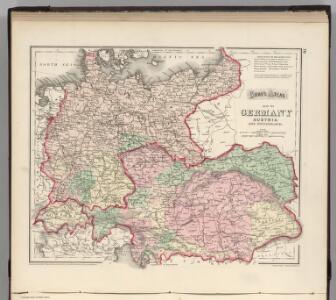
Germany
A new general atlas of modern geography, consisting of a complete collection of maps of the four quarters of the globe Wyld, James James Wyld
Carte Politique de L'Europe Centrale.
1 : 3600000 Jouvet et Cie.
Tabula Moderna Germanie [Karte], in: Claudii Ptolemei viri Alexandrini mathematice discipline philosophi doctissimi geographie opus [...], S. 245.
1 Karte aus Atlas Waldseemüller, Martin [und Ptolemaeus, Claudius] Übelin, Georg
Mitteleuropa
1 : 3500000 Evropa střední Köcher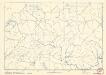
Soubor němých map pro střední školy
Allemagne en 1789.
1 : 3580000 Levasseur, E.
Germany, Austria.
1 : 4118400 Letts, Son & Co.
CARTE de L'ALLEMAGNE POLITIQUE ACTUELLE a partir du CONGRES de VIENNE ou CONFÉDÉRATION GERMANIQUE, renfermant occasionellement la CONFÉDÉRATION SUISSE
Německo Hacq P. Renouard
Übersichtskarte der Eisenbahnen und Eisen-Bahn-Abstoss-Stationen von Mitteleuropa 1883
Evropa střední W. Koch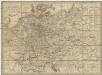
Neueste Post-Karte von Deutschland und demgrösten Theil der umliegenden Staaten oder Mitter-Europa
1 : 2340000 Evropa střední Fried, Franz List, Joseph bey Artaria et Compagnie
Deutsches Reich. Niederlande, Belgien & Schweiz
Adolf Stieler's Handatlas über alle Theile der Erde und über das Weltgebäude Stieler, Adolf Justus Perthes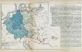
Nr. 8a. Die Germanisierung des Ostens
Ostmitteleuropa Deutsche, Siedlung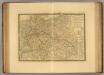
Europe Centrale.
1 : 3500000 Picquet, C.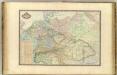
Europe Centrale.
1 : 3000000 Garnier, F. A., 1803-1863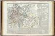
Carta generale della Germania ossia Confederazione Germanica.
1 : 3500000 Marzolla, Benedetto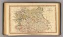
Central states Europe.
1 : 9000000 Fenner, Rest.
Mitteleuropa am Ende des 30 jährigen Krieges
Evropa střední F. Tempsky
L'Allemagne 843 a 911.
1 : 6300000 Houze, Antoine Philippe
Germany general map.
1 : 4300000 Society for the Diffusion of Useful Knowledge (Great Britain)
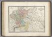
Germany.
1 : 6336000 Finley, Anthony
Germany.
1 : 6336000 Lucas, Fielding Jr.