Maps of Briançon

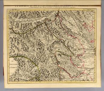
Source du Po, France-Piemont.
1 : 250000 Placide de Sainte Helene, Father
Bailliage d'Enbrun
1 : 250000 Mollova mapová sbírka Placide de Sainte-Hélène Berey, Charles Amadeus de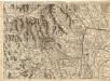
Environs de Suse, et de St. Jean de Morienne.
1 : 240000 Mollova mapová sbírka Dheulland, Guillaume Dheulland, Guillaume
Les Vallées du Piemont
1 : 590000 Mollova mapová sbírka Nolin, Jean-Baptiste Nolin, Jean Baptiste
[Piemontesische Alpen - Gegend nordwestlich von Turin]
Geologischer Atlas zur Naturgeschichte der Erde Leonhard, Carl Cäsar von E. Schweizerbart'sche Verlagsbuchhandlung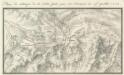
Plan de l'attaque de la Siette faite par les François le 19ieme. Juillet 1747
Mollova mapová sbírka
Carte historique des vallées Vaudoises
1 : 100000 Rochas d'Aiglun, Albert de 1837-1914 Paris : Erhard
[Queyraz]
1 Blatt : 56 x 48 cm s.n.
166 Queyras.
1 : 86400 Cassini family; Cassini, Cesar-Francois, 1714-1784
Carta Topographica da Torino sino a Cuneoconsuoi camini fiumi Torenti et Seoladici
Mollova mapová sbírka
[Kaart], uit: Ciriè
1 : 50000 Torino : G.B. Maggi
Govverneme[n]t d'Embrun
1 Karte : Kupferdruck ; 11 x 15 cm Sebastian Cramoisy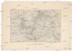
Briançon
1 : 80000 Service géographique de l'armee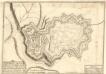
Pignerol :
1 : 6000 Mollova mapová sbírka Loon, Herman van Fer, Nicolas de
Pignerol, ville forte d'Italie en Piemont, située sur une montagne de la vallée de Perouse, a 44. degrez 30. min. de latitude et 20. degr. 5. min. de longitude, acquise par le Roy, sur le Duc de Savoye, en 1630
1 : 6500 [Nicolas de Fer] [Paris] : [Nicolas de Fer]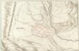
Quillestre. Piemont
Mollova mapová sbírka
Der Pelvoux und seine Umgebungen
1 : 60000 Tuckett, F.F. Liebeskind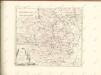

Karte zu Hannibals Alpen-Uebergang
1 : 500000 1 Karte
Le Dauphiné
1 Karte : Kupferdruck ; 50 x 70 cm Dezauche; Jaillot chez Dezauche successeur des S.rs De l'Isle et Buache premiers géographes du roi rue des Noyers pres celle des Anglois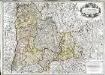
Le Dauphiné
1 Karte : Kupferdruck ; 50 x 71 cm Jaillot chez le Sr. Jaillot joignant les grands Augustins aux deux globes
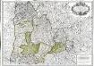
Principaute de Piemont Seigneurie de Verceil Duché ou Val d'Aoust Marquisat d'Ivreé Marquisat de Suse Comté d'Ast, Comté de Tarantaise le Canavesz, Comté de Morienne et la Monferrat
1 : 230000 Mollova mapová sbírka Fer, Nicolas de Guérard, Nicolas Fer, Nicolas de
Grenoble - Turin

Estats du Duc de Savoye de delà des Alpes et vers l'Italie :
1 : 530000 Mollova mapová sbírka Sanson, Nicolas L'Huilier, Jan
36) XII.N.E. ''Turin'', uit: Carte géologique de France
1 : 500000 Annotatie: Voor aanwezige bladen zie bladoverzicht [S.l : s.n.]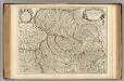
Piedmont, Monferrat.
1 : 275000 L'Isle, Guillaume de, 1675-1726
Carte du Piemonte et du Montferrat
1 : 270000 Mollova mapová sbírka Delisle, Guillaume Liébaux L'Isle, Guillaume de
Stato Del Piemonte [Karte], in: Novus Atlas, das ist, Weltbeschreibung, Bd. 3, S. 44.
1 Karte aus Atlas Blaeu, Joan Blaeu, Willem Janszoon