Maps of Nordrhein-Westfalen

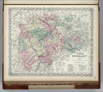
Germany.
1 : 1500000 Colton, G.W.
Germany No. 2.
1 : 1393920 Colton, G.W.
Germany.
1 : 1500000 Colton, G.W.
Germany No. 2.
1 : 1500000 Colton, G.W.
Germany.
1 : 1500000 Colton, G.W.
Germany No.3.
1 : 1375000 Colton, G.W.
Laender zwischen der Maas und der Elbe
1 : 1442000 Labe-oblast (Česko a Německo) Tranquillo Mollo
West Deutschland
Neuer Handatlas über alle Theile der Erde Kiepert, Heinrich Verlag von Dietrich Reimer
III. vojenské mapování 4251/1
1 : 25000
Westdeutsches Mittelgebirge
Plastischer Schul-Atlas über alle Theile der Erde : in 24 Karten Woldermann, G Verlag von P. Eckerlein
Westphalen, Rhein-Privinz, Hessen.
1 : 700000 Weiland, C. F. (Carl Ferdinand), d. 1847
Die königlich preussische Provinz Westphalen und die Rhein-Provinz, uit: General Charte von dem Koenigreiche Sachsen / nach den besten vorhandenen Hilfsmitteln und nach den neuesten äussern und innern Begränzungen des Königreichs entworfen von C.F. Weiland
1 : 300000 titelvariant: Royaume de Saxe, Pays de Saxe, Provinces du Rhin et Hesse Cassel & Darmstadt; Annotatie: In hoesje met opdruk: Royaume de Saxe, Pays de Saxe, Provinces du Rhin et Hesse Cassel & Darmstadt Weiland, C. F. Weimar : im Verlage des Geographischen Instituts
Charte von den Königlich Preussischen Provinzen Westphalen Cleve-Berg und Niederrhein dem Kurfürstenthume Hessen, Grossherzogthume Hessen, dem Herzogth. Nassau Fürstenth. Waldeck und dem Gebiete der freien Stadt Frankfurt
1 : 800000 entworfen von C. F. Weiland Weimar : im Verlage des Geograph. Instituts
[Hannover, Braunschweig, Kurhessen, Gr. Herz. Hessen, Hess. Homburg]
Schul-Atlas in 36 Karten Völter, Daniel Verlag der J.M. Dannheimer'schen Buchhandlung
Postkarte von dem Oberrheinischen, Niederrheinischen und Fraenkischen Kreise
Dolní Porýní (Německo) Müller, Franz im von Reilly'schen Landkarten und Kunstwerke Verschleiss Komptoir
Operationen der alliirten und französischen Armee 1759
Operations-Karte für die Bewegung der alliirten und der ihr gegenüberstehenden Französischen Armee vom 7ten Februar bis 8ten März.
1 : 600000
Rheinprovinz, Westfalen, Hessen-Nassau, Waldeck, Grossherzogthum Hessen.
1 : 1000000 Andree, Richard
Rhenish Prussia, Westphalia, Hesse-Nassau, Waldeck, Lippe, Hesse.
1 : 1000000 Andree, Richard; Times (London, England)
Radfahrer-übersichstkarte von Deutschland

Lower, Upper Rhine, Franconia.
1 : 1750000 Bowen, Frances
Circulus Westphalicus
1 : 1000000 Mollova mapová sbírka Seutter, Matthäus Seutter, Matthäus
Circulus Westphaliae cum Omnibus Suis Subjacentibus Provinciis Novissima Delineatio
1 : 1000000 Mollova mapová sbírka Ottens, Josua Ottens, Josua
Westdeutschland
Volksschul-Atlas über alle Teile der Erde Lange, Henry Druck und Verlag von Georg Westermann
Circulus Westphaliae cum omnibus suis subjacentibus provinciis novissima delineatio
1 : 1000000 1 Karte : Kupferdruck ; 49 x 56 cm Danckerts, Justus [Danckerts]

Die Preussische Provinz Sachsen
1 : 600000 Geographisches Institut (Weimar, Germany)
CIRCULUS WESTPHALICUS IN SUAS PROVINCIAS ET DITIONES accurate distinctus et recentissime delineat
1 : 1100000 Vestfálsko (Německo) Seutter, Matthäus cura et caelo Matth. Seutteri
Circulus Westphalicus in suas provincias et dittiones
1 : 1040000 Vestfálsko (Německo) Seutter, Matthäus cura et caelo Matth. Seutteri