Maps of Weehawken

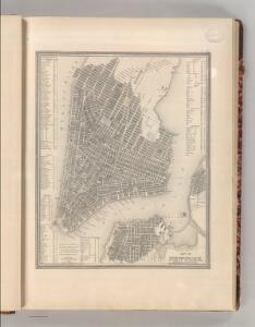
City of New York.
1 : 17000 Tanner, Henry S.
Map of the city of New-York extending northward to Fiftieth St. / surveyed and drawn by John F. Harrison, C.E.
from Manhattan
Map of the City of New-York with part of Brooklyn and Williamsburgh : population in the year 1850: 450,000 inhabitants.
from Manhattan
Map of New York City, south of 46th St. : showing new arrangement of docks, piers, and water frontage, also soundings and former high water line
1 : 7200 Dripps, M. (Matthew) Matthew Dripps
A new map of the city of New York : comprising all the late improvements, compiled and corrected from authentic documents.
from Manhattan
Map of the City of New-York with part of Brooklyn and Williamsburgh : population in the year 1850: 450,000 inhabitants / D. Völker, sc.
from Manhattan
Map of the City of New York.
from Manhattan
Map of the city of New York, shewing the original high water line and the location of the different farms and estates
Common Council
A new map of the city of New York : comprising all the late improvements, compiled and corrected from authentic documents.
from Manhattan
New York (City).
1 : 24000 Goodrich, S.G.
New York.
1 : 24000 Bradford, Thomas G.
Plan von New York
1 : 2000 New York (New York) Bibliographisches Institut
A new map of the city of New York : comprising all the late improvements, compiled and corrected from authentic documents, designed to accompany the Description of New York.
from Manhattan
Strangers guide through the city of New York : with the latest improvements / by H. Phelps.
from Manhattan
Map of the lower section of the city of New York : showing high and low water lines.
From Manhattan
City of New-York
1 : 12500 Burr, David H., 1803-1875 Edward Walker
This actual map and comparative plans showing 88 years growth of the City of New York : is inscribed to the citizens by the proprietor, David Longworth / G.B. King sc. N.Y. 1817 ; engraved by Jas. D. Stout.
from Manhattan
City of New-York / W. Kemble.
from Manhattan
Firemen's guide and map of the city of New-York shewing the boundaries of the proposed new fire districts / enlered according to Act of Congress in the year 1840 by George Hayward
1 Mapa, b/n. Dins (?): Valentine's manual of New York city, 1841-1870 Hayward, George G. Hayward's Lith. G. Hayward's Lith.
Plan von New-York, 1844.
from Manhattan
City of New-York.
1 : 17000 Mitchell, Samuel Augustus
Outline and Index Map of Atlas of New York City.
from Atlas of the borough of Manhattan, city of New York.
Map Of The City Of New York
1 : 12500 Ensign, Bridgman & Fanning
Outline and Index Map of Volume Two, Atlas of New York City, Borough of Manhattan. 14th Street to 59th Street.
from Atlas of the city of New York, borough of Manhattan. From actual surveys and official plans / by George W. and Walter S. Bromley.
Plan von der Stadt New York
1 : 68500 New York (New York)
City of New-York / by David H. Burr.
from Manhattan
Topographical Atlas Of The City Of New York
1 : 12000 Viele, Egbert L.
Plan of the city of New-York : the greater part from actual survey made expressly for the purpose (the rest from authentic documents)
1 : 7300 Poppleton, Thomas H Prior & Dunning
Hooker's new pocket plan of the city of New York / compiled & surveyed by William Hooker, engraver, No. 179 Water Street, New York, house, Willoughby St., Brooklyn.
From Manhattan