Maps of Pontic Steppe

Maps of Pontic Steppe

$title$

S. Russia in Europe.
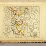
1 : 8900000 Seaman, James V.
$title$

Ruszland, Verbreitung der deutschen Sprache

Russland / Europäischer Teil Sprachverbreitung, Deutsch
$title$

[Východoevropské státy]

Evropa východní
$title$

Von dem künigreich Poland das in Sarmatia auch begriffen wirt

1 : 8600000 1 Karte : Holzschnitt ; Münster, Sebastian [Henricpetri]
$title$

[Východní Evropa]

Evropa východní
$title$

Plan von der Krim und der Nogdyschen und Kubanschen Tatarey

1 : 7420000 Krym (Ukrajina)
$title$

Partie méridionale de la Russie européenne / par le Sr. Robert de Vaugondy fils géographe ordinai

1 : 3400000 1 Karte auf 2 Blatt : Kupferdruck ; 47 x 59 cm Robert de Vaugondy, Didier [Verlag nicht ermittelbar]
$title$

$title$

Imperii Moscovitici pars Australis

1 : 2600000 in lucem edita per G. de l'Isle [...] nunc excusa et venalis exposita per Matthaeum Seutter Augustae Vindelic : Matt. Seutter
$title$

$title$

Südliches Blatt vom Europ. Russland

Hand-Atlas über alle Theile der Erde nach dem neuesten Zustande und über das Weltgebäude Stieler, Adolf bei Justus Perthes
$title$

Russie Europeenne nord.

1 : 3400000 Robert de Vaugondy, Gilles, 1688-1766
$title$

UKRANIA seu COSACORUM Regio Walachia item Moldavia et Tartaria minor

1 : 4600000 Moldávie (historické území) Weigel, Christoph exc. Christ. Weigelio
$title$

Taurica Chersonesus. Nostra aetate Przecopsca et Gazara dicitur [Karte], in: Gerardi Mercatoris Atlas, sive, Cosmographicae meditationes de fabrica mundi et fabricati figura, S. 167.

1 Karte aus Atlas Mercator, Gerhard Montanus, Petrus
$title$

Europ. Russland

Stieler's Hand-Atlas Stieler, Adolf bei Justus Perthes
$title$

Carte hydrographique de la principale partie de la Russia Europeenne

1 : 3000000 Rusko západní Wiebeking, Carl Friedrich von Ranzinger, Jean
$title$

Administrativnaja Karta Evropejskoj časti C.C.C.P.

$title$

Taurica Chersonesus, Nostra aetate Przecopsca, et Gazara dicitur. [Karte], in: Le théâtre du monde, ou, Nouvel atlas contenant les chartes et descriptions de tous les païs de la terre, Bd. 1, S. 80.

1 Karte aus Atlas Blaeu, Willem Janszoon und Blaeu, Joan Blaeu, Willem Janszoon
$title$

La Moscovie meridionale, suivant les nouvelles observations de Messrs. de L'Académie Royale de Scie

1 : 5800000 1 Karte : Kupferdruck ; 21 x 29 cm chez Pierre van der AA
$title$

La Moscovie meridionale, suivant les nouvelles observations de Messrs. de L'Académie Royale de Scie

1 : 5800000 1 Karte : Kupferdruck ; 21 x 29 cm chez Pierre van der AA
$title$

La Moscovie meridionale, suivant les nouvelles observations de Messrs. de L'Académie Royale de Scie

1 : 5800000 1 Karte : Kupferdruck ; 21 x 29 cm chez Covens et Mortier
$title$

La Moscovie meridionale, suivant les nouvelles observations de Messrs. de L'Académie Royale de Scie

1 : 5800000 1 Karte : Kupferdruck ; 21 x 29 cm chez Covens et Mortier
$title$

Nouvelle carte des etats du grand duc de Moscovie en Europe partie meridionale

1 : 3700000 1 Karte : Kupferdruck ; 34 x 45 cm Châtelain, Zacharias [Verlag nicht ermittelbar]
$title$

$title$

Tabvla Asiae II

1 : 7900000 1 Karte : Holzschnitt ; 26 x 33 cm Münster, Sebastian [Bey den Henricpetrinischen]
$title$

$title$

Taurica Chersonesus, Nostra aetate Przecopsca, et Gazara dicitur. [Karte], in: Theatrum orbis terrarum, sive, Atlas novus, Bd. 1, S. 82.

1 Karte aus Atlas Blaeu, Joan Blaeu, Willem Janszoon
$title$

Physische Übersichtskarte der Ukraina und der angrenzenden Länder

1 : 5000000 Ukraine Geologie Kartogr. Anstalt G. Freytag & Berndt, Ges. m. b. H., Wien
$title$

[Europäisches Russland, Südliches Blatt]

Hand-Atlas über alle Theile der Erde nach dem neuesten Zustande und über das Weltgebäude Stieler, Adolf bei Justus Perthes
$title$

Cvmania Magna olim Hvnnia Orientalis

1 : 6500000 Mollova mapová sbírka
© MapTiler © OpenStreetMap contributors
How does it work?
These instructions will show you how to find historical maps online.
Getting started
Type the place name in the search box to find the exact location. You can further adjust the search by zooming in and out.
Zoom
Zoom in and out with the buttons or use your mouse or touchpad natively.
Exact Area tool
Click here and draw a rectangle over the map to precisely define the search area.
Set filters
Narrow your search with advanced settings, such as Years (from/to), Fulltext, Publisher, etc.
Results
See the results of your search on the right side. You can scroll down to find more maps of this location.
?

Download OldMapsOnline Mobile