Maps of Town of North Castle
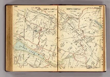
246-247 North Castle.
1 : 21600 G.W. Bromley & Co.
Mount Kisco
1 : 24000
Mount Kisco
1 : 24000
Mount Kisco
1 : 24000
Mount Kisco
1 : 24000
Mount Kisco
1 : 24000
Mount Kisco
1 : 24000
N. Castle, Town.
1 : 47520 Beers, F. W. (Frederick W.)
North Castle town.
1 : 31680 Bien, Joseph Rudolf
10 Atlas rural country district north of New York City.
1 : 18000 Hyde, E. Belcher
Westchester, V. 2, Double Page Plate No. 40 [Map bounded by Part of the Towns of Poundridge, Bedford, North Castle]
From Vol. 2
8. Kensico-Mt. Kisco-Pleasantville-Bedford.
1 : 80000 Servoss, R. D.
8. Kensico-Mt. Kisco-Pleasantville-Bedford.
1 : 80000 Servoss, R. D.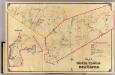
7 North Castle, New Castle.
1 : 18000 Hyde & Company
Town of Bedford, Westchester County, New York.
1 : 38169 Beers, J.B.
Bedford,Town.
1 : 38016 Beers, F. W. (Frederick W.)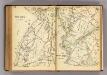
248-249 New Castle, North Castle.
1 : 21600 G.W. Bromley & Co.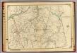
13 Atlas rural country district north of New York City.
1 : 18000 Hyde, E. Belcher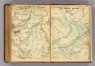
266-267 Bedford, Somers.
1 : 21600 G.W. Bromley & Co.
Plate 14: Vol. 3 of Maps, Page 10. [Bounded by Old Road, Road to Hunt's Point and (Homestead Farms of Thos. Leggett) Leggetts Creek.] - Vol 2. of Maps, Page 28. [Bounded by Bronx River, The Hunt's Point Road and The Westchester Turnpike Road.]
from Certified copies of important maps appertaining to the 23rd and 24th wards, City of New York, filed in the Register's office at White Plains, County of Westchester, New York ...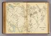
242-243 North Castle.
1 : 21600 G.W. Bromley & Co.
Croton Lake vicinity.
1 : 31680 Vermeule, C. C. (Cornelius Clarkson), 1858-1950
Plate 73: Town of Newcastle, Westchester Co. N.Y.
from County atlas of Westchester, New York. Published by J.B. Beers & Co., assisted by S.W. Wilson and others.
31. Stamford sheet.
1 : 62500 Geological Survey (U.S.)
Westchester, Plate No. 28 [Map of Town of North Castle] / prepared under the direction of Joseph R. Bien, from general surveys and official records.
From Atlas of Westchester County, New York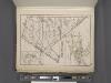
Westchester, Plate No. 29 [Map of Town of New Castle, Village of Mt.Kisco, Village of Chappaqua] / prepared under the direction of Joseph R. Bien, from general surveys and official records.
From Atlas of Westchester County, New York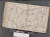
Westchester, Double Page Plate No. 31 [Map of Town of Poundridge, Lewisbord and North Salem] / prepared under the direction of Joseph R. Bien, from general surveys and official records.
From Atlas of Westchester County, New York
Fairfield Co. S.
1 : 72000 D.H. Hurd & Co.
Westchester, Double Page Plate No. 30 [Map of Town of Bedford and Somers] / prepared under the direction of Joseph R. Bien, from general surveys and official records.
From Atlas of Westchester County, New York