Maps of Westchester County
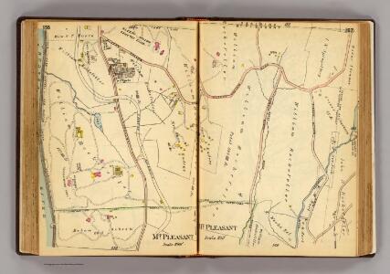
156-157 Mt. Pleasant.
1 : 9600 G.W. Bromley & Co.
Plates 42 & 43: Tarrytown Heights Land Company, Plan of the Land, belonging to the Company.
from County atlas of Westchester, New York. Published by J.B. Beers & Co., assisted by S.W. Wilson and others.
146-147 N. Tarrytown, Mt. Pleasant.
1 : 7200 G.W. Bromley & Co.
E4 Tarrytown, N. Tarrytown.
1 : 9600 Watson & Co. (New York, N.Y.)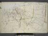
Plan of Tarrytown, North Tarrytown, and Surroundings.
from Atlas of the Hudson River Valley from New York city to Troy, including a section of about 8 miles in width. Published by Watson & co. Compiled from official records and careful surveys, under the supervision of F. W. Beers.
Ossining, Sparta.
1 : 25344 Beers, F. W. (Frederick W.)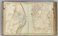
8 Rockland, Westchester counties.
1 : 14400 Watson & Co. (New York, N.Y.)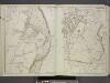
Portion of Rockland County. ; Portion of Westchester County.
from Atlas of the Hudson River Valley from New York city to Troy, including a section of about 8 miles in width. Published by Watson & co. Compiled from official records and careful surveys, under the supervision of F. W. Beers.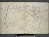
Plan of Sing Sing and part of Town of Ossining.
from Atlas of the Hudson River Valley from New York city to Troy, including a section of about 8 miles in width. Published by Watson & co. Compiled from official records and careful surveys, under the supervision of F. W. Beers.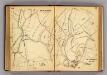
148-149 Mt. Pleasant.
1 : 7200 G.W. Bromley & Co.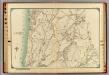
9 Atlas rural country district north of New York City.
1 : 18000 Hyde, E. Belcher
White Plains
1 : 24000
White Plains
1 : 24000
White Plains
1 : 24000
White Plains
1 : 24000
White Plains
1 : 24000
White Plains
1 : 24000
White Plains
1 : 31680
White Plains
1 : 31680
White Plains
1 : 24000
Croton Landing - Sparta.
from County atlas of Westchester, New York. Published by J.B. Beers & Co., assisted by S.W. Wilson and others.
6 Ossining, Mt. Pleasant.
1 : 18000 Hyde & Company
Mt. Pleasant, Town.
1 : 38016 Beers, F. W. (Frederick W.)
North part of Town of Mount Pleasant - Pleasantville.
from County atlas of Westchester, New York. Published by J.B. Beers & Co., assisted by S.W. Wilson and others.
Mt. Pleasant, Ossining towns.
1 : 25700 Bien, Joseph Rudolf
7. Tarrytown-Oscawana-Merritt's Corners.
1 : 80000 Servoss, R. D.
7. Tarrytown-Oscawana-Merritt's Corners.
1 : 80000 Servoss, R. D.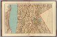
Westchester Co., Irvington-state line.
1 : 31680 Vermeule, C. C. (Cornelius Clarkson), 1858-1950
Westchester, Double Page Plate No. 20 [Map of town of Greenburg] / prepared under the direction of Joseph R. Bien, from general surveys and official records.
From Atlas of Westchester County, New York
Tarrytown
1 : 62500
Tarrytown
1 : 62500
Tarrytown
1 : 62500
Tarrytown
1 : 62500
Tarrytown
1 : 62500
Tarrytown
1 : 62500
Tarrytown
1 : 62500
Tarrytown
1 : 62500
Tarrytown
1 : 62500