Maps of Hawthorne
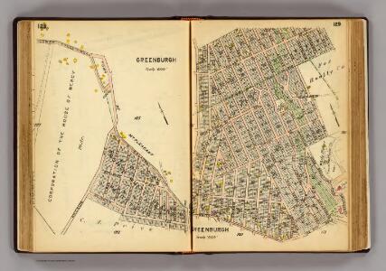
128-129 Greenburgh.
1 : 7200 G.W. Bromley & Co.
160-161 Mt. Pleasant.
1 : 18000 G.W. Bromley & Co.
White Plains
1 : 24000
White Plains
1 : 24000
White Plains
1 : 24000
White Plains
1 : 24000
White Plains
1 : 24000
White Plains
1 : 24000
White Plains
1 : 31680
White Plains
1 : 31680
White Plains
1 : 24000
6 Ossining, Mt. Pleasant.
1 : 18000 Hyde & Company
Mt. Pleasant, Town.
1 : 38016 Beers, F. W. (Frederick W.)
Mt. Pleasant, Ossining.
1 : 24000 Bromley, George Washington; Bromley, Walter Scott; G.W. Bromley & Co.
North part of Town of Mount Pleasant - Pleasantville.
from County atlas of Westchester, New York. Published by J.B. Beers & Co., assisted by S.W. Wilson and others.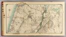
6 Atlas rural country district north of New York City.
1 : 15000 Hyde, E. Belcher
Town of Rye, Westerchester Co. N.Y.
from County atlas of Westchester, New York. Published by J.B. Beers & Co., assisted by S.W. Wilson and others.
Mt. Pleasant, Ossining towns.
1 : 25700 Bien, Joseph Rudolf
8. Kensico-Mt. Kisco-Pleasantville-Bedford.
1 : 80000 Servoss, R. D.
Plate 30: Town of Greenburgh, Westchester Co. N.Y.
from Atlas of New York and vicinity : from actual surveys / by and under the direction of F. W. Beers, assisted by A. B. Prindle & others
Westchester, Double Page Plate No. 20 [Map of town of Greenburg] / prepared under the direction of Joseph R. Bien, from general surveys and official records.
From Atlas of Westchester County, New York
North part of Town of Mount Pleasant - Pleasantville.
from County atlas of Westchester, New York. Published by J.B. Beers & Co., assisted by S.W. Wilson and others.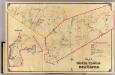
7 North Castle, New Castle.
1 : 18000 Hyde & Company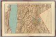
Westchester Co., Irvington-state line.
1 : 31680 Vermeule, C. C. (Cornelius Clarkson), 1858-1950
Tarrytown
1 : 62500
Tarrytown
1 : 62500
Tarrytown
1 : 62500
Tarrytown
1 : 62500
Tarrytown
1 : 62500
Tarrytown
1 : 62500
Tarrytown
1 : 62500
Tarrytown
1 : 62500
Tarrytown
1 : 62500