Maps of Manhattan Community Board 9
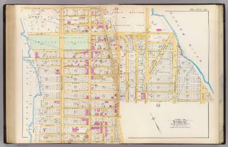
Pl. 43: ward 12.
1 : 2400 Bromley, George Washington; Bromley, Walter Scott
Part of Sections 7 & 8: Plate 161
from Atlas of the borough of Manhattan, city of New York.
Part of Section 7: Plate 157
from Atlas of the borough of Manhattan, city of New York.
Part of Sections 7 & 8: Plate 160
from Atlas of the borough of Manhattan, city of New York.
Manhattan, V. 11, Double Page Plate No. 255 [Map bounded by W. 155th St., Amsterdam Ave., W. 150th St., Hudson River]
From Atlas 42.61. Vol. 11-11 1/2, 1893.
Manhattan, V. 11, Double Page Plate No. 254 [Map bounded by W. 150th St., Amsterdam Ave., W. 145th St., Hudson River]
From Atlas 42.61. Vol. 11-11 1/2, 1893.
Part of Section 7: Plate 158
from Atlas of the borough of Manhattan, city of New York.
Plate 164: Bounded by W. 162nd Street, Amsterdam Avenue, W. 157th Street and Broadway.
from Atlas of the borough of Manhattan, city of New York.
Part of Section 8: Plate 165
from Atlas of the borough of Manhattan, city of New York.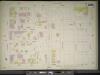
Manhattan, V. 11, Double Page Plate No. 256 [Map bounded by W. 155th St., 8th Ave., W. 150th St., Amsterdam Ave.]
From Atlas 42.61. Vol. 11-11 1/2, 1893.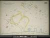
Manhattan, V. 11, Double Page Plate No. 258 [Map bounded by St. Nicholas Ave., Harlem River, W. 155th St.]
From Atlas 42.61. Vol. 11-11 1/2, 1893.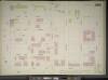
Manhattan, V. 11, Double Page Plate No. 253 [Map bounded by W. 150th St., 8th Ave., W. 145th St., Amsterdam Ave.]
From Atlas 42.61. Vol. 11-11 1/2, 1893.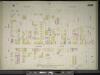
Manhattan, V. 11, Double Page Plate No. 259 [Map bounded by Boulevard, W. 162nd St., St. Nicholas Ave., W. 155th St.]
From Atlas 42.61. Vol. 11-11 1/2, 1893.
Part of Sections 7 & 8: Plate 162
from Atlas of the borough of Manhattan, city of New York.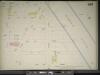
Manhattan, V. 11, Double Page Plate No. 257 [Map bounded by W. 155th St., Harlem River, W. 150th St., 8th Ave.]
From Atlas 42.61. Vol. 11-11 1/2, 1893.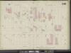
Manhattan, V. 11, Double Page Plate No. 246 [Map bounded by Boulevard, W. 145th St., Convent Ave., W. 138th St.]
From Atlas 42.61. Vol. 11-11 1/2, 1893.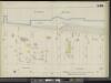
Manhattan, V. 11, Double Page Plate No. 245 [Map bounded by Hudson River, W. 145th St., Boulevard, W. 138th St.]
From Atlas 42.61. Vol. 11-11 1/2, 1893.
Part of Sections 6, 7 & 8: New York City.
from Atlas of the city of New York, Manhattan Island. From actual surveys and official plans / by George W. and Walter S. Bromley.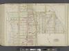
Manhattan, Double Page Plate No. 43 [Map bounded by W. 158thSt., Harlem River, W. 143rd St., Hudson River]
From Atlas of the city of New York, Manhattan Island. From actual surveys and official plans
Page 21: [Bounded by W. 156th Street, (Hamilton Heights) Ninth Avenue, W. 136th Street and North River.]
from Sackersdorf Farm Set.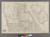
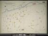
Part of Ward 12, New York City.
from Atlas of the city of New York : embracing all territory within its corporate limits from official records, private plans & actual surveys / by and under the supervision of E. Robinson & R.H. Pidgeon, civil engineers.
Fort Washington section.
From Manhattan
Part of Sections 6, 7 & 8: New York City.
from Atlas of the city of New York, borough of Manhattan. From actual surveys and official plans / by George W. and Walter S. Bromley.
30. Ward 12.
1 : 3600 G.W. Bromley & Co.; Geo. W. Bromley & E. Robinson
Sackersdorff Farm set.
from Maps of farms commonly called the Blue book, 1815 : drawn from the original on file in the street commissioner's office in the City of New York, together with lines of streets and avenues / laid out by John Randel, jr., 1819-20.
[Plate 45: Bounded by W. 170th Street, Edgecombe Avenue (Harlem River, High Bridge Park), W. 158th Street, Hudson River (N.Y.C. and H.R.R.R.).]
from Atlas of the city of New York, borough of Manhattan. From actual surveys and official plans / by George W. and Walter S. Bromley.
Page 23: [Bounded by W. 177th Street, Harlem River, w. 157th Street and Hudson River.]
from Maps of farms commonly called the Blue book, 1815 : drawn from the original on file in the street commissioner's office in the City of New York, together with lines of streets and avenues / laid out by John Randel, jr., 1819-20.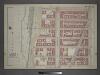
Plate 28: Part of Section 7.
from Atlas of the city of New York, borough of Manhattan / from actual surveys and official plans by George W. and Walter S. Bromley.
Part of Section 7: Plate 153
from Atlas of the borough of Manhattan, city of New York.