Maps of Hudson County
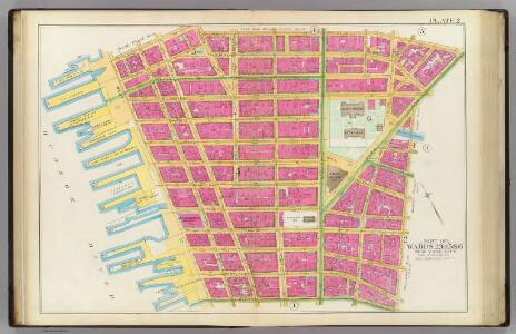
Pl. 2: wards 2-6.
1 : 1800 Bromley, George Washington; Bromley, Walter Scott
Manhattan, V. 4, Double Page Plate No. 5 [Map bounded by Worth St., New Bowery, Pearl St., Cold St., Beekman St., Barclay St., College Place, West Broadway]
From Vol. 4
1. Ward 1,3.
1 : 2400 G.W. Bromley & Co.; Geo. W. Bromley & E. Robinson
South of 14th Street Part of Wards 2, 3, 4, 5, and 6.
from Atlas of the City of New York. Vol. 4.
Part of Section 1 : Plate 5.
from Atlas of the borough of Manhattan, city of New York.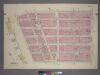
Plate 5, Part of Section 1: [Bounded by Reade Street, Broadway, Vesey Street and West Street.]
from Atlas of the city of New York, borough of Manhattan. From actual surveys and official plans / by George W. and Walter S. Bromley.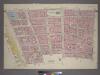
Plate 3, Part of Section 1: [Bounded by Vesey Street, Ann Street, William Street, Pine Street, Broadway, Thames Street, Greenwich Street, Carlisle Street and (Hudson River Piers) West Street.]
from Atlas of the city of New York, borough of Manhattan. From actual surveys and official plans / by George W. and Walter S. Bromley.
Part of Section 1 : Plate 3.
from Atlas of the borough of Manhattan, city of New York.
[Plate 9: Map bounded by Pearl Street, Chatham Street, Duane Street, Rose Street, Frankfort Street, City Hall Square, Murray Street, Church Street]
from Maps of the city of New York.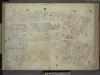
[Plate 9: Map bounded by Pearl Street, Chatham Street, Chambers Street, Rose Street, Frankfort Street, Murray Street, Church Street; Including Duane Street, City - Hall Place, Reade Street, Warren Street, Broadway, Elm Street, Centre Street
from Maps of the city of New-York.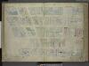
[Plate 7: Map bounded by Murray Street, Broadway, Dey Street, West Street; Including Robinson Street, Park Place, Barclay Street, Vesey Street, Fulton Street, Washington Street, Greenwich Street, College Place, Church Street]
from Maps of the city of New-York.
Part of Section 1 : Plate 6.
from Atlas of the borough of Manhattan, city of New York.
[Plate 7: Map bounded by Murray Street, Broadway, Dey Street, West Street]
from Maps of the city of New York.
Plate 7: Map bounded by Vesey Street, Broadway, Liberty Street, West Street.
from Maps of the city of New York / surveyed under directions of insurance companies of said city.
Plate 9: Map bounded by Greenwich Street, Barclay Street, College Place, West Broadway, Reade Street, Broadway, Vesey Street.
from Maps of the city of New York / surveyed under directions of insurance companies of said city.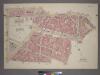
Plate 6, Part of Section 1: [Bounded by Reade Street, Duane Street, New Chambers Street, Roosevelt Street, Cherry Street, Franklin Square, Frankfort Street, Cliff Street, Beekman Street, Gold Street and Ann Street.]
from Atlas of the city of New York, borough of Manhattan. From actual surveys and official plans / by George W. and Walter S. Bromley.
Manhattan, V. 1, Plate No. West piers B [Map of west piers B.]
From Atlas 107. Vol. 1, 1894.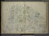
[Plate 6: Map bounded by Broadway, Park Row, Frankfort Street, Gold Street, Maiden Lane; Including Nassau Street, Theater Alley, Dutch Street, William Street, Platt Street, John Street, Fulton Street, Ann Street, Beekman Street, Spruce
from Maps of the city of New-York.
Plate 8: Map bounded by West Street, Reade Street, Hudson Street, College Place, Barclay Street, Greenwich Street, Vessey Street.
from Maps of the city of New York / surveyed under directions of insurance companies of said city.
[3rd Ward. Plate 5: Map bounded by College Place, West Broadway, Reade Street, Broadway, Park Place; Including Church Street, Murray Street, Warren Street, Chambers Street]
from Maps of the city of New York.
[3rd Ward. Plate 6: Map bounded by Fulton Street, Greenwich Street, Barclay Street, College Place, Park Place, Broadway; Including Vesey Street, Church Street]
from Maps of the city of New York.
[Plate 6: Map bounded by City Hall Square, Frankfort Street, Gold Street, Maiden Lane, Broadway, Park Row]
from Maps of the city of New York.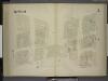
[3rd Ward. Plate 3: Map bounded by West Street, Robinson Street, College Place, Barclay Street, Greenwich Street, Courtland Street; Including Washington Street, Dey Street, Fulton Street, Vesey Street]
from Maps of the city of New York.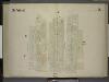
[3rd Ward. Plate 2: Map bounded by Greenwich Street, Fulton Street, Broadway, Liberty Street; Including Church St, Courtland Street, Dey Street]
from Maps of the city of New York.
Plate 28: Map bounded by Leonard Street, Centre Street, Chambers Street, Broadway, Reade Street, West Broadway.
from Maps of the city of New York / surveyed under directions of insurance companies of said city.
[Plate 6: Map bounded by Broadway, Park Row, Spruce Street, Gold Street, Liberty Street]
from Maps of the city of New York / surveyed under directions of insurance companies of said city.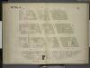
[3rd Ward. Plate 4: Map bounded by Robinson Street, West Street, Reade Street, Hudson Street, College Place; Including Murray Street, Warren Street, Chambers Street, Greenwich Street, Washington Street]
from Maps of the city of New York.
Manhattan, V. 1, Plate No. 7 [Map bounded by Murray St., Broadway, Dey St., College Pl.]
From Atlas 107. Vol. 1, 1894.
Manhattan, V. 1, Plate No. 6 [Map bounded by Broadway, Frankfort St., Gold St., Fulton St.]
From Atlas 107. Vol. 1, 1894.