Maps of Appalachian Mountains

Composite: United States of Nth. America.
1 : 1584000 Tardieu, P.F.
United States

States of America, drawn from the best authorities

An accurate map of the United States of America, with part of the surrounding provinces agreeable to the Treaty of Peace of 1783
1 : 1
Map of the United States and British Provinces of Upper and Lower Canada.
1 : 1838000 Shelton, W.
A New Map of the United States.
1 : 1520640 Carleton, Osgood
United States Of North America.
1 : 1550000 Arrowsmith, Aaron
A new map of the United States including part of Louisiana

United States of Nth. America.
1 : 1584000 Tardieu, P.F.
United States of America

United States of America.
1 : 1960000 Tanner, Henry S.
Map of the United States of America.
1 : 6500000 Winterbotham, W.
Etats Unis de l'Amérique
1 : 13000000 gravé par Tardieu corr. et augm. en 1803 [Paris] : [s.n.]
United States of America / drawn & engraved for Wardens Statistical account by W. & D. Lizars, Edinburgh
1 : 6000000 Annotatie: Uit: A statistical, political, and historical account of the United States of North America ... / D.B. Warden. - Edinburgh : Constable, 1819 William Lizars; Daniel Lizars [Edinburgh : A. Constable & Co.]
United States of Nth. America.
1 : 1584000 Tardieu, P.F.
CHARTE von den VEREINIGTEN STAATEN von NORD-AMERICA mit LUISIANA
Spojené státy americké-oblast východní
United States.
1 : 11800000 Bowen, Frances
United States of America.
1 : 5950000 Thomson, John
The United States of America, according to the Treaty of Peace of 1784 / Russell, del. et sculpt.
from Whole Russell,
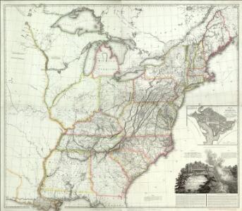
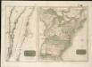
Map of the United States showing the land west of the Mississippi River still as Louisiana. Ohio is named as a state. Many Indian tribes and villages are named. A lead mine is located in today's northwestern Illinois. Florida is divided into the Spanish possessions of East and West Florida, Georgia extends to the Mississippi.
Watson's new rail-road and distance map of the United States and Canada.
1 : 2344320 Watson, Gaylord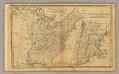
United States.
1 : 11700000 Adams, Daniel
United States.
1 : 10400000 Lucas, Fielding Jr.
Die Vereinigten Staaten von Nord-America
United States of America

Mitchell's map of the United States.
1 : 14752000 Mitchell, Samuel Augustus
United States of Nth. America = Carte des Etats-unis de l'Amérique septentrionale / copiée et gravée sur celle d'Arrowsmith; corrigée et considérablement augmentée d'après les renseignemens les plus authentiques par P.F. Tardieu, graveur, editeur-propriétaire, Place de l'Estrapade, No. 18. à Paris, an XL 1802; ecrit par J.J. Pachoux; Chles. Picquet, géographe-graveur ...
from Parts P.F. Tardieu; J. J. Pachoux; Charles Picquet,
United States Of North America.
1 : 1550000 Arrowsmith, Aaron
Die Vereinigten Staaten von Nordamerika
1 Karte : Kupferdruck ; 52 x 64 cm Lewis; Arrowsmith in der Schneider- und Weigelschen K.K. privilegirten Kunsthandlung
United States.
1 : 11400000 Arrowsmith, Aaron; Lewis, Samuel