Maps of Bronx County
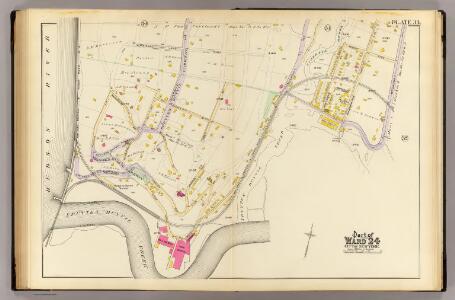
33, ward 24.
1 : 2400 Bromley, George Washington; Bromley, Walter Scott; G.W. Bromley & Co.
Plate 76, Part of Section 13, Borough of the Bronx. [Bounded by Spuyten Duyvil Road, W. 235th Street, Netherland Avenue, Kappock Street, W. Johnson Road and Broadway.]
from Atlas of borough of the Bronx, Sections 9 10 11 12 & 13 : from actual surveys and official plans / G.W. Bromley and Co.
Atlas of the borough of the Bronx, city of New York : based upon official plans and maps on file in the various city offices; supplemented by careful field measurements and personal observations, by and under the supervision of Hugo Ullitz.
from Atlas of the borough of the Bronx, city of New York : based upon official plans and maps on file in the various city offices; supplemented by careful field measurements and personal observations, by and under the supervision of Hugo Ullitz.
Manhattan, V. 12, Plate No. 28 [Map bounded by Johnson Ave., W. 232nd St., Broadway, W. 230th St.]
From Atlas 128. Vol. 12, 1900.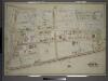
Atlas of the borough of the Bronx, city of New York : based upon official plans and maps on file in the various city offices; supplemented by careful field measurements and personal observations, by and under the supervision of Hugo Ullitz.
from Atlas of the borough of the Bronx, city of New York : based upon official plans and maps on file in the various city offices; supplemented by careful field measurements and personal observations, by and under the supervision of Hugo Ullitz.
Manhattan, V. 12, Plate No. 31 [Map bounded by Viaduct, Harlem River, Hudson River]
From Atlas 128. Vol. 12, 1900.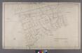
Map or Plan of Section 23. [Bounded by Spuyten Duvil Road, Palisade Avenue, W. 248th Street, Sycamore Avenue,W. 249th Street, Independence Avenue, W. 250th Street, Riverdale Avenue and W. 236th Street.]; Maps or plans and profiles, with field notes and explanatory remarks, showing the location, width, grades, and class of streets, roads, avenues, public squares and places, located and laid out by the Commissioner of Street Improvements of the 23rd and 24th wards of the city of New York: under authority of Chapter 545 of the laws of 1890.
from Maps or plans and profiles, with field notes and explanatory remarks, showing the location, width, grades, and class of streets, roads, avenues, public squares and places, located and laid out by the Commissioner of Street Improvements of the 23rd and 24th wards of the city of New York : under authority of Chapter 545 of the laws of 1890. New York (N.Y.). Topographical Bureau,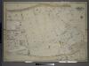
Atlas of the borough of the Bronx, city of New York : based upon official plans and maps on file in the various city offices; supplemented by careful field measurements and personal observations, by and under the supervision of Hugo Ullitz.
from Atlas of the borough of the Bronx, city of New York : based upon official plans and maps on file in the various city offices; supplemented by careful field measurements and personal observations, by and under the supervision of Hugo Ullitz.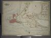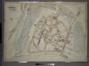
Manhattan, V. 12, Plate No. 34 [Map bounded by Oxford Ave., W. 236th St., Broadway, W. 232nd St.]
From Atlas 128. Vol. 12, 1900.
Manhattan, V. 12, Plate No. 29 [Map bounded by Harlem River, Spuyten Duyvil Creek]
From Atlas 128. Vol. 12, 1900.
Part of Section 8: Plate 191
from Atlas of the borough of Manhattan, city of New York.
Bronx, V. 13, Plate No. 4 [Map bounded by W. 227th St., Old Kingsbridge Rd., Kappock St., Arlington Ave.]
From Atlas 51.1. Vol. 13, 1914.
Manhattan, V. 12, Plate No. 33 [Map bounded by W. 236th St., Oxford Ave., W. 230th St., Spuyten Duyvil Parkway]
From Atlas 128. Vol. 12, 1900.
Manhattan, V. 12, Plate No. 82 [Map bounded by W. 230th St., Broadway, W. 227th St.]
From Atlas 129. Vol. 12, 1913.
Manhattan, V. 12, Plate No. 27 [Map bounded by Spuyten Duyvil Creek, Broadway, Harlem River]
From Atlas 128. Vol. 12, 1900.
Manhattan, V. 12, Plate No. 79 [Map bounded by W. 227th St., Jacobus Place., Harlem River, Teunissen Ave.]
From Atlas 129. Vol. 12, 1913.
Manhattan, V. 12, Plate No. 32 [Map bounded by Hudson River, W. 236th St., Fairfield Ave., W. 230th St.]
From Atlas 128. Vol. 12, 1900.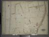
Atlas of the borough of the Bronx, city of New York : based upon official plans and maps on file in the various city offices; supplemented by careful field measurements and personal observations, by and under the supervision of Hugo Ullitz.
from Atlas of the borough of the Bronx, city of New York : based upon official plans and maps on file in the various city offices; supplemented by careful field measurements and personal observations, by and under the supervision of Hugo Ullitz.
Manhattan, V. 12, Plate No. 80 [Map bounded byW. 227th St., Broadway, W. 225th St., Van Corlears Place]
From Atlas 129. Vol. 12, 1913.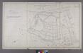
Section 22 of Final Maps and Profiles, of the 23rd & 24th Wards.
from Maps or plans and profiles, with field notes and explanatory remarks, showing the location, width, grades, and class of streets, roads, avenues, public squares and places, located and laid out by the Commissioner of Street Improvements of the 23rd and 24th wards of the city of New York : under authority of Chapter 545 of the laws of 1890.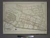
Plate 75, Part of Sections 8&13, Borough of the Bronx. [Bounded by Netherland Avenue, W. 235th Street, Spuyten Duyvil Road, W. 236th Street and Broadway.]
from Atlas of borough of the Bronx, Sections 9 10 11 12 & 13 : from actual surveys and official plans / G.W. Bromley and Co.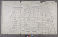
Map or Plan of Section 21. [Bounded by Riverdale Avenue, W. 238th Street, Spuyten Duvil Road, W. 240th Street, Van Cortlandt Avenue, Gun Hill Road, Sedgwick Avenue and Kingsbridge Road.]
from Maps or plans and profiles, with field notes and explanatory remarks, showing the location, width, grades, and class of streets, roads, avenues, public squares and places, located and laid out by the Commissioner of Street Improvements of the 23rd and 24th wards of the city of New York : under authority of Chapter 545 of the laws of 1890.
Sackersdorff Farm set.
from Maps of farms commonly called the Blue book, 1815 : drawn from the original on file in the street commissioner's office in the City of New York, together with lines of streets and avenues / laid out by John Randel, jr., 1819-20.
Sheet 20: [Bounded by 225th Street, (Spuyten Duyvel Creek Bulk Head Pier Line), 10th Avenue and 195th Street.]
from Plan of New York City, from the Battery to Spuyten Duyvil Creek. Showing every lot and building thereon; old farm lines, strreet numbers at the corners of blocks, railroads, steamboat landings, bulkhead and pier lines, etc. Based on the surveys made by Messrs. Randall & Blackwell, and on the special survey by J. F. Harrison.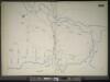
Manhattan, V. 11 1/2, Double Page Plate No. 255 [Map bounded by River St., Harlem River, W. 215th St.]
From Atlas 42.61. Vol. 11-11 1/2, 1893.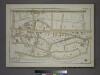
Plate 73, Part of Section 12, Borough of the Bronx. [Bounded by Broadway, W. 236th Street, Sedgwick Avenue, Kingsbridge Terrace, Albany Crescent, Heath Avenue and W. 230th Street.]
from Atlas of borough of the Bronx, Sections 9 10 11 12 & 13 : from actual surveys and official plans / G.W. Bromley and Co.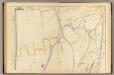
34 ward 24.
1 : 2400 Bromley, George Washington; Bromley, Walter Scott; G.W. Bromley & Co.