Maps of Bronx County
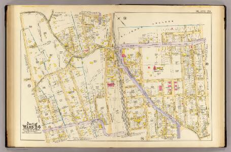
29, ward 24.
1 : 1800 Bromley, George Washington; Bromley, Walter Scott; G.W. Bromley & Co.
Planning Grid of the Office of the Topographical Bureau of Bronx.
from Topographical survey sheets of the borough of the Bronx easterly of the Bronx River.
Planning Grid of the Office of the Topographical Bureau of Bronx.
from Topographical survey sheets of the borough of the Bronx easterly of the Bronx River.
12, ward 23.
1 : 1800 Bromley, George Washington; Bromley, Walter Scott; G.W. Bromley & Co.
4A - N.Y. City (Aerial Set).
from Sectional aerial maps of the City of New York / [photographed and assembled under the direction of the chief engineer, July 1st, 1924].
Waverly, Town of Westchester.
from County atlas of Westchester, New York. Published by J.B. Beers & Co., assisted by S.W. Wilson and others.
Plate 26: Map 22 [Bounded by Harlem Rail Road, Union Avenue, Gamberleng Avenue and Road leading from Kingsbridge to West Farms.] - Mp No. 27: [Bounded by Railroad Ave. (Harlem Railroad), Quarry Road, Pine St., Central Ave., Locust Ave., and Morris St.]
from Certified copies of important maps appertaining to the 23rd and 24th wards, City of New York, filed in the Register's office at White Plains, County of Westchester, New York ...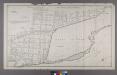
Map or Plan of Section 12. [Bounded by E. 176th Street, Southern Boulevard, E. 182nd Street and Bronx River.]
from Maps or plans and profiles, with field notes and explanatory remarks, showing the location, width, grades, and class of streets, roads, avenues, public squares and places, located and laid out by the Commissioner of Street Improvements of the 23rd and 24th wards of the city of New York : under authority of Chapter 545 of the laws of 1890.
Sheet 17: Grid #16000E - 20000E, #1000S - 3000N. [Includes Morris Park Race Track, (Westchester Square) and Westchester Heights.]
from Topographical survey sheets of the borough of the Bronx easterly of the Bronx River.
Sheet 18: Grid #16000E - 20000E, #1000S - 5000S. [Includes Morris Park Race Track, Morris Avenue, West Farms Road (Van Nest Station and Morris Park Station Rail Yards) and E. Tremont Avenue.]
from Topographical survey sheets of the borough of the Bronx easterly of the Bronx River.
Bronx, V. A, Plate No. 4 [Map bounded by Fowler Ave., Morris Park Ave., Unionport Rd., Neil Ave.]
From Vol. A
West Chester.
1 : 14400 Bromley, George Washington; Bromley, Walter Scott; G.W. Bromley & Co.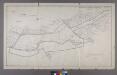
Map or Plan of Section 28. [Bounded by Southern Boulevard, E. 200th Street, Jerome Avenue, Gun Hill Road and Webster Avenue.]
from Maps or plans and profiles, with field notes and explanatory remarks, showing the location, width, grades, and class of streets, roads, avenues, public squares and places, located and laid out by the Commissioner of Street Improvements of the 23rd and 24th wards of the city of New York : under authority of Chapter 545 of the laws of 1890.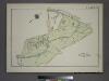
Plate 83, Part of Section 13, Borough of the Bronx. [Bounded by Webster Avenue, Bronx Boulevard, White Plains Road, E. 180th Street, Boston Road, E. 188th Street, Southern Boulevard and E. Fordham Road.]
from Atlas of borough of the Bronx, Sections 9 10 11 12 & 13 : from actual surveys and official plans / G.W. Bromley and Co.
Area District Map Section No. 4
from Area district map / City of New York, Board of Estimate and Apportionment.
Riderdale, Fieldston, Kingsbridge, North Riverdale, Spuyten Duyvil
From District 14
[Map of the city of New York and island of Manhattan as laid out by the commissioners appointed by the Legislature, April 3, 1807]
From Manhattan
Westchester, Pelham towns.
1 : 21120 Bien, Joseph Rudolf
Topographical atlas of the city of New York, including the annexed territory showing original water courses and made land. / prepared under the direction of Egbert L. Viele.
From Topographical atlas of the city of New York, including the annexed territory showing original water courses and made land
Hammods Atlas of New York City and the metropolitan district

Topographical atlas of the city of New York, including the annexed territory showing original water courses and made land. / prepared under the direction of Egbert L. Viele.
From Topographical atlas of the city of New York, including the annexed territory showing original water courses and made land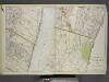
Portion of Bergen County, N.J.; Portion of Yonkers and 24th Ward.
from Atlas of the Hudson River Valley from New York city to Troy, including a section of about 8 miles in width. Published by Watson & co. Compiled from official records and careful surveys, under the supervision of F. W. Beers.
Hammods Atlas of New York City and the metropolitan district

Flushing
1 : 24000
Flushing
1 : 24000
Flushing
1 : 24000
Flushing
1 : 24000
Flushing
1 : 24000
Flushing
1 : 24000
Flushing
1 : 24000
Flushing
1 : 24000