Maps of Bronx County
27, ward 24.
1 : 1800 Bromley, George Washington; Bromley, Walter Scott; G.W. Bromley & Co.
Plate 62, Part of Section 11, Borough of the Bronx. [Bounded by E. Harlem River Terrace, W. fordham Road, Cedar Avenue, W. 182ndStreet, Sedgwick Avenue, W. 183rd Street, Aqueduct Avenue East, W. 184th Street, Grand Avenue and W. 188th Street.]
from Atlas of borough of the Bronx, Sections 9 10 11 12 & 13 : from actual surveys and official plans / G.W. Bromley and Co.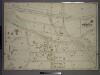
Double Page Plate No. 25, Part of Ward 24, Section 11. [Bounded by Exterior Street, Fordham Road, Aqueduct Avenue and E. 180th Street.]
from Atlas of the borough of the Bronx, city of New York : based upon official plans and maps on file in the various city offices; supplemented by careful field measurements and personal observations, by and under the supervision of Hugo Ullitz.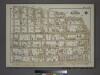
Plate 57, Part of Section 11, Borough of the Bronx. [Bounded by Aqueduct Avenue East, W. 184th Street, Grand Avenue, W. Fordham Road, E. Fordham Road, E. 188th Street, Grand Boulevard and E. 181st Street.]
from Atlas of borough of the Bronx, Sections 9 10 11 12 & 13 : from actual surveys and official plans / G.W. Bromley and Co.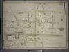
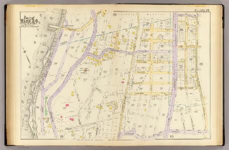
Double Page Plate No. 27, Part of Ward 24, Section 11. [Bounded by Aqueduct Avenue, E. 190th Street, Tee Taw Avenue, Kingsbridge Road, Aqueduct Avenue, E. 192nd Street, Jerome Avenue, E. 191st Street, Morris Avenue and E. 184th Street.]
from Atlas of the borough of the Bronx, city of New York : based upon official plans and maps on file in the various city offices; supplemented by careful field measurements and personal observations, by and under the supervision of Hugo Ullitz.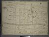
Double Page Plate No. 24, Part of Ward 24, Section 11. [Bounded by E. 180th Street, Aqueduct Avenue, E. 184th Street, Morris Avenue and Burnside Avneue.]
from Atlas of the borough of the Bronx, city of New York : based upon official plans and maps on file in the various city offices; supplemented by careful field measurements and personal observations, by and under the supervision of Hugo Ullitz.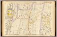
22, ward 24.
1 : 1800 Bromley, George Washington; Bromley, Walter Scott; G.W. Bromley & Co.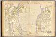
32, ward 24.
1 : 2400 Bromley, George Washington; Bromley, Walter Scott; G.W. Bromley & Co.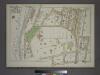
Plate 56, Part of Section 11, Borough of the Bronx. [Bounded by W. 183rd Street, Aqueduct Avenue East, W. 181st Street, Harrison Avenue, W. 179th Street, Loring Place, W. 180th Street.]
from Atlas of borough of the Bronx, Sections 9 10 11 12 & 13 : from actual surveys and official plans / G.W. Bromley and Co.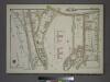
Plate 63, Part of Section 11, Borough of the Bronx. [Bounded by Bailey Avenue ... W. 188th Street, Grand Avenue, W. Kingsbridge Road, Heath Avenue and Knox Place.]
from Atlas of borough of the Bronx, Sections 9 10 11 12 & 13 : from actual surveys and official plans / G.W. Bromley and Co.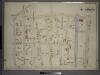
Double Page Plate No. 28, Part of Ward 24, Section 11. [Bounded by Fordham Road, Grand Boulevard and Concourse, E. 189th Street, Park Avenue, E. 183rd Street and Morris Avenue.]
from Atlas of the borough of the Bronx, city of New York : based upon official plans and maps on file in the various city offices; supplemented by careful field measurements and personal observations, by and under the supervision of Hugo Ullitz.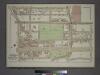
Plate 64, Part of Sections 11&12, Borough of the Bronx. [Bounded by Grand Avenue, W. Kingsbridge Road, Jerome Avenue, E. 196th Street, Valentine Avenue, E. 188th Street and W. Fordham Road.]
from Atlas of borough of the Bronx, Sections 9 10 11 12 & 13 : from actual surveys and official plans / G.W. Bromley and Co.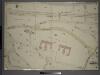
Double Page Plate No. 26, Part of Ward 24, Section 11. [Bounded by Harlem River, E. 192nd Street, Bailey Avenue, Heath Avenue, Emmerich Place, Kingsbridge Road, Tee Taw Avenue, E. 190th Street, Aqueduct Avenue and Fordham Road.]
from Atlas of the borough of the Bronx, city of New York : based upon official plans and maps on file in the various city offices; supplemented by careful field measurements and personal observations, by and under the supervision of Hugo Ullitz.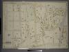
Double Page Plate No. 29, Part of Ward 24, Sections 11&12. [Bounded by Kingsbridge Road, E. 194th Street, Webster Avenue, Park Avenue, E. 189th Street, Grand Boulevard and Concourse, Fordham Road and Rome Avenue.]
from Atlas of the borough of the Bronx, city of New York : based upon official plans and maps on file in the various city offices; supplemented by careful field measurements and personal observations, by and under the supervision of Hugo Ullitz.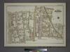
Plate 61, Part of Section 11, Borough of the Bronx. [Bounded by E. 188th Street, Webster Avenue, E. 189th Street, Washington Avenue, E. 187th Street, Lorillard Place, E. 184th Street, Webster Avenue, E. 183rd Street and Grand Boulevard.]
from Atlas of borough of the Bronx, Sections 9 10 11 12 & 13 : from actual surveys and official plans / G.W. Bromley and Co.
Manhattan, V. 12, Plate No. 24 [Map bounded by W. 216th St., Harlem River, W. 208th St., 10th Ave.]
From Atlas 128. Vol. 12, 1900.
Plate 185: Bounded by Nagle Avenue, Amsterdam Avenue, W. 208th Street, Harlem River and (Sherman's Creek) Academy Street.
from Atlas of the borough of Manhattan, city of New York.
Manhattan, V. 12, Plate No. 61 [Map bounded by 10th Ave., W. 210th St., Harlem River, W. 207th St.]
From Atlas 129. Vol. 12, 1913.
Double Page Plate No. 23, Part of Ward 24, Section 11. [Bounded by Morris Avenue, E. 183rd Street, Webster Avenue, E. 179th Street, Valentine Avenue E. 179th Street and Burnside Avneue.]
from Atlas of the borough of the Bronx, city of New York : based upon official plans and maps on file in the various city offices; supplemented by careful field measurements and personal observations, by and under the supervision of Hugo Ullitz.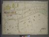
Double Page Plate No. 16, Part of Ward 24, Section 11. [Bounded by Exterior Street, Andrews Avenue and E. 177th Street.]
from Atlas of the borough of the Bronx, city of New York : based upon official plans and maps on file in the various city offices; supplemented by careful field measurements and personal observations, by and under the supervision of Hugo Ullitz.
Plate 188: Bounded by W. 214th Street, Columbus Avenue(Harlem River), W. 208th Street, Amsterdam Avenue, Ishan Street and Broadway.
from Atlas of the borough of Manhattan, city of New York.
Manhattan, V. 12, Plate No. 60 [Map bounded by 10th Ave., W. 207th St., Harlem River, W. 204th St.]
From Atlas 129. Vol. 12, 1913.
Manhattan, V. 12, Plate No. 62 [Map bounded by 10th Ave., W. 213th St., Harlem River, W. 210th St.]
From Atlas 129. Vol. 12, 1913.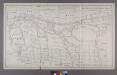
Map or Plan of Section 16. [Bounded by Burnside Avenue, Jerome Avenue, E. 184th Street, Walton Avenue, Morris Avenue and Kingsbridge Road.]
from Maps or plans and profiles, with field notes and explanatory remarks, showing the location, width, grades, and class of streets, roads, avenues, public squares and places, located and laid out by the Commissioner of Street Improvements of the 23rd and 24th wards of the city of New York : under authority of Chapter 545 of the laws of 1890.
Large folder - L1
from Atlas of New York and vicinity : from actual surveys / by and under the direction of F. W. Beers, assisted by A. B. Prindle & others
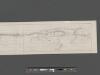
Bronx, Topographical Map Sheet 5; [Map bounded by Morkison St., Johnson Ave., Riverdale Ave., Ackerman St., Church St., Broadway, Macomb St., Albany Road, Bailas Ave., Heath Ave., Boston Ave., Sedgwick Ave.; Including Tee-Taw Ave., Aqueduct Ave., Hamp...
From Topographical map made from surveys by the commissioners of the Department of Public Parks of the City of New York of that part of Westchester County adjacent to the City and County of New York embraced by chapter 534 of laws of 1871 as amended b...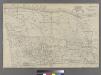
Plate 38: Bounded by Harlem River, Highbridge Road, Jerome Avenue, Primrose Street, Vanderbilt Avenue, ...
from Atlas of the city of New York : embracing all territory within its corporate limits from official records, private plans & actual surveys / by and under the supervision of E. Robinson & R.H. Pidgeon, civil engineers.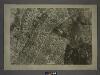
3B - N.Y. City (Aerial Set).
from Sectional aerial maps of the City of New York / [photographed and assembled under the direction of the chief engineer, July 1st, 1924].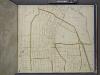
Bronx, Topographical Map Sheet 6; [Map bounded by Gambril St., Brook St., Low St., Lorilard Terrace, Bronx River, Southern Blvd., Kingsbridge, 3rd Ave., 182nd St.; Including Washington Ave., New York and Harlem Railroad, Webster Ave., Folin St., 4th ...
From Topographical map made from surveys by the commissioners of the Department of Public Parks of the City of New York of that part of Westchester County adjacent to the City and County of New York embraced by chapter 534 of laws of 1871 as amended b...