Maps of Bronx County

23, ward 24.
1 : 1800 Bromley, George Washington; Bromley, Walter Scott; G.W. Bromley & Co.
Double Page Plate No. 13, Part of Ward 24, Section 11. [Bounded by Grand Avenue, E. 177th Street, Grand Boulevard Concourse, Morris Avenue, Belmont Street, Walton Avenue, E. 174th Street and Featherbed Lane.]
from Atlas of the borough of the Bronx, city of New York : based upon official plans and maps on file in the various city offices; supplemented by careful field measurements and personal observations, by and under the supervision of Hugo Ullitz.
Plate 47, Part of Section 11, Borough of the Bronx. [Bounded by East Tremont Avenue, Third Avenue, E. 175th Street, Fulton Avenue, E. 174th Street, Park Avenue, E. 173rd Street and Monroe Avenue.]
from Atlas of borough of the Bronx, Sections 9 10 11 12 & 13 : from actual surveys and official plans / G.W. Bromley and Co.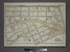
Plate 45, Part of Section 11, Borough of the Bronx. [Bounded by Jerome Avenue, Mt. Hope Place, Monroe Avenue, E. 173rd Street, Eastburn Avenue, Mt. Eden Avenue, Morris Avenue, Teller Avenue and E. 178th. Street.]
from Atlas of borough of the Bronx, Sections 9 10 11 12 & 13 : from actual surveys and official plans / G.W. Bromley and Co.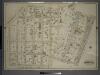
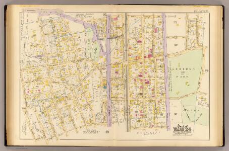
Double Page Plate No. 12, Part of Ward 24, Section 11. [Bounded by E. 176th Street, Park Avenue, E. 173rd Street, Topping Avenue, Belmont Street, Morris Avenue and Grand Boulevard Concourse.]
from Atlas of the borough of the Bronx, city of New York : based upon official plans and maps on file in the various city offices; supplemented by careful field measurements and personal observations, by and under the supervision of Hugo Ullitz.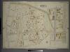
Double Page Plate No. 18, Part of Ward 24, Section 11. [Bounded by Burnside Avenue, E. 179th Street, Park Avenue, E. 176th Street, Carter Avenue, E. 176th Street and Morris Avenue.]
from Atlas of the borough of the Bronx, city of New York : based upon official plans and maps on file in the various city offices; supplemented by careful field measurements and personal observations, by and under the supervision of Hugo Ullitz.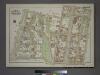
Plate 53, Part of Section 11, Borough of the Bronx. [Bounded by E. 180th Street, Webster Avenue, E. 181st Street, Bathgate Avenue, E. Tremont Avenue and Grand Boulevard.]
from Atlas of borough of the Bronx, Sections 9 10 11 12 & 13 : from actual surveys and official plans / G.W. Bromley and Co.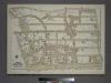
Plate 54, Part of Section 11, Borough of the Bronx. [Bounded by Harrison Avenue, W. 181st Street, E. 181st Street, Grand Boulevard, Mt. Hope Place, Jerome Avenue, W. 177th Street and W. Tremont Avenue.]
from Atlas of borough of the Bronx, Sections 9 10 11 12 & 13 : from actual surveys and official plans / G.W. Bromley and Co.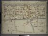
Double Page Plate No. 11, Part of Ward 24, Section 11. [Bounded by Park Avenue, E. 179th Street, Lafontaine Avenue, E. 177th Street, Tremont Avenue and (Crotona Park) Third Avenue.]
from Atlas of the borough of the Bronx, city of New York : based upon official plans and maps on file in the various city offices; supplemented by careful field measurements and personal observations, by and under the supervision of Hugo Ullitz.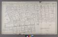
Map or Plan of Section 14. [Bounded by E. 173rd Street, Washington Avenue, Wendover Avenue, Clay I Avenue, Belmont Street, Jerome Avenue, E. 184th Street, Webster Avenue, E. 179th Street and Third Avenue.]
from Maps or plans and profiles, with field notes and explanatory remarks, showing the location, width, grades, and class of streets, roads, avenues, public squares and places, located and laid out by the Commissioner of Street Improvements of the 23rd and 24th wards of the city of New York : under authority of Chapter 545 of the laws of 1890.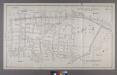
Map or Plan of Section 13. [Bounded by E. 179th Street, Lafantaine Avenue, E. 178th Street, Third Avenue, E. 179th Street, Webster Avenue, Southern Boulevard and Crotona Avenue.]; Maps or plans and profiles, with field notes and explanatory remarks, showing the location, width, grades, and class of streets, roads, avenues, public squares and places, located and laid out by the Commissioner of Street Improvements of the 23rd and 24th wards of the city of New York: under authority of Chapter 545 of the laws of 1890.
from Maps or plans and profiles, with field notes and explanatory remarks, showing the location, width, grades, and class of streets, roads, avenues, public squares and places, located and laid out by the Commissioner of Street Improvements of the 23rd and 24th wards of the city of New York : under authority of Chapter 545 of the laws of 1890. New York (N.Y.). Topographical Bureau,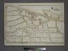
Plate 44, Part of Section 11, Borough of the Bronx. [Bounded by University Avenue, W. 176th Street, Andrews Avenue, West Tremont Avenue, W. 177th Street, Jerome Avenue and W. 179th Street.]
from Atlas of borough of the Bronx, Sections 9 10 11 12 & 13 : from actual surveys and official plans / G.W. Bromley and Co.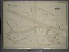
Double Page Plate No. 14, Part of Ward 24, Section 11. [Bounded by Montgomery Avenue, E. 177th Street, Aqueduct Avenue, Grand Avenue, Harrison Avenue and Featherbed Lane.]
from Atlas of the borough of the Bronx, city of New York : based upon official plans and maps on file in the various city offices; supplemented by careful field measurements and personal observations, by and under the supervision of Hugo Ullitz.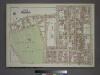
Plate 46, Part of Section 11, Borough of the Bronx. [Bounded by E. 173rd Street, Park Avenue, E. 174th Street, Fulton Avenue, E. 174th Street, Clay Avenue, Mt. Eden Avenue and Eastburn Avenue.]
from Atlas of borough of the Bronx, Sections 9 10 11 12 & 13 : from actual surveys and official plans / G.W. Bromley and Co.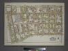
Plate 52, Part of Section 11, Borough of the Bronx. [Bounded by E. 181st Street, Mapes Avenue, E. Tremont Avenue, and Bathgate Avenue.]
from Atlas of borough of the Bronx, Sections 9 10 11 12 & 13 : from actual surveys and official plans / G.W. Bromley and Co.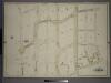
Double Page Plate No. 17, Part of Ward 24, Section 11. [Bounded by E. 180th Street, Morris Avenue, E. 177th Street and Andrews Place.]
from Atlas of the borough of the Bronx, city of New York : based upon official plans and maps on file in the various city offices; supplemented by careful field measurements and personal observations, by and under the supervision of Hugo Ullitz.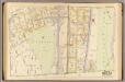
20, ward 24.
1 : 1800 Bromley, George Washington; Bromley, Walter Scott; G.W. Bromley & Co.
Double Page Plate No. 23, Part of Ward 24, Section 11. [Bounded by Morris Avenue, E. 183rd Street, Webster Avenue, E. 179th Street, Valentine Avenue E. 179th Street and Burnside Avneue.]
from Atlas of the borough of the Bronx, city of New York : based upon official plans and maps on file in the various city offices; supplemented by careful field measurements and personal observations, by and under the supervision of Hugo Ullitz.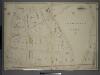
Double Page Plate No. 2, Part of Ward 24, Section 11. [Bounded by Belmont Street, Clay Avenue, E. 170th Street and Walton Avenue.]
from Atlas of the borough of the Bronx, city of New York : based upon official plans and maps on file in the various city offices; supplemented by careful field measurements and personal observations, by and under the supervision of Hugo Ullitz.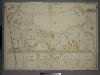
Double Page Plate No. 2, Part of Ward 24, Sections 9&11. [Bounded by Nelson Avenue, Featherbed Lane, E. 174th Street, Walton Avenue, Elliot Place, Jemorem Avenue, E. 170th Street and Boscobel Avenue.]
from Atlas of the borough of the Bronx, city of New York : based upon official plans and maps on file in the various city offices; supplemented by careful field measurements and personal observations, by and under the supervision of Hugo Ullitz.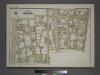
Plate 58, Part of Section 11, Borough of the Bronx. [Bounded by E. 183rd Street, Webster Avenue, E. 184th Street, Third Avenue, E. 181st Street, Webster Avenue, E. 180th Street and Grand Boulevard.]
from Atlas of borough of the Bronx, Sections 9 10 11 12 & 13 : from actual surveys and official plans / G.W. Bromley and Co.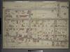
Double Page Plate No. 4, Part of Ward 24, Section 11. [Bounded by Webster Avenue, 173rd Street, Park Avenue, E. 174th Street, Fulton Avenue and St. Paul Place.]
from Atlas of the borough of the Bronx, city of New York : based upon official plans and maps on file in the various city offices; supplemented by careful field measurements and personal observations, by and under the supervision of Hugo Ullitz.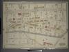
Double Page Plate No. 19, Part of Ward 24, Section 11. [Bounded by Webster Avenue, E. 184th Street, Belmont Place, Quarry Road, Lafontaine Avenue and E. 179th Street.]
from Atlas of the borough of the Bronx, city of New York : based upon official plans and maps on file in the various city offices; supplemented by careful field measurements and personal observations, by and under the supervision of Hugo Ullitz.
Plate 16: Tremont, Town of West Farms, Westchester Co. N.Y.
from County atlas of Westchester, New York. Published by J.B. Beers & Co., assisted by S.W. Wilson and others.
Plate 9: Tremont : Town of West Farms.
from Atlas of New York and vicinity : from actual surveys / by and under the direction of F. W. Beers, assisted by A. B. Prindle & others
Bronx, Topographical Map Sheet 8; [Map bounded by Buchanan PL., 4th St., Webster Ave., Grove St., 3rd Ave., Quarry Road, Boston Road; Including 170th St., Elliot St., Findlay Ave., Mott Ave., Jerome Ave., 1st Ave., Macombs Dam Road]
From Topographical map made from surveys by the commissioners of the Department of Public Parks of the City of New York of that part of Westchester County adjacent to the City and County of New York embraced by chapter 534 of laws of 1871 as amended b...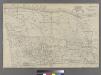
Plate 38: Bounded by Harlem River, Highbridge Road, Jerome Avenue, Primrose Street, Vanderbilt Avenue, ...
from Atlas of the city of New York : embracing all territory within its corporate limits from official records, private plans & actual surveys / by and under the supervision of E. Robinson & R.H. Pidgeon, civil engineers.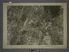
3D - N.Y. City (Aerial Set).
from Sectional aerial maps of the City of New York / [photographed and assembled under the direction of the chief engineer, July 1st, 1924].
Use District Map Section No. 3; Use district map / City of New York, Board of Estimate and Apportionment.
from Use district map / City of New York, Board of Estimate and Apportionment. New York (N.Y.). Board of Estimate and Apportionment,
Height District Map Section No. 3; Height district map / City of New York, Board of Estimate and Apportionment.
from Height district map / City of New York, Board of Estimate and Apportionment. New York (N.Y.). Board of Estimate and Apportionment,