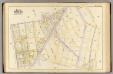
Maps of Bronx County
14, ward 23.
1 : 1800 Bromley, George Washington; Bromley, Walter Scott; G.W. Bromley & Co.
Bronx, V. 14, Plate No. 55 [Map bounded by E. 163rd St., Dawson St., E. 156th St., Prospect Ave.]
From Atlas 52. Vol. 14, 1901.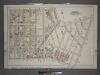
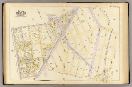
Plate 14: Part of Section 10, Borough of the Bronx. [Bounded by E. 165th Street, Rogers Place, Dongan Street, Southern Boulevard, E. 156th Street and Cauldwell Avenue.]
from Atlas and owners names, borough of the Bronx, sections 9 & 10 : from actual surveys and official plans / by George W. and Walter S. Bromley.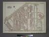
Plate 27, Part of Section 10, Borough of the Bronx. [Bounded by Westchester Avenue, E. 163rd Street, Hunts Point Avenue, Barretto Street, Lafayette Avenue, Barry Street, Longwood Avenue, and Hewitts Place.]
from Atlas of borough of the Bronx, Sections 9 10 11 12 & 13 : from actual surveys and official plans / G.W. Bromley and Co.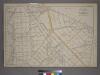
Plate 19: [Bounded by Bungay St., Southern Blvd., Prospect Ave., Dongan St., Fox St., Barretto St., Wetmore Ave.,Tiffany St., Craven St., Bacon St., Winslow St., Conover Ave. and Edgewater Road.]
from Atlas of the city of New York : from official records, private plans & actual surveys / compiled under the supervision of E. Robinson & R. H. Pidgeon.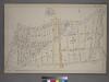
Plate 16: [Bounded by E. 167th St., Westchester Ave., Longfellow St., Dongan Ave., Stebbins Ave. and Prospect Ave.]
from Atlas of the city of New York : from official records, private plans & actual surveys / compiled under the supervision of E. Robinson & R. H. Pidgeon.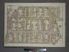
Plate 22, Part of Section 10, Borough of the Bronx. [Bounded by E. 166th Street, Hall Place, E. 165th Street, Westchester Avenue, E. 161st Street and Third Avenue.]
from Atlas of borough of the Bronx, Sections 9 10 11 12 & 13 : from actual surveys and official plans / G.W. Bromley and Co.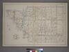
Part of the 23rd Ward, New York City.
from Atlas of the city of New York : from official records, private plans & actual surveys / compiled under the supervision of E. Robinson & R. H. Pidgeon.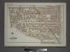
Plate 28, Part of Section 10, Borough of the Bronx. [Bounded by Southern Boulevard, E. 163rd Street, Stebbins Avenue, E. 165th Street, Hall Place, and Home Street.]
from Atlas of borough of the Bronx, Sections 9 10 11 12 & 13 : from actual surveys and official plans / G.W. Bromley and Co.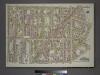
Plate 23, Part of Section 10, Borough of the Bronx. [Bounded by E. 161st Street, Hewitt's Place, Longwood Avenue, Dawson Street, Leggett Avenue, Kelly Street, E. 152nd Street, and St. Anns Avenue.]
from Atlas of borough of the Bronx, Sections 9 10 11 12 & 13 : from actual surveys and official plans / G.W. Bromley and Co.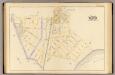
16, ward 23.
1 : 2400 Bromley, George Washington; Bromley, Walter Scott; G.W. Bromley & Co.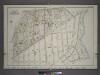
Plate 15: Part of Section 10, Borough of the Bronx. [Bounded by Home Street, Westchester Avenue, Edgewater Road, Garrison Avenue, Faile Street, Whitlock Avenue, Dongan Street, Rogers Place, E. 165th Street, Hall Place and Intervale Avenue.]
from Atlas and owners names, borough of the Bronx, sections 9 & 10 : from actual surveys and official plans / by George W. and Walter S. Bromley.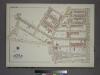
Plate 26, Part of Section 10, Borough of the Bronx. [Bounded by Southern Boulevard, Avenue St. John, Kelly Street, Leggett Avenue, Dawson Street, Longwood Avenue, Garrison Avenue, Leggett Avenue, Whitlock Avenue and E. 149th Street.]
from Atlas of borough of the Bronx, Sections 9 10 11 12 & 13 : from actual surveys and official plans / G.W. Bromley and Co.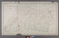
Section 3 of Final Maps and Profiles, of the 23rd & 24th Wards.
from Maps or plans and profiles, with field notes and explanatory remarks, showing the location, width, grades, and class of streets, roads, avenues, public squares and places, located and laid out by the Commissioner of Street Improvements of the 23rd and 24th wards of the city of New York : under authority of Chapter 545 of the laws of 1890.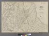
Plate 36: Bounded by Horton Street, Third Boston Road, Briston Street, ....Bronx River, Dickey Street, Hunt's Point Road, Southern Boulevard, ...... Clifton Street and Third Avenue.
from Atlas of the city of New York : embracing all territory within its corporate limits from official records, private plans & actual surveys / by and under the supervision of E. Robinson & R.H. Pidgeon, civil engineers.
Waverly, Town of Westchester.
from County atlas of Westchester, New York. Published by J.B. Beers & Co., assisted by S.W. Wilson and others.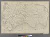
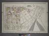
Part of Ward 23, New York City.
from Atlas of the city of New York : embracing all territory within its corporate limits from official records, private plans & actual surveys / by and under the supervision of E. Robinson & R.H. Pidgeon, civil engineers.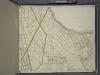
Bronx, Topographical Map Sheet 12; [Map bounded by Foote Ave., Maple Coster St., Maxwell Conover St., Wenman Ave., Randall Ave.; Including Wetmore Ave., Whitlock Ave., Southern Blvd., Fox St., Prospect Ave., Union Ave., Beck St.]
From Topographical map made from surveys by the commissioners of the Department of Public Parks of the City of New York of that part of Westchester County adjacent to the City and County of New York embraced by chapter 534 of laws of 1871 as amended b...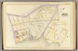
3, ward 23.
1 : 1800 Bromley, George Washington; Bromley, Walter Scott; G.W. Bromley & Co.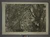
6B - N.Y. City (Aerial Set).
from Sectional aerial maps of the City of New York / [photographed and assembled under the direction of the chief engineer, July 1st, 1924].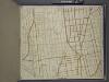
Bronx, Topographical Map Sheet 11; [Map bounded by Union Ave., Tinton Ave., Westchester Ave., Eacle Ave., St. Ann's Ave., Rae St., Cerman PL., Brook Ave., Bercen Ave., 3rd Ave.; Including 153rd St., Rail Road Ave. East, Sheridan Ave., Mott Ave., Walto...
From Topographical map made from surveys by the commissioners of the Department of Public Parks of the City of New York of that part of Westchester County adjacent to the City and County of New York embraced by chapter 534 of laws of 1871 as amended b...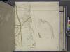
Bronx, Topographical Map Sheet 9; [Map bounded by Southern Blvd., Kingsbridge Road, Bronx River, Home St.; Including Westchester Ave., Intervale Ave., Stebbins Ave., Marion Ave.]
From Topographical map made from surveys by the commissioners of the Department of Public Parks of the City of New York of that part of Westchester County adjacent to the City and County of New York embraced by chapter 534 of laws of 1871 as amended b...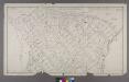
Section 4 of Final Maps and Profiles, of the 23rd & 24th Wards.
from Maps or plans and profiles, with field notes and explanatory remarks, showing the location, width, grades, and class of streets, roads, avenues, public squares and places, located and laid out by the Commissioner of Street Improvements of the 23rd and 24th wards of the city of New York : under authority of Chapter 545 of the laws of 1890.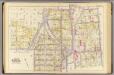
8, ward 23.
1 : 1800 Bromley, George Washington; Bromley, Walter Scott; G.W. Bromley & Co.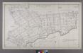
Map or Plan of Section 11. [Bounded by Mohawk Avenue, Southern Boulevard, E. 165th Street, Prospect Avenue, E. 169th Street, Intervale Avenue, Freeman Street, Southern Boulevard, E. 176th Street and Bronx River.]
from Maps or plans and profiles, with field notes and explanatory remarks, showing the location, width, grades, and class of streets, roads, avenues, public squares and places, located and laid out by the Commissioner of Street Improvements of the 23rd and 24th wards of the city of New York : under authority of Chapter 545 of the laws of 1890.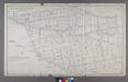
Map or Plan of Section 6. [Bounded by Courtlandt Avenue, New York and Harlem Railroad, E. 168th Street, Prospect Avenue and Westchester Avenue.]
from Maps or plans and profiles, with field notes and explanatory remarks, showing the location, width, grades, and class of streets, roads, avenues, public squares and places, located and laid out by the Commissioner of Street Improvements of the 23rd and 24th wards of the city of New York : under authority of Chapter 545 of the laws of 1890.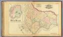
36. Ward 23.
1 : 7200 G.W. Bromley & Co.; Geo. W. Bromley & E. Robinson
Plate 6: Map No. 141 [Bounded by James Street, (Wm. Morris Farm), Rail Road Avenue, Prospect Street, Juliet Street, Gerard Street, Henry Street and River Avenue.]- Map No. 286 {Bounded by James WElls Land, Mill Brook, Henry Street and Morse Avenue or Old
from Certified copies of important maps appertaining to the 23rd and 24th wards, City of New York, filed in the Register's office at White Plains, County of Westchester, New York ...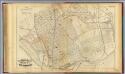
34. Ward 23.
1 : 4800 G.W. Bromley & Co.; Geo. W. Bromley & E. Robinson