Maps of Maine
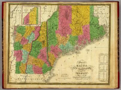
Map of Maine, New Hampshire,and Vermont.
1 : 1020000 Mitchell, Samuel Augustus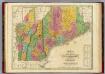
Map of Maine New Hampshire And Vermont.
1 : 990000 Finley, Anthony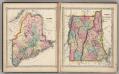
Maine. Vermont and New Hampshire.
1 : 1650000 Schonberg & Co.
Quebec, New Brunswick, Maine, Vermont, New Hampshire.
1 : 1584000 Smith, J. Calvin
A map of the New England states : Maine, New Hampshire, Vermont, Massachusetts, Rhode Island & Connecticut, with the adjacent parts of New York & lower Canada
1 : 506880 Hale, Nathan, 1784-1863 Nathan Hale
Maine, New Hampshire, Vermont, Massachusetts, Connecticut & Rhode Island.
1 : 1140480 Tanner, Henry S.
Map Of The States Of Maine, New Hampshire, Vermont, Massachusetts, Connecticut & Rhode Island.
1 : 1140480 Tanner, Henry S.
Maine, New Hampshire, Vermont, Massachusetts, Connecticut & Rhode Island.
1 : 1140480 Tanner, Henry S.
Maine, New Hampshire, Vermont, Massachusetts, Connecticut & Rhode Island.
1 : 1140480 Tanner, Henry S.
Maine, New Hampshire, Vermont, Massachusetts, Connecticut & Rhode Island.
1 : 1140480 Tanner, Henry S.
Map of the New England or Eastern States.
1 : 3000000 Mitchell, Samuel Augustus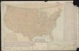
Parcel post map of the United States
1 : 7800000 L.L. Poates Engr'g Co. L.L. Poates Engr'g Co.
Map of New England with adjacent portions of New York & Canada
1 : 1537500 Walling, Henry Francis Walling, Henry Francis
Maine and New Hampshire.
1 : 1811877 Fisher, Richard Swainson
Map of New England

New England.
1 : 2100000 Mitchell, Samuel Augustus
New England.
1 : 1330560 Cram Atlas Company
Map of Maine, New Hampshire, Vermont, Massachusetts, Rhode Island, and Connecticut.
1 : 633600 Burr, David H., 1803-1875
New England States.
1 : 2250000 Huntington, Hezekiah, 1795-1865
Map of New England, with adjacent portions of New York & Canada

States of Maine, New Hampshire, Vermont, Massachusetts, Connecticut, & Rhode Island.
1 : 1110000 Tanner, Henry S.
New England And Lower Canada.
1 : 1520640 Johnson, A.J.
G. Woolworth Colton's railroad, township & distance map of New England with adjacent portions of New York, Canada & New Brunswick
1 : 900000 Colton, G. Woolworth Colton, G. Woolworth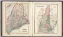
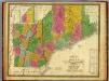
Maine. New Hampshire.
1 : 1250000 Gray, Ormando Willis
[Map of New England, 31st]

The New England states and part of Canada

Map of the district of Maine : from the latest and best authorities
1 : 506880 Greenleaf, Moses, 1777-1834 Cummings & Hilliard
New England.
1 : 1550000 Walling, H. F.
Maine.
1 : 1550000 Tanner, Henry S.