Maps of Ellesmere Island

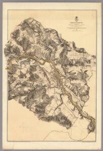
Fredericksburg.
1 : 21120 Weyss, John E.
Chart exhibiting the discoveries of the second American-Grinnell-Expedition in search of Sir John Franklin : unrevised from the original material and projected on the spot
Kane, Elisha Kent, 1820-1857 Lith of J. Bien
Baffin Bay journey.
1 : 3200000 Hayes, Isaac Israel
North America polar regions : Baffin Bay to Lincoln Sea showing the most recent discoveries including those of U.S.S. Polaris Expedition in 1871-2, under Captain C.F. Hall, British Arctic Expedition in 1875-6, under Captain G.S. Nares, R.N., The Lady Franklin Bay Expedition in 1881-4, under Lieutenant A.W. Greely, U.S.A
1 : 1500000 United States. Hydrographic Office Hydrographic Office, Navy Dept.
Septemtrionaliora Americæ à Groenlandia, per freta Davidis et Hudson, ad Terram Novam
1 Karte : Kupferdruck ; 48 x 55 cm Renard Louis Renard
Vorstellung des Meers in Norden von Asien und America, nebst der Berechnung von dessen Grösse und Ausdehnung
Asie severní
Carte marine, de la B. de Baffin, et une partie d'Hudson, d'Island et Groenland
1 Karte : Kupferdruck ; 42 x 48 cm Königliche Akademie der Wissenschaften
Gletscherkarte
Atlas der Geologie Zittel, K.v. ; Berghaus, Hermann Justus Perthes
A General Chart ... Davis Straits & Baffin Islands Bay.
1 : 19000000 Melish, John
Pas-caerte van Groenlandt, Yslandt, Straet Davids en Ian Mayen Eylant
1 Karte : Kupferdruck ; 43 x 52 cm Doncker bÿ Hendrick Doncker boekverkoper en graadbooghmaker inde Nieubrughsteegh
An exact map of North and South Carolina & Georgia : with east and west Florida from the latest discoveries / J. Lodge, sculp.
from Parts
Arctic Regions.
1 : 19000000 Thomson, John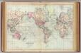
World, Mercator's projection.
1 : 68000000 Asher & Adams
185-186. North Canada, Greenland. The World Atlas.
1 : 7500000 USSR (Union of Soviet Socialist Republics).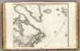
Amerique Septentrionale 2.
1 : 7500000 Brue, Adrien Hubert, 1786-1832
Canada - East. Pergamon World Atlas.
1 : 10000000 Polish Army Topography Service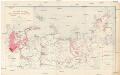
Sovetskaja Arktika
1 : 6000000 Arktida Atlasov, I.P. Glavsevmorput'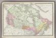
British America.
1 : 14000000 Rand McNally and Company
Di-gyiu Du, Ng Da-tsiu Di-du[地舆图、五大洲地图]
Di-gyiu Du, Ng Da-tsiu Di-du[地舆图、五大洲地图] 1853年,Martin, W. A. P. (William Alexander Parsons) 美国长老会传教士丁韪良用罗马拼音标注宁波方言编写的世界地理著作,对地球和各大洲进行介绍。内有东西半球图、亚洲图、欧洲图、非洲图、北美洲图、南美洲图、地中海附近图、清内地十八省图、浙江省图、宁波附近图等。 10图,墨刻本,罗马拼音标注宁波方言,图幅不一,约39 x 49.5 cm Harvard-Yenching | Rare Book | TA 2370 92,Hollis Number:008156153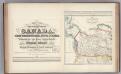
Facsimile: Canada and United States (portion).
1 : 15600000 Bouchette, Joseph
British possessions in North America / drawn and engraved by J. & C. Walker.
from Parts J. & C. Walker,
Canada.
1 : 15840000 Letts, Son & Co.
Brit. Nord-America.
1 : 15600000 Flemming, Carl
Carte du Canada ou de la Nouvelle France : et des découvertes qui y ont été faites / dressée sur plusieurs observations et sur un grand nombre de relations imprimées ou manuscrites par Guillaume del'Isle de l'Académie royale des sciences et premier géogr
from John H. Levine Collection
Arctic Regions.
Fullarton, A. & Co.
Britisches Nord Amerika.
1 : 23000000 Lange, Henry, 1821-1893.
British North America.
1 : 15500000 Society for the Diffusion of Useful Knowledge (Great Britain)
L'Empire russe en Europe et en Asie
1 Karte : mehrfarbig ; 31 x 51 cm de l'imprimerie de Pierre Didot l'aîné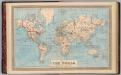
Map of the world on Mercator's projection.
1 : 70000000 H.W. Burgett and Company