Maps of Boston
17. Wards 9, 12.
1 : 1200 Bromley, George Washington; Bromley, Walter Scott
18. Wards 12, 17-18.
1 : 1200 Bromley, George Washington; Bromley, Walter Scott
16. Ward 9.
1 : 1200 Bromley, George Washington; Bromley, Walter Scott
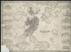
To His Excellency William Burnet, Esqr. This Plan of Boston in New England...

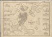
Plan of Boston
Mitchell, Samuel Augustus Jr.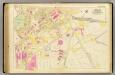
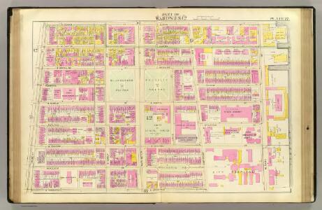
43. Ward 17.
1 : 1200 Bromley, George Washington; Bromley, Walter Scott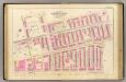
11. Wards 10, 12, 18.
1 : 1200 Bromley, George Washington; Bromley, Walter Scott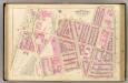
12. Wards 10-12.
1 : 1200 Bromley, George Washington; Bromley, Walter Scott
New map of Boston, comprising the whole city with the new boundaries of the wards
Forbes Lithograph Manufacturing Company
New map of Boston, comprising the whole city, with the new boundaries of the wards
Boynton, George W.
New map of Boston, comprising the whole city, with the new boundaries of the wards
Boynton, George W.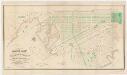
Plan of lands on the Back Bay : belonging to the Boston Water Power Co., the Commonwealth, and other parties, showing the system of streets & grades as laid out and recommended by the Back Bay Commissioners
1 : 3600 Boston (Mass.). Back Bay Commissioners A. Meisel, lith.
Plan of Boston comprising a part of Charlestown and Cambridge
1 : 7310 Smith, George Girdler, 1795-1878 George G. Smith
Plan of Boston comprising a part of Charlestown and Cambridgeport
1 : 6090 Fuller, Stephen P Annin & Smith ; J.V.N. Throop
Plan of Boston comprising a part of Charlestown and Cambridge
1 : 7380 Smith, George Girdler, 1795-1878 George G. Smith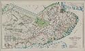
Plan of Boston proper : showing changes in street and wharf lines, 1795 to 1895
1 : 4800 Perkins, Charles Carroll H.H. Lloyd
Boston: Bird's-eye view from the North
Bachmann, John L. Prang & Co.
Plan of Boston comprising a part of Charlestown and Cambridge
1 : 7310 Smith, George Girdler, 1795-1878 George G. Smith
A plan of those parts of Boston, and the towns in its vicinity, with the waters and flats adjacent, which are immediately or remotely connected with the contemplated design of erecting perpetual tide-mills
Plan of Boston with parts of the adjacent towns
Plan of Boston with parts of the adjacent towns

Boston, pt. of Charlestown, Cambridge.
1 : 7000 Smith, George G.
Boston and Adjacent Cities.
1 : 20000 Colton, G.W.
A New and Complete Map of the city of Boston, with part of Charlestown, Cambridge, & Roxbury

Boston and Adjacent Cities.
1 : 19500 Colton, G.W.
Boston and Adjacent Cities.
1 : 20000 Colton, G.W.
New map of Boston : with squares and numbers after the Baedeker plan
1 : 8350 Boston Map Co.
Map of the town of Roxbury
Hales, John Groves Boston (Mass.).
Boston and Adjacent Cities.
1 : 19500 Colton, G.W.