Maps of Czech Republic

SE pt. of Germany.
1 : 2650000 Bowen, Emanuel
Bez titulu: Rakouské dějiny

Mapa vsi Dědová s přilehlým vrchnostenských dvorem a lesem
1 : 3625
Die Kaiserl. Oesterreichischen Provinzen in Deutschland nebst dem Fürstenthume Liechtenstein
Österreich
Germany. Deutschland IV. Austrian Dominions I.
1 : 1760000 Society for the Diffusion of Useful Knowledge (Great Britain)
SO Deutschland, Oesterreich. Lande.
1 : 5500000 Brudin, J. L.; Stieler, Adolf
Süd-Östliches Deutschland, enthält die Oesterreichischen Lande
Schul-Atlas über alle Theile der Erde nach dem neuesten Zustande, und über das Weltgebäude Stieler, Adolf bei Justus Perthes

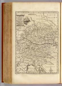
The South East Part of Germany
1 : 3500000 Mollova mapová sbírka Moll, Herman Moll, Hermann
S. R. I. Circulus Austriacus quem componunt Archid. Austriae, Ducatus Stiriae, Carinthiae, Carnioliae, Comit. Tyrolensis, ditionesque Sueviae austriacae, cum suis confiniis
1 : 1800000 Mayer, Tobias
S. R. I. Circvlvs Avstriacvs
1 : 1800000 Mollova mapová sbírka Mayer, Tobias Homann, Johann Baptista - dědici
S. R. I. circvlvs Avstriacvs quem componunt archid. Avstriae, dvcatvs Stiriae, Carinthiae, Carnioliae, comit. Tyrolensis, ditionesque Sveviae austriacae, cum suis confiniis
1 : 1730000 Korutansko (Rakousko) Mayer, Tobias curantibus Homannianis Heredibus
59-60. Cecoslovacchia, Ungheria.
1 : 1500000 Touring club italiano
Deutsch-Oesterreichische Länder
1 : 5000000 Österreich
Mapa Rakouska
1 : 2000000
[Süd-Östliches Deutschland]
Schul-Atlas über alle Theile der Erde nach dem neuesten Zustande, und über das Weltgebäude Stieler, Adolf Justus Perthes
[Rakousko]
1 : 2115000 Evropa střední
The south east part of Germany.
1 : 3500000 Moll, Herman, d. 1732
Bez titulu: Čechy

Republik Österreich
1 : 2000000 Rakousko R. Lechner (Wilh. Müller)
L'Empire, d'Allemagne
1 : 1200000 Mollova mapová sbírka Sanson, Nicolas Quasy, Robert
Routen und Manipulations-Karte der oesterr[eichischen] ungar[ischen] Eisenbahnen
Rakousko-Uhersko Stulík, František Nechvíle, Josef J. Farský
Karte der Republik Österreich
1 : 1500000 Wien : Kartographisches, früher Militärgeographisches Institut
Austrian Empire 1.
1 : 1774080 Letts, Son & Co.
Sbírka map a diagramů použitých na mírových konferencích v Paříži v letech 1919 - 1920

Übersichtskarte der territorialen Friedensbedingungen für Deutschösterreich
1 : 750000 Rakousko R. Lechner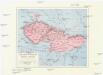
Les Pays Tchéques
Morava (Česko) Conseil National Tschécoslovaque
Maiestas Austriaca sive circ. archiducat. Austriae
1 : 3400000 Evropa střední Seutter, Matthäus Lotter, Tobias Conrad Tobias Conrad Lotter
Provincia Austriaca Societatis Iesu
1 : 1700000 Mollova mapová sbírka Seutter, Matthäus Mayr, Johann Baptist Seutter, Matthäus