Maps of Spain
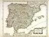
Spain and Portugal.
1 : 3500000 Bowen, Emanuel
Mapa general de España Antiqua, dividido en tres partes, Bética, Lusitánia y Tarraconénse, con la subdivision de cada una
1 : 3700000 por [...] Juan Lopez, pensionista de S.M [...] Madrid : [Thomas Lopez]
L'Espagne.
1 : 2600000 Mendez Sylva, Rodrigo
L'Espagne.
1 : 2600000 Mendez Sylva, Rodrigo
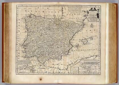
L'Espagne
1 Karte : Kupferdruck ; 47 x 59 cm L'Isle; Luchtenburg; Silva chez I. Covens et C. Mortier
Hispaniae Veteris Descriptio. [Karte] [Iulia Gaditana Aug. und Umgebung] [Nebenkarte], in: Novus atlas absolutissimus, Bd. 6, S. 8.
1 Karte aus Atlas Janssonius Offizin

Regni Hispaniae Post Omnium Editiones Locuplessima Descriptio. [Karte], in: Theatrum orbis terrarum, S. 48.
1 Karte aus Atlas Ortelius, Abraham
Carte de l'Espagne
1 Karte : Kupferdruck ; 46 x 59 cm L'Isle; Buache; Silva; Dezauche; Vallet chez Dezauche rue des Noyers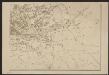
Hispaniae Veteris Descriptio.[Karte] [Iulia Gaditana Aug. und Umgebung] [Nebenkarte], in: Gerardi Mercatoris et I. Hondii Newer Atlas, oder, Grosses Weltbuch, Bd. 2, S. 207.
1 Karte aus Atlas Mercator, Gerhard und Hondius, Jodocus Jansson, Jan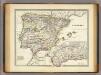
Hispania.
1 : 3800000 Menke, Th.
Regni Hispaniae Post Omnium Editiones Locuplessima Descriptio. [Karte], in: Theatrum orbis terrarum, S. 26.
1 Karte aus Atlas Ortelius, Abraham
Emirat von Cordoba bis zum Untergange der Ommijaden; christlichen Reiche im Norden der iberischen Halbinsel 711 bis 1028.
1 : 3700000 Spruner von Merz, Karl
Hispaniae Nova Descriptio, De Integro Multis In Locis, Secundum Hydrographicas Desc. Emendata. [Karte], in: Gerardi Mercatoris Atlas, sive, Cosmographicae meditationes de fabrica mundi et fabricati figura, S. 174.
1 Karte aus Atlas Mercator, Gerhard Montanus, Petrus
Hispania III. Nova Tabula [Karte], in: Geographia universalis vetus et nova complectens Claudii Ptolemaei Alexandrini enarrationis libros VIII, S. 308.
1 Karte aus Atlas Münster, Sebastian [und Ptolemaeus, Claudius]
Hispaniae Veteris Descriptio. [Karte] [Blastophoenices, Region Cádiz] [Nebenkarte], in: Theatrum orbis terrarum, S. 368.
1 Karte aus Atlas Ortelius, Abraham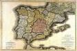
Carte routière des royaumes d'Espagne et de Portugal
1 Karte auf 2 Blatt : Kupferdruck ; 57 x 87 cm Jaillot; Longchamps; Basset; López; Basset chez Basset rue St. Jacques au coin de celle des Mathurins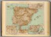
37-38. Spagna, Portogallo.
1 : 3000000 Touring club italiano
Tabula Moderna Hispanie [Karte], in: [Clavdii Ptholomei Cosmographi ...], S. 251.
1 Karte aus Atlas Nicolaus Germanus [und Ptolemaeus, Claudius]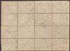
L'Espagne divisée en tous ses Royaumes Et Principautés [...] [Karte], in: Atlas nouveau, contenant toutes les parties du monde [...], Bd. 2, S. 107.
1 Karte aus Atlas Sanson, Nicolas Jaillot, Alexis Hubert und Mortier, Pieter
Reich der Westgothen, iberischen Halbinsel 477 bis 711.
1 : 3800000 Spruner von Merz, Karl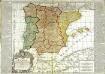
L'Espagne
1 Karte : Kupferdruck ; 48 x 56 cm, Bildgrösse 50 x 70 cm Bailleul; Daudet chez Daudet rue Merciere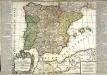
L'Espagne
1 Karte : Kupferdruck ; 49 x 56 cm, Bildgrösse 50 x 70 cm Bailleul; Daudet chez Daudet rue Merciere
Die iberische Halbinsel seit dem Anfange des XVIten. Jahrhundert's (1479).
1 : 3800000 Spruner von Merz, Karl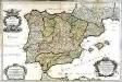
L'Espagne
1 Karte auf 2 Blatt : Kupferdruck ; 57 x 87 cm Sanson; Denis; Basset; Basset chés Basset rüe St. Jacques au coin de celle des Mathurins à l'image Ste. Genevieve
Die iberische Halbinsel nach ihrer kirchlichen Eintheilung.
1 : 3800000 Spruner von Merz, Karl

Hispania
1 Karte : Kupferdruck ; 48 x 55 cm L'Isle; Seutter; Silva Matthäus Seutter
Hispania III. Nova Tabula [Karte], in: Claud. Ptolemaeus. Geographia lat. cum mappis [...], S. 338.
1 Karte aus Atlas Münster, Sebastian [und Ptolemaeus, Claudius]