Maps of Catamarca

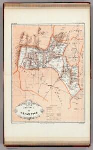
Provincia de Catamarca.
1 : 1800000 Paz Soldan, Mariano Felipe, 1821-1886
Provincia de La Rioja.
1 : 1800000 Paz Soldan, Mariano Felipe, 1821-1886
Demarcacion de limites con Chile. Plano general de la sub-comision n°1. Hoja n°I
1 : 500000 Argentine. Oficina de Límites Internacionales [Buenos Aires ?] :
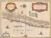
Catamarca et Tucuman.
1 : 1850000 Martin de Moussy, V. (Victor), 1810-1869
Carte des Provinces de Catamarca de Rucuman et des régions voisines
1 : 2000000 Description géographique et statistique de la Confédération Argentine Martin de Moussy, Victor Librairie de Firmin Didot frères, fils et Cie
Carte des Provinces de la Rioja de San Juan et des régions voisines
1 : 2000000 Description géographique et statistique de la Confédération Argentine Martin de Moussy, Victor Librairie de Firmin Didot frères, fils et Cie
Carte, provinces de La Rioja et San Juan.
1 : 1850000 Martin de Moussy, V. (Victor), 1810-1869
Provincia de La Rioja
1 : 1250000 Seelstrang, Arthur Eduard von 1838-1896 Buenos-Aires : J. Ruland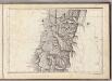
(Mapa de la Republica de Chile 3)
1 : 11000000 Pissis, Aime, 1812-1889
Provincia de San Juan.
1 : 1800000 Paz Soldan, Mariano Felipe, 1821-1886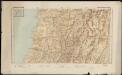
Republica de Chile [27°-29° S]
1 : 500000 (Chili) Oficina de Mensura de Tierras Santiago du Chili : Oficina de Mensura de Tierras
Demarcacion de limites con Chile. Puna de Atacama.
1 : 500000 Argentine. Oficina de Límites Internacionales [Buenos Aires ?] :
CHILI
[Amsterdam : Joan Blaeu]

Geographisch-statistische und historische Charte von Chile
1 : 3500000 Weimar : Verlag des Geographischen Instituts
Chili [Karte], in: Theatrum orbis terrarum, sive, Atlas novus, Bd. 2, S. 362.
1 Karte aus Atlas Blaeu, Joan Blaeu, Willem Janszoon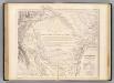
Carte, Province de Santiago del Estero, Grand Chaco.
1 : 1850000 Martin de Moussy, V. (Victor), 1810-1869
Partie, la Plata. Amer. Merid. 30.
1 : 1641836 Vandermaelen, Philippe, 1795-1869
Composite: Mapa de la Republica de Chile (1-8)
1 : 11000000 Pissis, Aime, 1812-1889
Partie du Chili. Amer. Merid. 29.
1 : 1641836 Vandermaelen, Philippe, 1795-1869
Carte des Provinces de Cordova de San Luis et des régions voisines
1 : 2000000 Description géographique et statistique de la Confédération Argentine Martin de Moussy, Victor Librairie de Firmin Didot frères, fils et Cie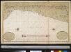
Een gedeelte van de Zuijdt-Zee van Quilca tot Po. El Guasco geleegen aen de kust van Peru
Chile Gerard van Keulen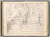
Carte des provinces de Cordova et San Luis.
1 : 1850000 Martin de Moussy, V. (Victor), 1810-1869
Carte de la Province de Santiago del Estero et du Territoire Indien du Nord ou Grand Chaco
1 : 2000000 Description géographique et statistique de la Confédération Argentine Martin de Moussy, Victor Librairie de Firmin Didot frères, fils et Cie
Carta de la rejion salitrera comprendida entre los paralelos 19° y 27°30' lat. sur
1 : 500000 (Chili) Delegacion fiscal de salitreras Antofagasta : Delegacion fiscal de salitreras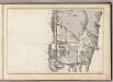
(Mapa de la Republica de Chile 2)
1 : 11000000 Pissis, Aime, 1812-1889
Provincia de Santiago del Estero.
1 : 1800000 Paz Soldan, Mariano Felipe, 1821-1886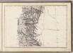
(Mapa de la Republica de Chile 4)
1 : 11000000 Pissis, Aime, 1812-1889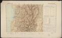
Republica de Chile [29°-31° S]
1 : 500000 (Chili) Oficina de Mensura de Tierras Santiago du Chili : Oficina de Mensura de Tierras