Maps of Germany

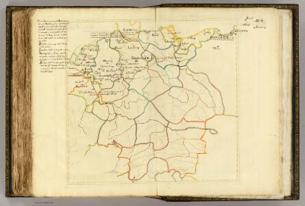
(Villes Anseatiques)
1 : 2900000 Dangeau, abbe de, 1643-1723
Neueste Post Karte von ganz Deutschland
1 : 1460000 Evropa střední Müller, Franz Artaria
L'Allemagne 1373 a 1437.
1 : 6300000 Houze, Antoine Philippe
L'Allemagne 911 a 1024.
1 : 6300000 Houze, Antoine Philippe
La Germanie a la fin du 5e. siecle.
1 : 6300000 Houze, Antoine Philippe
L'Allemagne 1137 a 1273.
1 : 6300000 Houze, Antoine Philippe
L'Allemagne, l'Autriche, la Prusse et la Pologne 1612 a 1788.
1 : 6300000 Houze, Antoine Philippe
CARTE de L'ALLEMAGNE POLITIQUE ACTUELLE a partir du CONGRES de VIENNE ou CONFÉDÉRATION GERMANIQUE, renfermant occasionellement la CONFÉDÉRATION SUISSE
Německo Hacq P. Renouard
Germany, Austria.
1 : 4118400 Letts, Son & Co.
L'Allemagne 1024 a 1137.
1 : 6300000 Houze, Antoine Philippe
L'Allemagne 1437 a 1612.
1 : 6300000 Houze, Antoine Philippe
Societas Iesu Germana
1 : 2600000 Mollova mapová sbírka Seutter, Matthäus Seutter, Matthäus
Autriche, Prusse, Confed. Germanique, Pologne 1788 a 1841.
1 : 6300000 Houze, Antoine Philippe
Neueste Post-Karte von Deutschland und den angrenzenden Laendern
1 : 1700000 Maďarsko Mollo, Tranquillo T. Mollo
La Germanie 741 a 843.
1 : 6300000 Houze, Antoine Philippe
Europe Centrale.
1 : 3000000 Garnier, F. A., 1803-1863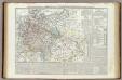
Carta generale della Germania ossia Confederazione Germanica.
1 : 3500000 Marzolla, Benedetto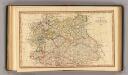
Central states Europe.
1 : 9000000 Fenner, Rest.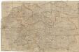
Neueste und vollstaendigste Post Karte von ganz Deutschland Niederlanden Schweiz Pohlen Ungarn und den angränzenden Theilen Frankreichs u Italien
Evropa střední Cappi, Jean Jean Cappi
Der Deutsche Bund samt der Helvetischen Eidgenossenschaft aft. 1828
Historisch-genealogisch-geographischer Atlas von Le Sage Las Cases, Emmanuel Auguste Dieudonné Marius Joseph de Johann Velten, Kunsthändler
Germany
A new general atlas of modern geography, consisting of a complete collection of maps of the four quarters of the globe Wyld, James James Wyld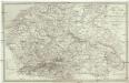
Post Karte von Deutschland in zwey Blättern
1 : 1920000 Německo Schindelmeyer, Karl Robert Ludwig Mairisch
Europe Centrale.
1 : 4100000 Montemont, A.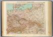
51-52. Germania, Polonia, Cecoslovacchia, Austria, Ungheria.
1 : 3000000 Touring club italiano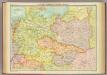
Central European states - political.
1 : 3000000 John Bartholomew and Son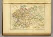
l'Allemagne par Cercles in 1789.
1 : 6300000 Malte-Brun, Conrad, 1775-1826
Karte des Deutschen Reichs
Schmidt, Johann Marius Friedrich; Jäck Schropp
L'Allemagne 843 a 911.
1 : 6300000 Houze, Antoine Philippe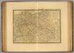
Europe Centrale.
1 : 3500000 Picquet, C.