Maps of Appalachian Mountains

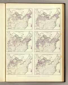
British American, English, Welsh, Swedish, Norwegian population 1870.
1 : 14300000 United States. Census Office; Walker, Francis Amasa, 1840-1897
A map of the United States of America, as settled by the peace of 1783.
from Whole Publish[e]d by I. Fielding, Pater-noster Row: [London],
A map of the United States of America, as settled by the peace of 1783.
from Whole Publish[e]d ... by I. Fielding, Pater-noster Row: [London]; Andrews, John,
An accurate map of the United States of America: according to the Treaty of Peace of 1783.
from Whole Published as the Act directs by H.D. (Henry Delahoy) Symonds: London; Russell, John,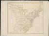
United States of America

United States of America.
1 : 1960000 Tanner, Henry S.
3. Population 1800.
1 : 16500000 Gannett, Henry, 1846-1914; United States. Census Office
7. Population 1840.
1 : 16500000 Gannett, Henry, 1846-1914; United States. Census Office
4. Population 1810.
1 : 16500000 Gannett, Henry, 1846-1914; United States. Census Office
8. Population 1850.
1 : 16500000 Gannett, Henry, 1846-1914; United States. Census Office
9. Population 1860.
1 : 16500000 Gannett, Henry, 1846-1914; United States. Census Office
5. Population 1820.
1 : 16500000 Gannett, Henry, 1846-1914; United States. Census Office
6. Population 1830.
1 : 16500000 Gannett, Henry, 1846-1914; United States. Census Office
2. Population 1790.
1 : 16500000 Gannett, Henry, 1846-1914; United States. Census Office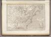
Etats Unis et Canada.
1 : 8400000 Montemont, A.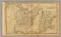
United States.
1 : 11700000 Adams, Daniel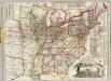
Watson's new rail-road and distance map of the United States and Canada.
1 : 2344320 Watson, Gaylord
Lay's map of the United States / compiled from the latest and best authorities and actual surveys by Amos Lay, geographer and map publisher ; engraved by O.H. & D.S. Throop & Wm. Chapin.
from Whole
4. Population 1830-1860.
1 : 8450000 Gannett, Henry, 1846-1914; United States. Census Office
3. Population 1790-1820.
1 : 8450000 Gannett, Henry, 1846-1914; United States. Census Office
Foreign population 1870.
1 : 7200000 Walker, Francis Amasa, 1840-1897
US Population 1850.
1 : 7100000 Walker, Francis Amasa, 1840-1897
Illiteracy 1870.
1 : 7100000 Walker, Francis Amasa, 1840-1897
Enteric, cerebro-spinal, typhus deaths.
1 : 7200000 Walker, Francis Amasa, 1840-1897
Foreign parentage 1870.
1 : 7100000 Walker, Francis Amasa, 1840-1897
Colored population proportion 1870.
1 : 7100000 Walker, Francis Amasa, 1840-1897
White male illiteracy.
1 : 7100000 Walker, Francis Amasa, 1840-1897
Predominating sex US.
1 : 7200000 Walker, Francis Amasa, 1840-1897
US Population 1860.
1 : 7100000 Walker, Francis Amasa, 1840-1897
US Population 1790-1820.
1 : 14300000 Walker, Francis Amasa, 1840-1897
Public indebtedness US.
1 : 7200000 Walker, Francis Amasa, 1840-1897
Consumption deaths US.
1 : 7200000 Walker, Francis Amasa, 1840-1897
Intestinal diseases deaths US.
1 : 7200000 Walker, Francis Amasa, 1840-1897
Malarial deaths US.
1 : 7200000 Walker, Francis Amasa, 1840-1897
Taxation per capita US.
1 : 7200000 Walker, Francis Amasa, 1840-1897
Wealth distribution US.
1 : 7200000 Walker, Francis Amasa, 1840-1897
Foreign population proportion 1870.
1 : 7200000 Walker, Francis Amasa, 1840-1897
Irish, German population 1870.
1 : 14300000 Walker, Francis Amasa, 1840-1897
Foreign parentage proportion 1870.
1 : 7100000 Walker, Francis Amasa, 1840-1897
Farms, production, corn, dairy.
1 : 14300000 Walker, Francis Amasa, 1840-1897
Crops US.
1 : 14300000 Walker, Francis Amasa, 1840-1897
Birth rate US.
1 : 7200000 Walker, Francis Amasa, 1840-1897