Maps of North Holland
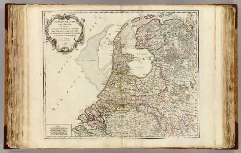
Provinces-Unies des Pays-Bas.
1 : 555000 Robert de Vaugondy, Gilles, 1688-1766
Amsterdam, Haag, Flensburg, Memel
1 : 750000 Amsterdam (Nizozemsko) Kohout, F. K. u. k. Militärgeographisches Institut
Amsterdam, Haag, Flensburg, Memel
1 : 750000 Amsterdam (Nizozemsko) K. k. militär-geographisches Institut
De VII veerenigde nederlandsche Provinciën
Nizozemsko Sepp, Jan Christiaan Sepp, Christian Andreas Christiaan Sepp en Zoon
Übersichtskarte von Mittel - Europa

Übersichtskarte von Mittel - Europa

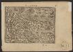
Holand
1 : 900000 [Sebastian Münster] [Basel] : [Heinrich Petri]
Holandt
1 : 900000 [Sebastian Münster] [Basel] : [Heinrich Petri]
Bescrivinge van dat vermarde en vruchtbaer graefschap van Hollant met dat geheele landt van Utrecht, dese landen sin eertiets bij den ouden Romeinen Batavia genaemt geweest, waer af dat het landt tusschen den Rhin ende de Wael noch tertiet den naem Betue behouden heeft, want gelick men noch tegenwordich sien can dat den Rhin in voerleden tijden doer Utrecht ende de stadt Leijden also sijnen cours oft loop aldaer inde zee genomen heeft, bij dat huus te Bretta, waer vã noch somige rowinen oft oude muragien inde zee liggê die welcke bij onsen tydê dry mael gesien sin te wetê int jaer 1520 eñ 1552 1562
1 : 400000 Joannes à Duetecum, Lucas à Duetecum fecerunt Nieumegen. [S.l.] : [s.n.]
Nuova carta della contea di Olanda
1 : 700000 Frano. Sesone sculp. [Napoli] : [Francesco Ricciardo]
Nuova carta della contèa di Olanda
1 : 700000 [Giambatista Albrizzi] [Venezia] : [Giambatista Albrizzi]
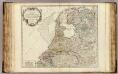
Hollandia
1 : 800000 [Pieter van den Keere engraver] [Amsterdam] : [Guglielmo de Jonge]
Hollandia
1 : 800000 [Pieter van den Keere engraver] [Amsterdam] : [Jan Evertsz. Cloppenburgh]
Holãd
1 : 900000 [Sebastian Münster] [Basel] : [Heinrich Petri]
Holãd
1 : 900000 [Sebastian Münster] [Basel] : [Heinrich Petri]
Holand
1 : 900000 [Sebastian Münster] [Basel] : [Heinrich Petri]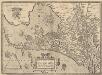
Hollandiae Antiquorum Catthorum Sedis Nova Descriptio [Karte], in: Theatrum orbis terrarum, S. 192.
1 Karte aus Atlas Ortelius, Abraham Vrients, Jan Baptista
Pas caart van de Zuyder-Zee
1 Karte : Kupferdruck ; 43 x 52 cm Doncker by Hendrick Doncker inde Nieuwbrughsteegh in 't Stuurmans gereedschap
Hollandiae Batavor[um] veteris insulae et locorum adjacentium exacta descriptio
1 : 400000 [Jacob van Deventer] Jac. Bossius Baelga, in ae incidebat. Amsterdam : Frederik Muller & Co.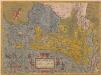
Hollandiae Antiquorum Catthorum Sedis Nova Descriptio [Karte], in: Theatrum orbis terrarum, S. 52.
1 Karte aus Atlas Ortelius, Abraham
Ontwerp tot indijking en droogmaking van het zuidelijk gedeelte der Zuiderzee.
1 : 200000 [Leiden] : [Hooiberg]
Pars I Frisiae Liberae quae Westfresia post eluviones seculi XIII
1 : 370000 auctore Menso Alting Ger. de Broen fecit. [Amstelaedami] : [apud Henricum Wetstenium]
Paskaarte van de Zuyder Zee met alle des zelfs inkomende gaaten, soo als die op't zeekerts konnen bezeyld worden: naa haare correkte course, opdoeningen, droogten en diepten
1 : 200000 Tot Amsterdam : by Joannis van Keulen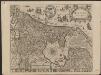
Hollandia Comitatus
1 : 550000 [Willem Jansz. Blaeu] Josua vanden Ende sculpsit. T'Amsterdami : by Rombout van den Hoeye
Comitatus Hollandia = ’t Graefschap Hollandt
1 : 400000 van nieus verb. ende verm. door Willem Janszoon [Blaeu] Josua vanden Ende sculpsit. Amsterdam : ghedruckt bij Willem Jansz. op 't water inde Sonnewijser
Hollandia Comitatus in ejusdem sujacentes ditiones : una cum toto Ultrajectino Domino, nec non maximis partibus Geldriae Ducatus, Frisiae Comitatus aliarumq vicinarum provinciarum foederatum exactissimè delinatus / per Nicolaum Visscher ; G. Gouwen sculps.
1 : 300000 titelvariant: Landkaart vertonende het graafschap Holland ...; Annotatie: Titel boven de kaart: Landkaart vertonende het graafschap Holland; Uit: Atlas minor, sive totius orbis terrarum. - Amstelaedami : apud Nicolaum Visscher, [na 1705]; Met privilege Visscher, Nicolaes (1649-1702); Gouwen, G. Amsterdam : Nicolaus Visscher
Hollandia
1 : 1100000 [Zacharias Heyns] [Amsterdam] : [Zacharias Heyns]
Kaart van de Zuiderzee met derzelver boorden langs de provinciën Vriesland, Overijssel, Gelderland, Utrecht en Noordholland
1 : 150000 opgemaakt uit de beste voorhanden zijnde kaarten door D.J. Thomkins, oud Hoofd-Ingenieur van den Waterstaat gegraveerd door Dl. Veelwaard. Moordrecht : D.J. Thomkins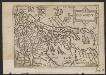
Ollandt
1 : 1800000 [Scipion Banca] [Venetia] : [per Scipion Banca]