Maps of Suffolk County

Boston Harbor.
1 : 73000 Haynes, Tilly
Boston Bay quadrangle, Massachusetts
1 : 62500 Geological Survey (U.S.) U.S. Geological Survey
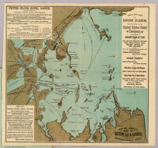
Boston Harbor : showing the steamboat routes to places of amusement
1 : 63360 Daniels, J. H. (John H.), 1828-1901 J.H. Daniels
Boston Bay quadrangle, Massachusetts
1 : 62500 Geological Survey (U.S.) U.S. Geological Survey
Boston Harbor, Massachusetts.
1 : 40000 United States Coast Survey
Boston Harbor.
1 : 57000 Good, Charles E.
Boston Bay
1 : 62500
Boston Bay
1 : 62500
Boston Bay
1 : 62500
Boston Bay
1 : 62500
Boston Bay
1 : 62500
Boston Bay
1 : 62500
Boston Bay
1 : 62500
Boston Bay
1 : 62500
Boston Bay
1 : 62500
Boston Bay
1 : 62500
Boston Bay
1 : 62500
Boston Bay
1 : 62500
Boston Bay
1 : 62500
38. Boston Bay sheet.
1 : 62500 Massachusetts. Topographical Survey Commission
Chart of Boston Harbor : from the best authorities
1 : 85000 Dearborn, N. S. (Nathaniel S.) N.S. Dearborn
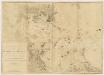
Chart of Boston Harbour, surveyed in 1817
1 : 18000 Wadsworth, Alexander Melish, John
A new and accurate plan of the town of Boston in New England; A new plan of Boston Harbor from an actual survey
Hinton, John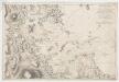
Carte particulière du havre de Boston : avec les sondes les bancs de Sable, les rochers les Amaies et les autres directions utiles à la navigation
1 : 33000 Chabert, Joseph Bernard, marquis de, 1724-1805 Dépôt des cartes et plans de la marine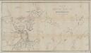
Map of Boston Harbor : showing Commissioners' lines, wharves &c
1 : 20000 Chesbrough, Ellis Sylvester, 1813-1886 Tappan & Bradford's Lith.
Chart of Boston Harbour : surveyed in 1817
1 : 18000 Wadsworth, Alexander S John Melish
Carte de la ville, baye et environs de Baston

Rail road map : showing the street rail road routes in and leading from Boston, with the terminus of each road in suburban cities or towns
1 : 42240 Chase, J. G J.H. Bufford
Boston Harbor
Geo. H. Walker & Co.