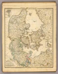
Maps of Denmark

Daenemark, Schleswig-Holstein u. Lauenburg.
1 : 1000000 Stein, Christ. Gottfr. Dan.
Denmark.
1 : 1400000 Hughes, William
Denmark.
1 : 840000 Arrowsmith, John
Denmark.
1 : 1800000 Darton, William
Post Karte von Daenemark nach Meilen
Dánsko Hallberg, von Santjohanser, N.
Danemark.
1 : 1290000 Migeon, J.
[Neuer Atlas der ganzen Erde nach den neuesten Bestimmungen ... : XIII.] Der Daenische Staat und die Gebiete der freien Städte Hamburg und Lübeck
Entworfen und gezeichnet von Dr. F.W. Streit H. Leutemann sc. Leipzig : J.C. Hinrichs'sche Buchhandlung
Denmark.
1 : 1800000 Mitchell, Samuel Augustus
Denmark.
1 : 1800000 Mitchell, Samuel Augustus
Daniae regnum cum ducatu Holsatiae et Slesvici nec non insulae Danicae et Iutia cum parte Scaniae
1 : 941000 Dánsko Lotter, Tobias Conrad studio Tobiae Conradi Lotteri
Königreich Dänemark 1648 und die Herzogtümer Schleswig und Holstein
Dänemark, Herzogtum Schleswig Kunz, Andreas ; Moeschl, Joachim Robert
Denmark with Schleswig & Holstein.
1 : 1330560 Fullarton, A. & Co.
Denmark, Alsace-Lorraine, Palatinate.
1 : 1500000 Andree, Richard; Times (London, England)
Denmark, Sleswig, Holstein.
1 : 823680 Stanford, Edward
Dänemark mit Schleswig, Holstein
Dánsko

Regni Daniae in quo sunt ducatus Holsatia et Slesvicum, insulæ Danicæ provinciæ Iutia Scania Blekingia nova tabula
1 Karte : Kupferdruck ; 47 x 55 cm Homann Johann Baptist Homann
Regni Daniae in quo sunt ducatus Holsatia et Slesvicum, insulæ Danicæ provinciæ Iutia Scania Blekingia nova tabula
1 Karte : Kupferdruck ; 47 x 56 cm Homann; Hübner Johann Baptist Homann
Regni Daniae in quo sunt ducatus Holsatia et Slesvicum insulæ Danicæ provinciæ Iutia Scania Blekingia nova tabula
1 Karte : Kupferdruck ; 47 x 56 cm Homann; Hübner Johann Baptist Homann
Denmark
A new general atlas of modern geography, consisting of a complete collection of maps of the four quarters of the globe Wyld, James James Wyld
Charte des Königreichs Daenemark, nach Murdochischer Projection und nach den trigonometrischen Charten der König
1 : 919000
Daenemark, Island.
1 : 875000 Weiland, C. F. (Carl Ferdinand), d. 1847
Denmark.
1 : 1840000 Tanner, Henry S.
Denmark.
1 : 1820000 Tanner, Henry S.
Daniae Reg. cum Ducatu Holsatiae et Slesvici
1 : 500000 Weyerman, Jacob Campo
Denmark.
1 : 1850000 Lucas, Fielding Jr.
Dänemark, Schleswig, Holstein u. Lauenburg, nebst den Dänischen Colonien
Hand-Atlas über alle Theile der Erde und über das Weltgebäude Stieler, Adolf Justus Perthes
[Dänemark und die Dänischen Kolonien]
Handatlas über alle Theile der Erde und über das Weltgebäude Stieler, Adolf Justus Perthes