Maps of Monterey County

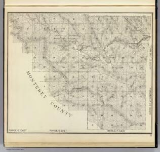
R.12-14E T.21-22S.
1 : 63360 Thompson, Thos. H.
Smith Mountain
1 : 24000
Smith Mountain
1 : 24000
Curry Mountain
1 : 24000
Curry Mountain
1 : 24000
Priest Valley
1 : 62500
Priest Valley
1 : 62500
Priest Valley
1 : 62500
Priest Valley
1 : 62500
Slack Canyon
1 : 24000
Slack Canyon
1 : 24000
Stockdale Mountain
1 : 24000
Stockdale Mountain
1 : 24000
Stockdale Mountain
1 : 24000
Coalinga
1 : 100000
Priest Valley
1 : 125000
Priest Valley
1 : 125000
Priest Valley
1 : 125000
Priest Valley
1 : 125000
Coalinga
1 : 62500
Coalinga
1 : 62500
Parkfield
1 : 24000
Parkfield
1 : 24000
Parkfield
1 : 24000
Parkfield
1 : 31680
Parkfield
1 : 24000
San Miguel
1 : 62500
San Miguel
1 : 62500
San Miguel
1 : 62500
San Miguel
1 : 62500
San Miguel
1 : 62500
San Miguel
1 : 62500