Maps of Grand Est

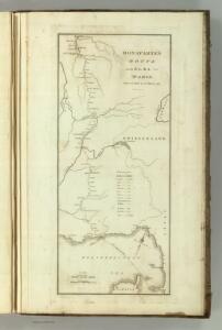
Bonaparte's Route from Elba to Paris.
1 : 2500000 Melish, John
[Helvetien]
1 : 3100000 1 Karte entworfen von F.L. Güssefeld ; gestochen von C. Westermayr [im Verlage des Industrie Comptoirs], [Weimar]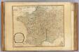
France, governments.
1 : 2250000 Robert Laurie & James Whittle
[Helvetien]
1 : 3100000 1 Karte entworfen von F.L. Güssefeld ; gestochen von J.C. Müller [im Verlage des Industrie Comptoirs], [Weimar]
<<A>> new & accurate map of Switzerland with its allies and subjects
1 : 1700000 1 Karte composed from ey. most approv'd maps &c and regulated by astronom. observat. by Emanl. Bowen [printed for William Innys ...], [London]
Carta noua accurata del paßagio et strada dalli Paesi Baßi per via de Allemagna per Italia et per via di paesi Suizeri a Geneua, Lione et Roma per seruizio delli marchanti et viagianti in gen.ale ad instanza delli Ss. scherer et di Momforti speditori delli marchantie in Bregens
1 : 2060000 Itálie Wit, Frederik de Frederico de Wit
Carte de Suisse suivant sa nouvelle division en XVIII cantons formant la république helvétique
1 Karte in 2 Teilen auf 1 Bl. dressée par H. Mallet ; Emery sc. [chez F. Monty], [Genève]
Helvetiae descriptio
1 Karte Aegidio Tschudo auct. ; [Abraham Ortelius fecit] [en la emprenta de Roberto Bruneau?], [Anveres]
Le Theatre de Bellone :
Mollova mapová sbírka Schenk, Pieter Braakman, Adriaan
Nejnovější mapa bojiště německo - francouzského

Geognostische Karte der Alpen in Savoyen und der Schweitz in einem Theile von Deutschland, Frankreich, Piemont und der Lombardei
1 : 1300000 1 Karte gez. von F. Schoedinger ; gest. von J. Scheurman [Orell, Füssli und Compagnie], [Zürich]
17-19. Alpi fisiche.
1 : 1500000 Touring club italiano
France.
1 : 4400000 Vivien de St Martin, L.
Alpengebiet
Volksschul-Atlas über alle Teile der Erde Lange, Henry Druck und Verlag von Georg Westermann
Nova Germaniae
1 : 3420000 Belgie
[Frankreich, Blatt 2]
Adolf Stieler's Handatlas über alle Theile der Erde und über das Weltgebäude Stieler, Adolf Justus Perthes
United Provinces.
1 : 1670000 Seaman, James V.
Le Cours De La Riviere Du Rhein depuis sa Source jusques a son Emboucheure [...] [Karte], in: Atlas nouveau, contenant toutes les parties du monde [...], Bd. 1, S. 166.
1 Karte aus Atlas Sanson, Nicolas Jaillot, Alexis Hubert und Mortier, Pieter
Helvetia
1 : 2500000 1 Karte [ed.: Giovanni Antonio Magini] [Petrus Keschedt], [In celeberrima Agrippinensium Colonia]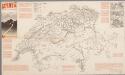
[Recto], uit: Schweiz : offizielle Strassenkarte
1 : 450000 Annotatie: Met 8 plattegronden en toeristische informatie Zürich : Schweiz. Verkehrszentrale
Helvetia
1 : 2500000 1 Karte [ed.: Alphons Lasor a Varea] [Verlag nicht ermittelbar], [Patavii]
Switzerland
1 : 850000 1 Karte engraved by George Philip & Son Philip & Son, Liverpool
Helvetia
1 : 4200000 1 Karte Aegidio Tschudo auctore [de l'Imprimérie de Christofle Plantin], [Anvers]
Nova Rhaetiae atque totius Helvetiae descriptio
1 : 350000 1 Karte auf 10 Bl. per Aegidium Tschudum Glaronensem Hofer & Burger, Zürich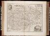
Comitatus Burgundiae, ou la Franche Comté / [Joannes Janssonius]
1 : 650000 Annotatie: Oorspr. verschenen in: Joannis Janssonii Atlantis majori ... - Amstelodami : apud Ioannem Ianssonium, 1675; Origineel is Blad 20 in atlas factice; Annotatie geografische gegevens: Zuidoost boven Janssonius, Joannes (jr.) (1588-1664) Amstelodami : sumptibus Ioannis Ianssonii
Assemblage de l' atlas Suisse.
From Atlas Suisse. Levé et dessiné par J. H. Weiss aux fraix de J. R. Meyer á Aarau dans les années 1786 á 1802. Gravée par Guerin, Eichler, et Scheurmann.
Geognostische Karte der Alpen in Savoyen und der Schweitz in einem Theile von Deutschland, Frankreich, Piemont und der Lombardei
1 : 1300000 1 Karte gez. von F. Schoedinger ; gest. von J. Scheurman [Orell, Füssli und Compagnie], [Zürich]
Helvetia
1 : 2500000 1 Karte [appresso P. & F. Galignani], [Padova]
[Helvetia]
1 : 700000 1 Karte auf 2 Bl. Paulus de Forlanis [Forlani], Venetij