Maps of Cambridge

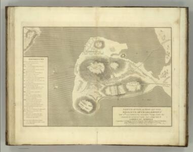
Sketch of the Action on the Heights of Charlestown.
Melish, John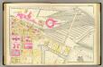
11. Ward 1.
1 : 1200 Bromley, George Washington; Bromley, Walter Scott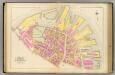
4. Ward 6.
1 : 1200 Bromley, George Washington; Bromley, Walter Scott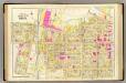
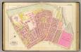
12. Wards 1-3.
1 : 1200 Bromley, George Washington; Bromley, Walter Scott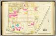
10. Wards 1-2.
1 : 1200 Bromley, George Washington; Bromley, Walter Scott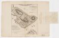
A plan of the action at Bunkers Hill on the 17th of June 1775 between His Majesty's troops, under the command of Major General Howe, and the American forces (without overlay)
1 : 4800 Page, Thomas Hyde, Sir, 1746-1821 Published by the author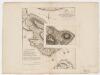
A plan of the action at Bunkers Hill on the 17th of June 1775 between His Majesty's troops, under the command of Major General Howe, and the American forces (with overlay)
1 : 4800 Page, Thomas Hyde, Sir, 1746-1821 Published by the author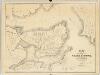
Plan of the city of Charlestown : made by order of the City Council from actual survey
1 : 4800 Felton & Parker J.H. Bufford's Lithogy.
Boston and Adjacent Cities.
1 : 20000 Colton, G.W.
Boston with Charlestown and Roxbury

Boston, Birthplace of the Telephone : A Pictorial Map of the Down Town Area
Chase, Ernest Dudley, 1878-1966
An accurate plan of the town of Boston and its vicinity : exhibiting a ground plan of all the streets, lanes, alleys, wharves, and public buildings in Boston, with the names and description thereof, likewise all the flats and channels between Boston and Charlestown, Cambridge, Roxbury & Dorchester with the two bridges and causeway, and the boundary lines beween Boston and the above mentioned towns from ...
1 : 4170 Carleton, Osgood, 1742-1816 Published and sold by Osgood Carleton
A rough and innacurate sketch of the streets of Boston as they are supposed to have been first laid out & the owners of the soil, from 1630 to 1650 or thereabouts

Plan of Boston

A new and correct plan of the town of Boston

Map of Boston proper
6. Ward 8.
1 : 1200 Bromley, George Washington; Bromley, Walter Scott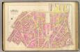
5. Wards 6, 8.
1 : 1200 Bromley, George Washington; Bromley, Walter Scott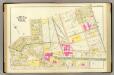
9. Wards 2-4.
1 : 1200 Bromley, George Washington; Bromley, Walter Scott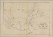
Rail-road crossings and termini in the vicinity of Boston : compiled under the direction of the commissioner appointed by the governor to report upon a plan or plans for avoiding said crossings
1 : 7200 Perkins, Charles E., 1951- Tappan & Bradford's Lithogy.
Boston and Adjacent Cities.
1 : 19500 Colton, G.W.
Boston.
1 : 13000 Haynes, Tilly
A plan of those parts of Boston and the towns in its vicinity : with the waters and flats adjacent which are immediately or remotely connected with the contemplated design of erecting perpetual tide-mills
1 : 15840 Dearborn, Benjamin, 1754-1838 Benjamin Dearborn
Boston and Adjacent Cities.
1 : 19500 Colton, G.W.
Plan of Boston.
from Mitchell's new general atlas, containing maps of the various countries of the world, plans of cities, etc., embraced in fifty-three quarto maps., forming a series of eighty four maps and plans, together with valuable statistical tables.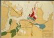
Map of Boston Inner Harbor
1 : 7210 Massachusetts. Directors of the Port of Boston Massachusetts. Directors of the Port of Boston
Plan of Boston and its vicinity showing the connection of the Grand Junction Rail Road with the Harbor and other Rail-roads
1 : 37500 Tappan & Bradford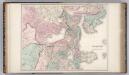
Boston and Vicinity.
1 : 19400 Gray, Ormando Willis
Plan of the town of Boston and circumjacent country shewing the present situation of the Kings troops & the Rebels Intrenchments 25th July 1775
D'Auvergne, Philip, Prince de Bouillon