Maps of Massachusetts

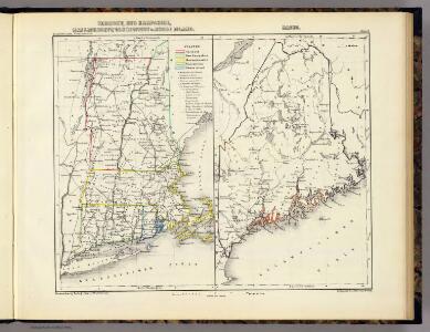
Vermont, New Hampshire, Massachusetts, Connecticut u. Rhode Island. Maine.
1 : 2700000 Lange, Henry, 1821-1893.
Vermont, New Hampshire, Massachusetts, Rhode Island, and Connecticut.
1 : 1077000 Johnson, A.J.
199. New England. The World Atlas.
1 : 125000 USSR (Union of Soviet Socialist Republics).
Post route map of the states of New Hampshire, Vermont, Massachusetts, Rhode Island, Connecticut, and parts of New York and Maine
1 : 380160 Nicholson, Walter L. United States. Post Office Dept.
Post route map of the states of New Hampshire, Vermont, Massachusetts, Rhode Island, Connecticut, and parts of New York and Maine
1 : 380160 Nicholson, W. L. United States. Post Office Dept.
Travel-map of New England
1 : 304000 Guyde Publishing Company
Massachusetts and Rhode Island.
from The cerographic atlas of the United States. By Sidney E. Morse, A.M., and Samuel Breese, A.M.
The north eastern coast, North America, New York to Cape Canso (west sheet)
1 : 910000 Wadsworth, A. S. (Alex. S.)
The New England commercial and route survey
National map of the American Republic.
from Whole
New Hampshire and Vermont.
from New general atlas.
Vermont and New Hampshire.
from Supplement to the New York observer.
Carte de la Nouvelle Angleterre, comprenant les etats de Massachusets Bay, N. Hamp Shire, Connecticut et Rhode Island

Vermont and New Hampshire.
1 : 610000 Johnson, A.J.
Vermont and New Hampshire.
1 : 610000 Johnson, A.J.
A new map of New Hampshire
1 : 810000 Belknap, Jeremy, 1744-1798 Bradford and Read
Township map of the states of New Hampshire and Vermont
1 : 596000 G.W. & C.B. Colton & Co G.W. and C.B. Colton & Co.
A map of the most inhabited part of New England containing the provinces of Massachusets Bay and New Hampshire with the colonies of Connecticut and Rhode Island divided into counties and townships the w[h]ole composed from actual surveys ...

A map of the most inhabited part of New England, containing the provinces of Massachusets Bay and New Hampshire, with the colonies of Connecticut and Rhode Island, divided into counties and townships, the whole composed from actual surveys ...

Shell Highway Map of New Hampshire, Vermont.
1 : 570240 Shell Oil Company
New Hampshire by recent survey : made under the supreme authority and published according to law
1 : 200000 Carrigain, Philip, 1772-1842 Philip Carrigain
To the honourable Walter Younge, barronet, one of the commissioners for his majestie's collonis : this description of New England in America is most humbly dedicated & presented by your hombl., faithfull & obedient servt
1 : 2200000 Hacke, William
New England and New York in 1697

Railroad Map Featuring Many Northeastern States Rhode Island Connecticut Massachusetts
1 : 2000
Map exhibiting the Farmington & Hampshire & Hampden canals : together wth the line of their proposed continuation through the valley of the Connecticut River to Canada / engraved and published by N. & S.S. Jocelyn.
from Parts
A map of New Hampshire.
from The American geography; or, A view of the present situation of the United States of America: containing astronomical geography; geographical definitions, discovery, and general description ... By Jedidiah Morse, A.M.
Vermont And New Hampshire.
1 : 610000 Johnson, A.J.
Neueste Karte von New Hampshire und Vermont
Grosser Hand-Atlas über alle Theile der Erde in 170 Karten Meyer, J. Verlag des Bibliographischen Instituts
N.H., Vt.
1 : 910000 Rand McNally and Company
New Hampshire & Vermont.
1 : 885000 Mitchell, Samuel Augustus