Maps of Romania
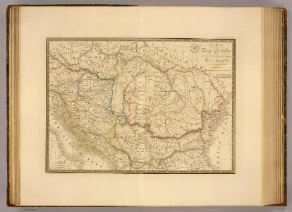
Dacie ancienne, Pannonie, Illyrie, Moesie.
1 : 2900000 Picquet, C.
Ungarn in seinen kirchlichen Verhältnissen vom Anfang des XIV Jahrh. bis zur Reformation
1 : 3700000 Ungarn Kirchengeschichte
Dacie, Pannonie, Illyrie, Moesie Ancienne.
1 : 2886000 Levasseur, E.
Ungarn u. seine Nebenländer vom Anfang des XIII Jahrhunderts bis zur Schlacht bei Mohacs 1526
1 : 3700000 Ungarn
90-91. Danube Countries. The World Atlas.
1 : 2500000 USSR (Union of Soviet Socialist Republics).
Novissima et accuratissima toti. regni Hungariae, Dalmatiae, Croatiae, Sclavoniae, Bosniae, Serviae, Transylvaniae, cum adiacentib. regnis et provinciis tabula
1 : 1600000 Bosna Sandrart, Johann Jakob von J. J. von Sandrart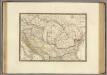
Dacie ancienne, Pannonie, Illyrie, Moesie.
1 : 2900000 Brue, Adrien Hubert, 1786-1832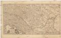
Totius regni Hungariae et adjacentium regionum tabula
1 : 2177000 Dunaj-oblast Visscher, Nicolaes Jansz. per Nicolaum Visscher
Karpaten-Länder
Donau-Karpaten-Gebiet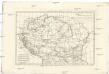
Pannonia, Dacia, Illyricum et Moesia
1 : 4270000 Dácie Bonne, Rigobert André
Ungarn und seine Nebenlande vom Regierungs-Antritte des Hauses Anjou bis zur Schlacht von Mohacs 1526.
1 : 3800000 Spruner von Merz, Karl
General Charte vom Ungarn
1 : 890000 Bukovina (Rumunsko a Ukrajina) Güssefeld, Franz L. Rausch, J. Homannischen Erben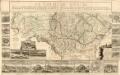
Le Cours Du Danube
Mollova mapová sbírka Fer, Nicolas de Fer, Nicolas de
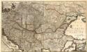
Hvngariae ampliori significatu et veteris vel Methodicae, complexae Regna: Hvngariae Propriae, Croatia, Dalmatiae, Bosniae, Serviae, Bvlgariae, Cvmaniae, Principatvm: Transsylvaniae, Despotatvs: Walachiae, Moldaviae, exclusis ab eadem alienatis Galitia et Lvdomiriria in suas Provincias ac partes divisae et quoad Imperantes ex Avstriacis, Tvrcis et Venetis distinctae juncta tamen propter commoditatem Romania vel Romelia Tvrcica Tabvla ex recentissimis pariter et antiquissimis relationibus et monumentis concinnata, ac secundum leges Projectionis Stereographicae legitimae descrita a
1 : 2500000 Mollova mapová sbírka Hase, Johann Matthias Homann, Johann Baptista - dědici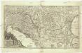
Augustissimi et invictissimi romanorum imperatoris haereditarium regnum Hungaria
1 : 2000000 Besarábie (Moldavsko a Ukrajina) Sedlmeyer, Ioannis Pauli Heckenauer, Jakob Wilhelm J. P. Sedlmeyer
Etats Danubiens.
1 : 2500000 Vivien St Martin, L.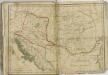

Karpatenländer, Flusz- & Gebirgskarte
1 : 6000000 Donau-Karpaten-Gebiet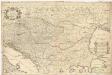
Le royaume de Hongrie et les estats qui en ont esté sujets, et qui font presentement la partie septentrionale de la Turquie en Europe
1 : 2250000 Bosna Sanson, Guillaume Jaillot, Alexis-Hubert chez H. Iaillot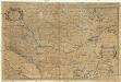
Le royaume de Hongrie
1 : 2300000 Bosna Sanson, Nicolas H. Iaillot
Hungariae
1 : 2600000 Balkánský poloostrov Hase, Johann Matthias Homannianos Heredes
HUNGARIAE ampliori significatu et veteris vel Methodicae, complexae REGNA
1 : 2600000 Bosna Hase, Johann Matthias curantibus Homannianis Heredibus
Hungariae
1 : 2600000 Balkánský poloostrov Hase, Johann Matthias Homannianis Heredibus
Der Donauraum
1 : 1500000 Dunaj-oblast Justus Perthes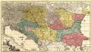
Theatrum Belli Russo-Turcici
1 : 2100000 Mollova mapová sbírka Probst, Johann Michael
Accurate Landkarte die Königreiche Ober- und Nieder-Hungarn, Slavonien, Croatien, Dalmatien, Bosnien, Servien, Bulgarien, und Romanien, das Groß Fürstenthum Siebenbürgen, die Fürstenthümer Moldau, Wallachey, Bessarabien, die Oczakowisch- und Crimische Tartarey, die Pohlnische Provinz Podolien, wie auch ein Theil von Ukranien, und übrige angränzende Ländere
Mollova mapová sbírka Lidl, Johann Jakob Lidl, Johann Jacob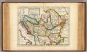
The north part of Turkey in Europe, Slavonia &c.
1 : 5500000 Moll, Herman, d. 1732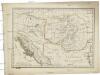
Pannonia Dacia et Illyricum
1 : 3041000 Dácie